

Typhoon Tip
-
Posts
44,251 -
Joined
-
Last visited
Content Type
Profiles
Blogs
Forums
American Weather
Media Demo
Store
Gallery
Everything posted by Typhoon Tip
-
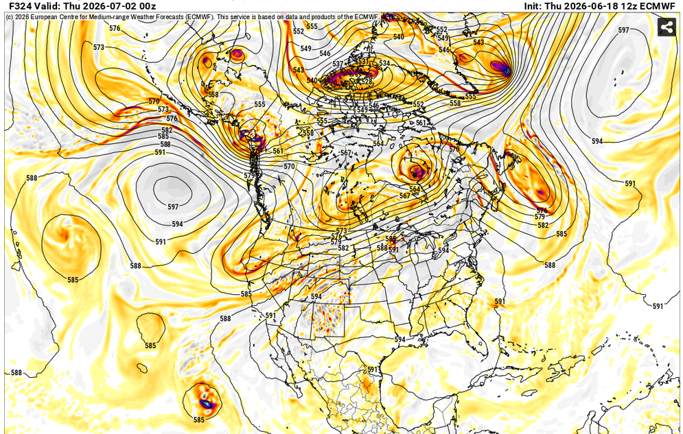
Signals getting stronger for a significant heat dome D8-11
-
Lot of crispy tcu going up. Can see your anvil bombs on the N-NW horizon. Fun day
-
It's interesting how that thing's changed over the week running up to it ... It was originally sort of weird quick coastal ( that looked dubious, admittedly), replete with a burst of NE flow and drilling rains ... Probably 60 F tops. Now, it's more like it's just a humid disjointed morass with less structure overall.
-
Euro's been more and more leaning away from a strata rain look toward something more convectively distributed later Monday afternoon. That tells me that's capitulating over time and model runs, slowly toward less of synoptic forcing scenario - though some would likely remain/still be present with that. The NAM's most recent run could be N-W bias overall ... a failing not uncommon to that model as I've said 327 times over the last 20 years, and it gets conveniently forgotten when it is the only model showing a snow strike in an otherwise suppressed consensus. Anyway, that 06z NAM solution tries to warm sector SNE which strands the region on dry ground because the impetus for raining at all has always been PWAT flop over the antecedent cool/dry air in place type of deal. If we warm wedge...that shuts off that mechanism. The "cool" front then limps through with limited fan fair because mechanics are too weak. wah waahhh. GFS still offers the overrunning general wet hope ... albeit light. One aspect consistent with all guidance is that there is a PWAT anomaly being either pressed up against, or succeeding in overrunning ... that offers a higher mesoscale error in QPF because the convection uncertainty/placement. Expecting some variability in results. Spectacular early summer weather Tuesday afternoon - Thurs. Bit of heat signal still looms ~29 - 3rd, and actually has become more significantly suggested in the numerical values of the telecon from all three sources. However, the spatial/synoptic manifestation of that is still ( if ever ...) middling impression. Euro wants to be west enough that we never taste it here.
-
Like the 06z NAM ?
-
man, that's a o.d. of Clonazepam suite of models and indices.
-
Yeah the GFS is suppressing things. Euro looks like a sneaky small stream responder problem event there.
-
Line came thru here about 10 min ago ...now light rain entrails. Had a few minutes of 35 mph gusts under a gnarly looking shelf base, then 10 minute of moderate to heavy rain. Not a single lightning flash. Not a single rumble of thunder. Not even in the distance.
-
Dangerous heat signal on this Euro run... GFS not as aggressive but hints. Granted these are around the 1st of July, so it may just be eye candy for heat enthusiasts
-
Just got my 80 ... 80/67 rustling breeze with cracker alto strata and a few scud shred moving swiftly underneath. Intervals of sun. Actually feels like an tropical island morning.
-
This could be fun... we clearly have a warm frontal thrust/wedge now up to EEN and we're opening the skies to sun. Temp popped 4-6F in the last hr west of ORH up through FIT and across my region. 79/67
-
yeah SPC mentioned 'low top' in their coverage. I suspect they went tor out of respect for the llv jet in the area.
-
Decent destabilization going on ... 77 to 80 suddenly with 66 dps. Sun splashing and a nice llv S jet wobbling the trees. any thunderstorms rollin into this will be set up with +helicity
-
T-watch Envious threat primarily N of Weatherwiz
-
Warm boundary slipping thru now... 75/68 sky light breaks 69/64 under schmutz last hr
-
There is a 24 hour tele connector that exists because it’s statistically significant that’s all I’m gonna say I honestly don’t need the meteorology lesson
-
Heh... they did expand the Slght into NE after all
-
agreed... wild digression ...buuut: all of society is bottle-necking reliance with technology. While doing so, there's no redundancies. There should be back up systems that achieve the same tasks, like in "off" mode, ready to be turned on in the event of calamity. It's getting closer to a one system handling everything. Banking, to heart surgery, to flying airliners, to surfing porn on the web, and everything else that machines civility along, if that one agency goes down, heh... It's too easy to even write that Sci Fi dystopian novel. First, make the entire species slaved to one system, which is eventually either by design or hostility, taken over by a proverbial Skynet type agency ...and well, shit - we've already seen that movie, huh. But anyway, I see this kind of thing all the time. I wish they still would run old systems that worked, but were abandoned because of the evolution of ease and convenience. Like if the NBM future system has an outage... we can still look at the constituent parts.
-
Yeah.. this is what I was suggesting to you yesterday ... there's a warm boundary that the Euro and GFS are less coherently defining. The NAM on the other hand is kinking the PP enough to suggest a triple point goes underneath Logan. I have seen both scenarios verify in situations like this. I am not presently seeing anything that argues for either. About split.
-
mm... this doesn't lower the value nor significance of the statistical correlation - which is synoptic/ holistic in scale. Not a discrete convective level/meso analysis/indicator. Which there are no known telecons that can be that predictively discrete. For obvious reasons... The point is that the set ups tend to move that incremental spatial-temporal range in the 24 hour window. Hell, not every +PNA/-NAO creates a winter storm here, either, and that's dealing with scales that are far more obvious to the physics.
-
in this case, not any specifics, but I’m better than 50/50 that cool ‘potential’ before the end of June, we are in back below normal, is subjected to being modified ….how much so remains to be seen… And that bigger heat’s likely returned by July 1 … which means it could even be earlier
-
Lol well, I’m not in any kind of troll fight between you two I’m just trying to clarify what I’ve already said many times too, about those probability charts, but everybody keeps posting them like it’s a colder than normal outlook. He may not have intended that just makin sure .
-
You sound far too certain of that for 222 hours out Also keep in mind those are probability charts are not actually cooler than normal in the scaler sense It’s telling you, there’s a low chance for cooler than normal and it doesn’t say how much cooler is normal either
-
2026-2027 Super El Nino
Typhoon Tip replied to Stormchaserchuck1's topic in Weather Forecasting and Discussion
Seemin' like y'all tryin to will a super phat dope ass nuclear nino -
Drive 12 hours in any direction on land and you're still 90 or better


