Typhoon Tip
-
Posts
44,568 -
Joined
-
Last visited
Content Type
Profiles
Blogs
Forums
American Weather
Media Demo
Store
Gallery
Everything posted by Typhoon Tip
-
The loop I just provided suggests we might be in trouble by 2 ...4pm
-
https://www.star.nesdis.noaa.gov/GOES/sector_band.php?sat=G18§or=gwas&band=GEOCOLOR&length=24
-
Did the Trump admin finally just shoot down GOES ?
-
He should crack the window of his cruiser
-
2026-2027 Super El Nino
Typhoon Tip replied to Stormchaserchuck1's topic in Weather Forecasting and Discussion
I was just looking at that stuff... According to CPC most recent power point, yet the present NINO 3.4. regional anomalies ( found here: https://climatereanalyzer.org/clim/sst_daily/?dm_id=nino3.4 ) are already floating around +2.00 C. So, either their CFSv2 product is less accurate as a predictive use ( by over a whole deg C ), or... Climate Reanalyzer's data is suss. I don't really care to get into that ..per se, I'm really just more interested in general with the comparison between monitoring vs modeling: where are we?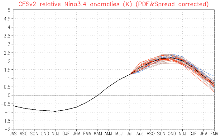
-
I just saw a meme on Instacrap that labeled 838 concurrent wild fires draped from N Alberta to western Quebec across the Canadian Shield Who knows if that's true or not but it does spark the question for me, what is the average number of Canadian wild fires per season? assuming a 'season' is whatever April through whenever October
-
mm ... I suspect the trepidation surrounds whether the population is a controlled drop, or is just something that's emergent and the exactitude of causality is open to mystery. Everyone's been taught that population growth has gone on unchecked for generations and that needs to stop... of course. But how that happens: it's either a controlled landing, or it's a Value Jettting
-
that's what I meant by, "or generationally" more or less
-
Meh... 8.5 billion almost guarantees that it would take something just shy of the planet disintegrating into a new asteroid belt around the sun to get rid of everyone. More likely, there will be upsets in the constructs of civility as we know it, part of which will be population correction event(s). Whether that comes in instantaneous calamities or generationally, it's forced one way or the other. Some remain though. Ironically, this whole disclosure phenom sweeping society has this huge abstraction of "ontological shock" - talk hyperbole! geesh. But, ironically ... probably it won't be about technology that's been hidden from the machinery of civility since 1947... like harnessing 0 point/quantum blizzum blazzum, or gravity propulsion... whatever the fuck I suppose it isn't impossible. No, no more likely any real ontological shock over the next while is going to come for the vast majority that couldn't or would believe it, now ... can't believe they are actually dying because of decades of impudence to the crisis. Anyway, if the 0 point bs and anti grav is true... that would help save this thing. problem is, the Earth has not caught up yet... Even if we immediately stopped adding and forcing,... the apex of the crisis is calculated geo-physically to be still out there decades off. There needs to be a offset/correction plan. Otherwise, the temp will continue to rise faster than species adaptation rates, and humanity is betting its future on hope. Heh, you know ... our species figuratively sold our souls to tech ... now, it appears tech is going to have to save our souls.
-
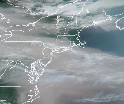
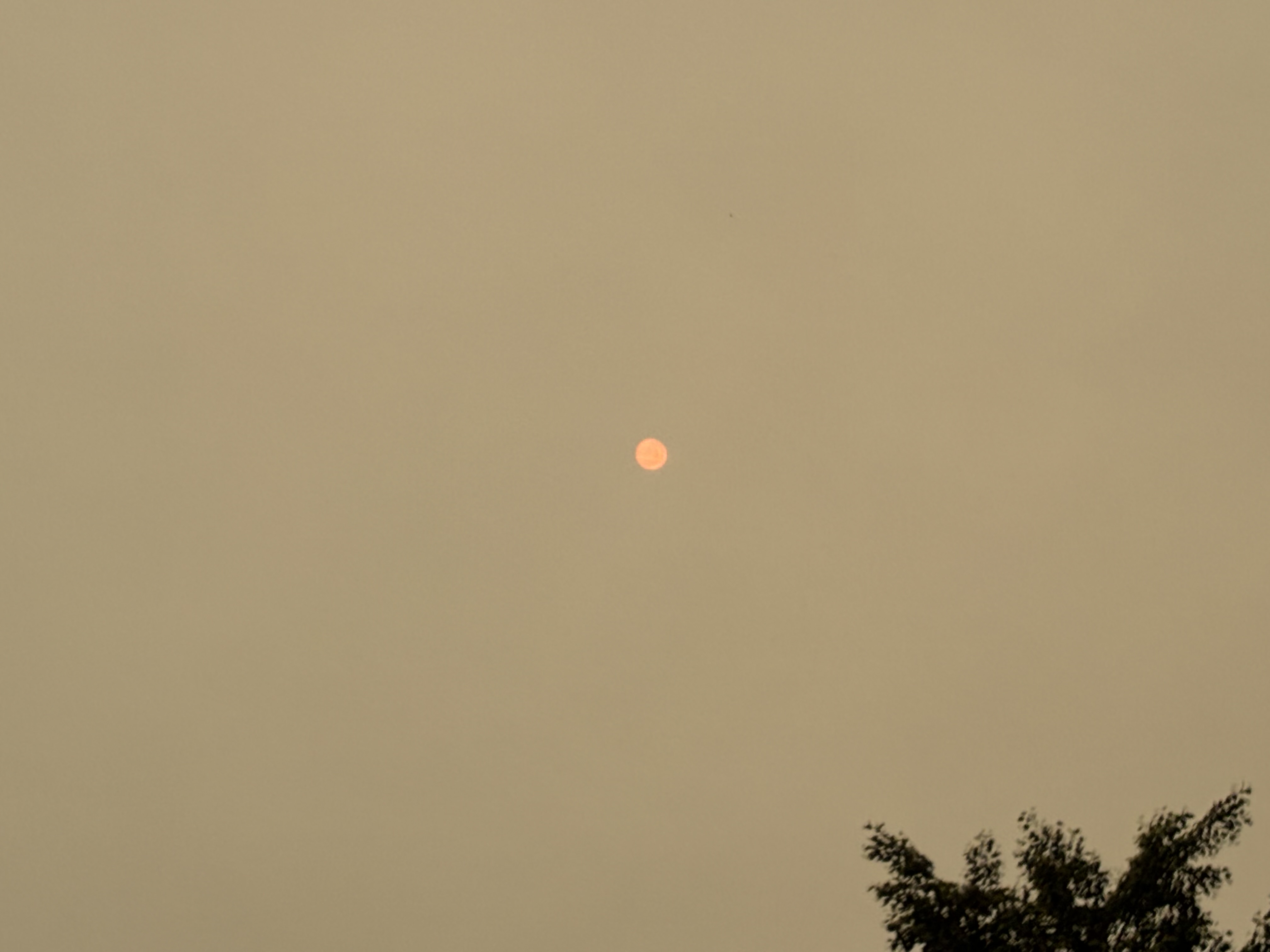
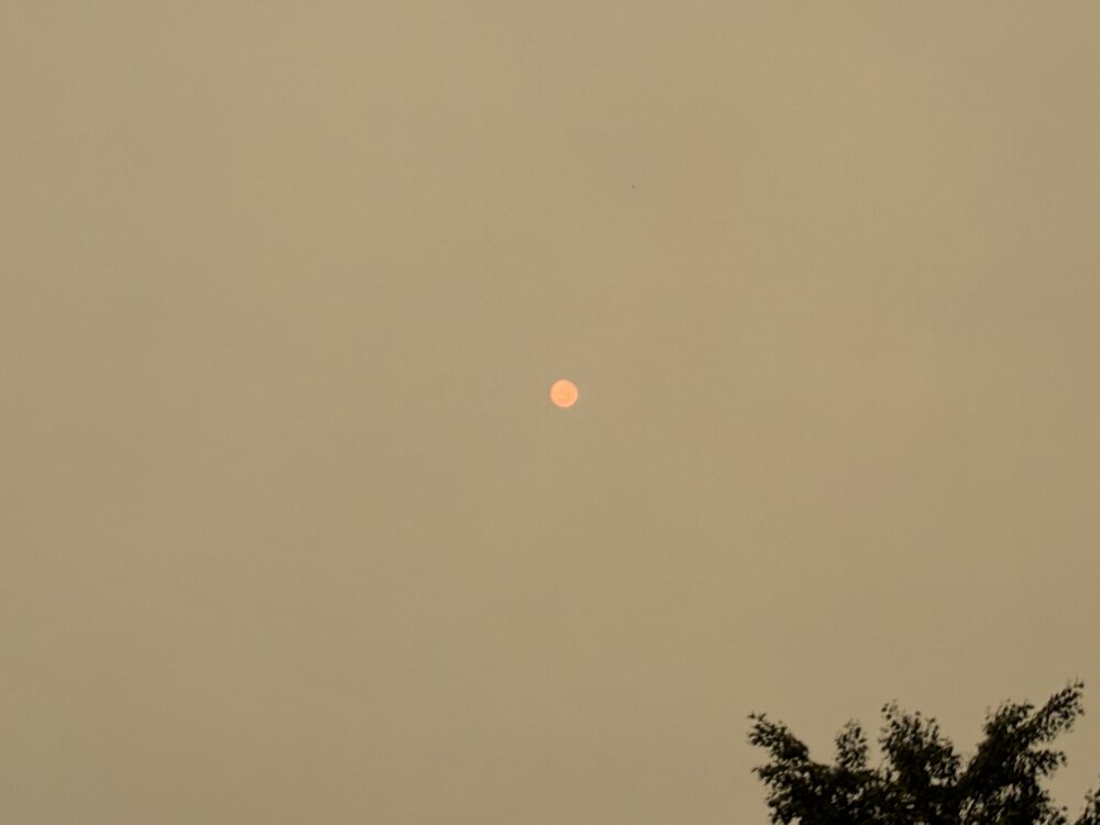
It's the CC that's fake or over hyperbolized that's "not" causing massive upward frequency of these large scale "holocaustic - like" fire explosions setting off all over the world over recent years... This is how Gaia rids the planet of cancer. She/he/it slowly turns up the heat up on the frogs, using temperature like chemotherapy. With brilliantly insightful enabling throughput of "there's always been wild fires", this keeps the agency smoking, so there's more cancer, thus, more chemotherapy ... turning up the dial toward their own demise ever more, over closer. I also like the metaphor for the "Clean" end of said dial on a conventional electric oven's settings. We just spent that last hour at about the equiv light of a cloudy 8:24 pm Here is the sun now that it is attempting to get brighter - albeit in a sickly yellowy aura to the air
-
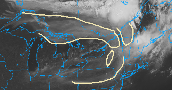
Girls look like super cells up in Ontario about right across the border though
-
Not sure I like this choice to to pass the DLT Maybe the Senate will block it
-
I never was a fan of big heat for this week… Granted, I didn’t see smoke being an issue in the day’s running up but I never liked the structure of the ridge and the way it was collapsing like that. It looked like a one afternoon of heat and then we get bullied south. Having said that even that looks like it stepping off a bit Go wonder models were just over amplified
-
By Indy, do you mean Indianapolis? I don’t think Indiana ever had daylight savings unless they changed that
-
SPC is clearly hedging off though Words like “unclear“ or pretty good indicators that things aren’t really looking the way they were yesterday and how could they be… Might be about time for them to admit they were just as smoke boned as everybody else’s forecast.
-
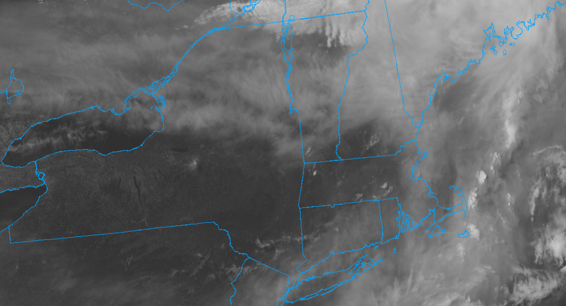
Meh another banded/plume's settling thru the area in a couple hours as this image's looping is SSE

-
88/71 here ..suns stronger as well. Won't verify advisories ... but it's still warm. - actually, it appears they've canceled headlines
-
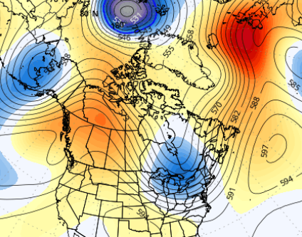
Yeah ...ensembles means are not likely to be as deep as operational versions at this range. It's just logic. If you have a pool of members, there's apt to be some that are always less - that weighting skews the mean... duh. So when the operational are that deep, the ensembles look like this, below - which is consistent with their summer +PNA during that time range. Which is still cold for warm enthusiasts unfortunately
-
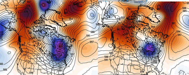
12z Euro/GFS both pushing the bounds of credibility with that (apparently) unconstrained trough depth around the 21s/22nd ... The indexes have an unusually amplified +PNA numerically signaled in that time range, so some sort of anomaly is okay but ... egads! doesn't have to -3.5 SD, either. I guess in order to balance the hemisphere for all that French rage the models have to hang their asses over somewhere to make the world fair.. lol
-
They've got no way to stop that fire storm up there, either. this may be a smoke problem going forward ... clearly wasn't assessed in/for today - not sure how it's done tomorrow. Altho- we may end up with more a NW component which could shunt it maybe NYC ish?
-
smoke induced double bust ? heat... joke convection ... stumped
-
I suspect I know what his source/reasoning therefrom is ... or was rather - you never give that information when you repost so we have no idea... But the problem I have with it is that there is a whopper +PNA between the 19th and ~ the 24th... unusually big numerical values for summer. Showing up in the chart layouts ( ens mean of all three majors - ), too SO, assuming that happens.. these longer range heat signal have to survive modeling our way through these nearer term index walls. It makes it less than trust-able what's happening on the other side of those. Having said that... yeah, there's 'bounce back method that's valid. The +PNA is a cool anomaly that isn't really supported well given the background...so if the pattern goes that way, the recoil - for lack of better word - could imagine an equally handsome -PNA expression ... which ^ certainly is
-
It's actually normal for nocturnally driven MCS to decay after sun rise. Granted, that one did have a weak perturbation in the flow that helped ignite it way up there overnight, but once that happened... part and parcel to the vitality of the S part of the M C S ( mesoscale convective system) is what's known as "radiative cloud top cooling" ...this factor destabilizes the region over the MCS at mid and high levels; a smaller quotient of what is needed for the overall instability/machinery for the embedded convective cycling to keep going. Sun rises; that factor disappears. poof. Anyway not sure what happened last month but just sayn'
-
Yeah it's fascinating on satellite. Now that the MCS is diurnally in decay and it's anvil is evaporating, it's exposing where the smoke is... You wonder if it will offset CAPE production for your convection later on