

Typhoon Tip
-
Posts
44,476 -
Joined
-
Last visited
Content Type
Profiles
Blogs
Forums
American Weather
Media Demo
Store
Gallery
Everything posted by Typhoon Tip
-
Problem with big heat ..particularly nearing the top of physical plausibility ( which this has potential to produce ...) is that we have to think of it as maxing. That means by default it becomes easier to correct downward based upon least excuse imagined than it does to try and push the top thru geophysical limitations. It's true... one wrongly timed cirrostratus this, or the 850 mb hottest pulse ends up at 06z instead of 15z ... these thus become critical as limiting factors. Synergistic heat wave, notwithstanding. Having said that, this could cap out at 95 and bust the mid range hundos, and we'd still verify a heat headline scenario. So it's really a matter of bragging rights whether we make 101 vs "only" ping high 97s out of this. I don't think those 105's were really very realistic - ...or in the least, sufficed it is to say, given what we know of model tech error and biases at D 5-8 range, we'd need to have ti be the next day ( as in 24 to 36 hour lead) before a regional record stroke of that amount is confident.
-
Heat watches up for 5th period ... ? huh
-
Looks like the NWS is now getting gated... jeez
-
word - I'm mostly preaching to the others
-
yeah, there's a trend here to scale back the heat collapse. We'll have to see on that but ...the 00z Euro was extending matters and now this 12z GFS is definitely backed off the calving S out of eastern Canada look it was previously selling over next weekend.
-
To be fair, the 'white' region is 'equal chances' which pertains to either above or below normal. I think what trips people up is both the structure of the curves of those, plus the colorization. both inspire warm(cool) depending where the orientations layout. But, that product isn't scalar cold or hot. It's purely a probability. And the below area? that's not overwhelmingly high odds for below, either. So scoring this based purely on probability, that's not really a fail. It's certainly not good. But it's not an F
-
I wonder what it would take to make a load balanced system capable of bringing on the international constituency
-
This is looking increasingly more synergistic in nature as the time nears. It’s kind of funny too because just last week or maybe the week before… we were sort of questioning whether this could ever happen here hm Nothing’s happened yet so we’ll see what this looks like over the next couple days of new modeling solutions but… this has inched into a remarkable situation for the time being the strongest signal for >100 degree temps lies in interior river valleys and larger urban areas. Equally concerning is the signal for limited cooling at night mid week. The NBM shows a widespread 60-80% chance for low temperatures above 70 degrees Wednesday to Friday, with a 50-70% chance for lows greater than 75 degrees for much of Southern New England! Seeing signals for extreme heat impacts appear in Heat Risk guidance with widespread Major (3/4) impacts expanding over much of the CWA on Wednesday. By Thursday, several urban areas including Boston and portions of the CT River Valley may see Extreme (4/4) heat impacts. Levels like these are typically reserved for rare and/or long duration heat with little overnight relief.
-
Compare the Standard Deviations ... Instead of personal bug-up-butts about whether other people have biases or not, why don't we put some sort of math to the test and figure out which anomaly is greater? I dunno. If modeled 100, three days in a row, is a smaller SD than modeled snowing at 6K+ in the west under 560 dm core than okay. I wonder if the anomaly is more so in the heat side of things tho -
-
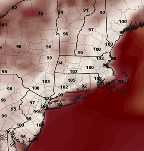
Fwiw, the ICON was the first model to commit to the ridge being more E. Rare win ... at anything for that model Here's it's 2-m for Thur mid afternoon
-
It's a SW ejection, yup. Sonoran or New Mexico, just labeling but by convention this is a SW Heat Release ... you can trace the air mass back and see that. I can see why the Euro has some convection overnight, Wed night, because there's undoubtedly a bit of (thus) EML over top.
-
was this a Sonoran release ... huh
-
Jesus, the 850s are 23 to 25C on the Euro too. wtf
-
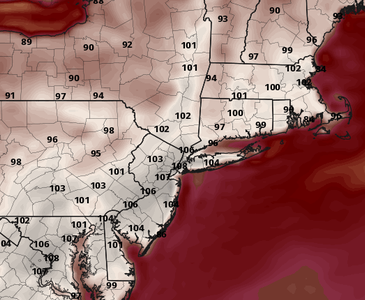
So, the Euro has 3 consecutive days of 98-103F from interior NJ to SE NH, Thu-Sat. It's interesting that the GFS goes full tilt on Wed, then backs off from there on out, whereas the Euro maxes later. I dunno. I'm with Brian on those crazier numbers on Wednesday. I see that this synoptically/circumstantially will be quite hot, but I think it plays a bit into the GFS tall BL tendency - maybe giving us a false sort of synergy there. If we're still hitting these number in the guidance tomorrow, we'll see.
-
Euro hints at nocturnal convection overnight Wednesday ... that'll pube the heat back if that happens but overall, the ridge integral is slightly more massive in totality Wed-Fri. amazing. Friday's just nuts. But again...these 2-m products are heh
-
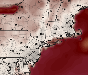
I don't recall seeing the MEX be 101 at KFIT over 96 hours away. That's about 20 over climo at range when it's weighted too. 102 at BDL! 98+ ASH/MHT.
-
This is 105 hours away ... above 80 percentile confidence for a heat wave in general, and here... we're banging 2-meter temperatures like this: Granted, the GFS tends to over mix but... I dunno in the case. Brian, any opinion? From what I am seeing ... the synoptic parametric constraints actually support something extraordinary here. Sorry if that "hyperbole" offends a few self appointed rhetoric police, but it is unfortunately for those officers objectively true. +23-25c 850 W to WNW light d-slope oriented compression flow type < 50% RH at typical ceiling sigma levels during the 12z to 21z interval(s), Wed and Thurs We will have 0 problem mixing probably to the 825 mb level for that matter... A the pure adiabat from a 25c 850 is ~ 40c at 1000mb. 23c is 38 and a half. And these are not continuing the curve into the 2-m right slope where is going to be warmer in that sfc contact layer.
-
GFS was ticket warmer even (12z) in the complexion of that
-
#MeToo
-
All guidance looks smoother and less perturbed... fully committed to a signal almost 2 weeks in the making. Cleanest 500mb ridge cinema yet, one that's also 3 to 5 dm larger in both the x-y plain, and z coordinate integrals in the objective charts. Nice dome, because by geometric definition, that's exactly what a fuckin ridge is - unless you're on the spectrum. Now we can rely on it for communication and clarity, and since 500 mb is the only metric that really counts, there's no cause or reason not to hype the hell out of this sucker weee
-
Occasional Thoughts on Climate Change
Typhoon Tip replied to donsutherland1's topic in Climate Change
Well, yeah that but I was talking about Western Europe a resurgence scenario. That ridge I annotated west of the Iberian Peninsula is in a critical mode/danger of engulfing the region episodically. -
Occasional Thoughts on Climate Change
Typhoon Tip replied to donsutherland1's topic in Climate Change
Don if you wanna look brilliant, I'd go and start suggesting if now outright warning western Europe to watch the July 4 weekend .. signal's grown across 7 consecutive model cycles as trend on top of a background hemispheric foot that's not actually changed the non-linear/synergism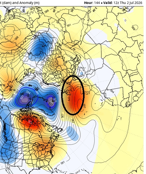
-
Watch up for NH actually ... some minoring threat probably subtends down into our neighborhood.
-
Everything you've said to me to date has been demonstratively high-handed corrective and/or instructive in content, neither of which was or is necessary. "YOU'RE" is because the cap-lock was on and I did not see it - not helping that the site is stalling every once in a while. "Tough cookies" is perfectly fine - it means...no one is going to really care accept you about hype ( that no one really takes seriously anyway? ) which is endemic to the environment you both choose to be a part, and are not going to change. You need to chill
-
For about 4 hours earlier in the day things were moving along at click-speed. Then all at once it was as though a switch happened. Likely AM's traffic is routing through a device with mem consumption issue when there is load-balance switch at their ISP. Which they either don't know is occurring ( unlikely...), or do and are working on fixing it without telling - else they are liable and owe ...so they're douchy heh


