

Typhoon Tip
-
Posts
44,476 -
Joined
-
Last visited
Content Type
Profiles
Blogs
Forums
American Weather
Media Demo
Store
Gallery
Everything posted by Typhoon Tip
-
Last night I did a 5 minute post dinner stroll to try and get ahead of insulin resistance ... and that was about 15 min after sunset in the still warm/sultry evening air. I came to halt and stood their in the dead quite and did not hear one ear whir, and did not feel a single insect land on the legs. I don't know what's going on... we don't seem to have any squiter's down this way.
-
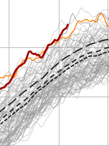
Supposed to be 90 tomorrow and Sun on the same MOS I just impugned haha. Hey, it is what it is. If that's the case, you probably have until that front comes through overnight into Monday morning. Next week looks like a "seasonally BNer" - ie, not ridic just cooler than it should be for the fact that this is going on at the same time... (the brown line is the world ... buckin' for warmest ever against 2024 and 2023 as we speak) Sometimes I think SE Can/NE U.S. are not part of Earth Anyway, despite that weird intention by Gaia to bull's eye New England for enabling deniers, if not hiding CC from Washington D.C. policy makers altogether, ... the actual thickness in that pattern are not appreciably cold. Clears out with WNW breeze in 558 dm -type thickness and it's upper 70s. So there's a sneaky sort of aspect in that, too -
-
Okay ... heh I don't think this is the fault of the numerical models. All of them, including the NAM ... had 700 and 500 mb substantive RH pollution through mid afternoon today. Yet, the MOS (MET and MAV) guidance have "SC", which stands for scattered ( significant solar rad penetration inferred), with temperatures going birzirk to the mid 90s. At least for present hour, it's a reasonable explanation for the discrepancy. The interpretive algorithms ( MOS) are thus somehow statistically offsetting the objective guidance, which would be an error to do so in this case. The cynical explanation because I hate everybody ... this is a nice and tidy example of how you manufacture a bust... You get a "lazified" Met society, getting too used to slouch AI and tech in general to do their jobs for them, and in their reliance there is thus a lack of applied Meteorology to the data. A piece of shit work ethic that gets exposed when the these coffee break solutions in turn fuck up. Ha. I dunno... maybe the forecast gets saved by the bell so to speak if this grunge some how suddenly uncaps the sky.
-
Should this ceiling contamination go on much longer we're looking at a significant temperature bust today - I'm sure Ineedacoldbullshitfilterlikeanalcoholicneedsaclinic will stamp a 100% emoji on this ... but CT also just cleared out rather abruptly over the last hour. Interesting, considering they were wet down there last evening - but this material is mid level so probably not related to that same murk. Either way, temperature can't really rise unless the clearing down there expands. We'll see. We'll rise fast if that happens, but already we're behind yesterday despite the higher launch pad.
-
Epicosity between Northern Illinois and Southern Michigan One contiguous line of tornado and or severe thunderstorm warnings from Grand Rapids Michigan to Springfield, Illinois, actually all the way down to Texas
-
actually these don't appear that impressive. there's not much shear organization. More pulse variety.
-
Cheshire Village area down there
-
True ...I haven't heard any news breaking out of that area tho so it might not have resulted as awesome as that scabby bowed radar looked. These rad products...I swear they're getting goosed for marketing click bate. That thing's rad Rembrandt looked like an atmospheric tsunamis of hail, rain ... leaves and roofing shingles on the leading edge of a-bomb p-wave.
-
looks like my high's 91 ... but with 72 DP it's definitely the highest HI of summer so far. We did get that 97 F day back in the heat wave early in May, but the DP in that was like 53 or something parched.
-
It might slip S of you even... but for the time being it looks like CT's under the gone as that one severe cell is now grouped into a cluster of CB/rad bombs moving ESE from S of Albany. Slow movement though..they may be terrain assisted.
-
well ...looks like the models are going to nail the idea of we get blazing heat with nothing to show for it here in the east. no shit -
-
If you're not in a flash flood watch or a derecho warning, your in a tornado watch, severe thunderstorm watch, or high heat advisory, from boston clear to cedar rapids. can't get any deeper into summer than that
-
Occasional Thoughts on Climate Change
Typhoon Tip replied to donsutherland1's topic in Climate Change
https://phys.org/news/2026-06-earth-energy-imbalance.html -
Occasional Thoughts on Climate Change
Typhoon Tip replied to donsutherland1's topic in Climate Change
https://phys.org/news/2026-06-global-137c-earth-accumulating.html -
Oh my god, I haven't been blue light social media over stimulated in 3 hours, there must be a dystopian wave of horror folding over the horizon
-
That's funny you wrote this... I was wondering how being +2 to +5 for 10 days isn't sustaining? I guess the subjective side of that needs to be brown out 100s for 10 straight days and with Locus swarms, brimstone and and booming voice from the heavens that says, "I don't like you!" lol
-
If anyone is forecasting based upon climate ( and I'm not saying that's what anyone or source actually did - ) they take risks to put it nicely. More of a philosophy of approach op ed: Climate shouldn't be used as much of any correction for any scenario. We look over all these modeling depictions and/or cinemas going out way in time.. comparing those to trends ( which trend is a lost/deeper art than most are aware frankly but that's another discussion - ), we get an idea of/what the biases may end up like. That's our prototype/beta forecast. Once we have that, we can/may/maybe should, reflect on whether or not climate should factor? Frankly, it won't factor very much. Why? because climate is a mean of everything that happens. It says nothing about the SDs that took place along the way - in fact... it hides them! Climate invocation should be limited to the obvious: it's probably won't snow in June; it probably won't be 90 in January - though revisit that in 30 years lol The fact that Climate Change is hugely coherent and objectively real, and cannot be denied by anyone that is not diluted ...eh hm, means that all the above is especially made more true. Because climate inference, itself, is problematic when the proverbial goal posts are moving - not just moving, but accelerating, too.
-
Wow, that's a mean lookin Dercho bitch about to unleash fury on Iowa City
-
sort of... As Brian was intimating, there was conjecture/interpretation for a cooler first half of June back whence. I personally give that the benefit of the doubt ( although privately ... there are those that falter implementation of any 'cold bullshit filter' so they may have a bias contribution that it's totally going so snow on July 20th ... weeee Excluding that contribution though ), but in doing so, was adding the notion: it seems that verifying warmer than guidance is overwhelmingly the observation compared to colder than guidance, regardless of future patterns being offered. I mean it may have even verified a cooler "looking" pattern, but for whatever reason ( probably CC, let's get real - ) your likely to flop on the warm side.
-
I can tell you these 'feel' correct... Approaching 10, and these have another update coming... so, 10 after 10 pushes this deep into stifling and prooobaly more warning level heat than just Advisory from about 1pm thru 5pm... I don't know what the time requirements are on the headlines so not criticizing there, per se... but if we tap 94 ..95/72, that's a damn sizzling HI. By the way, this region appears to be weirdly 2-3 F hotter than everywhere else at this particular time.
-
Fwiw, NWS' climo Prelims have +2 to +5 at their 4 representative sites for SNE thru the first 10 days of June ORH/BOS are absurd and need to be changed, since climate affects POPULATIONS I suppose the Logan one has a sciency usefulness for how the coupling marine environments and all that jazz... but otherwise? no. Using that for "Boston" is just a thorn that is generations overdue to be pulled out. Doesn't matter what it takes or what hardship is perceived, if I were a fascist god, I would tell them to do so immediately or suffer the wrath of discontent that makes president Dump look like the bed of daisies he's about start nourishing ( ...actually, they'd probably vomit, wilt and die ) ORH is a little less egregious. There are neighborhoods scattered around the AP up there on the hill, but because it's geo-physically always going to be 6 to 8 F cooler up there than the swelter below where there's many orders of magnitude more people actually living - to fairly use that as climate is jack shit, really.
-
I wonder if data population schemes are more problematic in summer than winter. Maybe a known thing. Tracing that 500 mb vort paneling backward ...it seems the Euro/GFS are both getting an awful lot of momentum arriving out of the Pacific over the western continent around D5/6, then racing it into a bit of non-linear constructive interference triggering a shallow wave break and bombogenesis - originating along the lofty 570 mb height contour is a head scratcher. I guess it's not impossible... I mean, the models have to at least be physically possible otherwise they have 0 meaning.
-
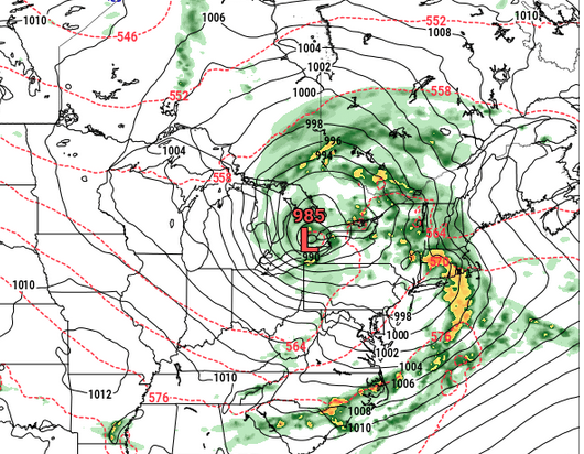
Look at this pig ... 984 mb low near BUFF, yet ... immersed in only 564 dm thickness, having almost no hydrostratic gradients surrounding all quads, either In summer. This is D7 Euro so... meh, no responsibility to accuracy is really there - yet - but that's an example of too much amplitude ( or likely to be...) on summer mid range charts. I like the triple point secondary low forming at the head of the 576 - that combination of metrics you don't typically see, huh
-
Oh, yeah.... I posted their disco excerpt ... "...especially away from the coastal plain. Heat Advisories may be expanded further east; however, a backdoor cold front is expected to drop into eastern MA sometime on Friday" But in their defense... they did mention the advisories might extend east - I don't care to be involved with the petty pot shot at NWS thing... just sayn'
-
? I think there's a pattern relative warm bias that is the CC expression that is sort of unnoticed - or maybe ...everyone knows it but chooses to ignore. I dunno. But what I mean by pattern relative warm bias is that the pattern essences may actually be verifying better than either the temperatures that result, as well as what folk tend to associate what those patterns look like the temps should be. I don't mean that necessarily wrt this last month's behavior ( necessarily...), but I always go ahead and assume two aspects: these 540 dm festering multi contoured hornet stings on the summer D9-13 charts we see over James Bay are not going to do that, and, whatever comes of it...we'll be 2-7F above scalar predictions anyway


