Typhoon Tip
-
Posts
44,568 -
Joined
-
Last visited
Content Type
Profiles
Blogs
Forums
American Weather
Media Demo
Store
Gallery
Everything posted by Typhoon Tip
-
It'll be interesting to test that, the scale/extent/presence of BD over the next two days. Particularly on Friday... I see in the 00z GFS, ultra anal close-up OCD Rain Man inspection, that yeah ... there is a 'bulge' west in the PP over E-NE zones... perhaps as far W as ORH, but we're talking 1 to 2 whopping mb here really... if this is even real. 06z has this less so. I've noticed this about guidance, et al, over the last 5 to 7 years. They have improved significantly in the boundary layer where prior generations of modeling had trouble due to the termination of fields in boundary mechanics. They don't ...or couldn't really, process what is happening as the boundary - in this context, Earth - is approached. That's why they used to miss "tucks" in winter storms of lore, erode cold too fast ahead of warm fronts in general, all that cold lag winning shit. They are better at it, but ... it's like they're getting better assessment by over assessing. I see them create these kind of BD-esque looking features that don't exist, more than they ever used to... right around the same time they've all improved on BL handling in general. So... I've spent probably waaaay to much time on this subject this morning at this point, and it's probably a fool's errand considering the room is empty and no one's even reading this very sentence... hahaha. ...yeah
-
I mean they're spot on with this conceptually, and to an extent with the detailing but they're blowing it with the spatial layout - not without giving a reason why they thinking metro west and Fitchburg -Lawrence and up to Manchester are not part of the diagnostics, which they don't...? Oh, they do okay... I guess they're okay the way they handled - Confidence continues to increase that heat and humidity will pose a risk Thursday and Friday. As the warm front from Wednesday lifts further north, prolonged southwesterly flow will bring a surge of very hot and humid air, especially as 925mb temperatures increase to +27C Thursday and up to +30C Friday. Surface dewpoints are likely to top out in the upper 60s to low 70s, especially across interior MA and northern CT. These high dewpoints combined with temperatures climbing into the low to mid 90s will lead to heat index values approaching 100F Thursday and likely above 100F Friday across the CT River Valley, prompting Heat Advisories to be issued for northern CT and western MA from noon Thursday until 8PM Friday. especially away from the coastal plain. Heat Advisories may be expanded further east; however, a backdoor cold front is expected to drop into eastern MA sometime on Friday Not sure I agree synoptically..I admit to a flaccid PP but I don't see a very obvious BD mechanism, ether.
-
76 at 8:20 am isn't bad. Sat's a grungy mess though. Partly to mostly sunny for now but there's convective debris in heavier patch work lurking near-by west, inching east. The sun may alter the sounding such that some of that starts to vanquish - not uncommon - but we'll see. Heat over the next 3 days is going to be battling a bit of cloud pollution though. Most guidance 700, 500, 300 mb level RH fields are contaminated with occasional 70%.
-
just between you and me ( and the social media'sphere heh)...sometimes I'm wondering if learning AI is being used at NWS offices, and it's not quite up to the task just yet. Like it still needs a helicopter teacher. I've noticed a lot of those kind of hard to explain head scratch nuances. There's not as many in urgent more/obviously significant situations, which makes sense... these latter types are more human eye required? I could see this scenario being "unchecked" yet; in need of doing so. But I'm also a sci fi writer in another life so -
-
Advisory level headline heat tomorrow and Friday ...cloud depending. I imagine the current layout gets extended into metro west of Boston and up the rt 3 corridor toward MHT eventually. Not seeing why Greenfield MA is going to be warmer than the Framingham MA to Manchester NH axis, but we'll see
-
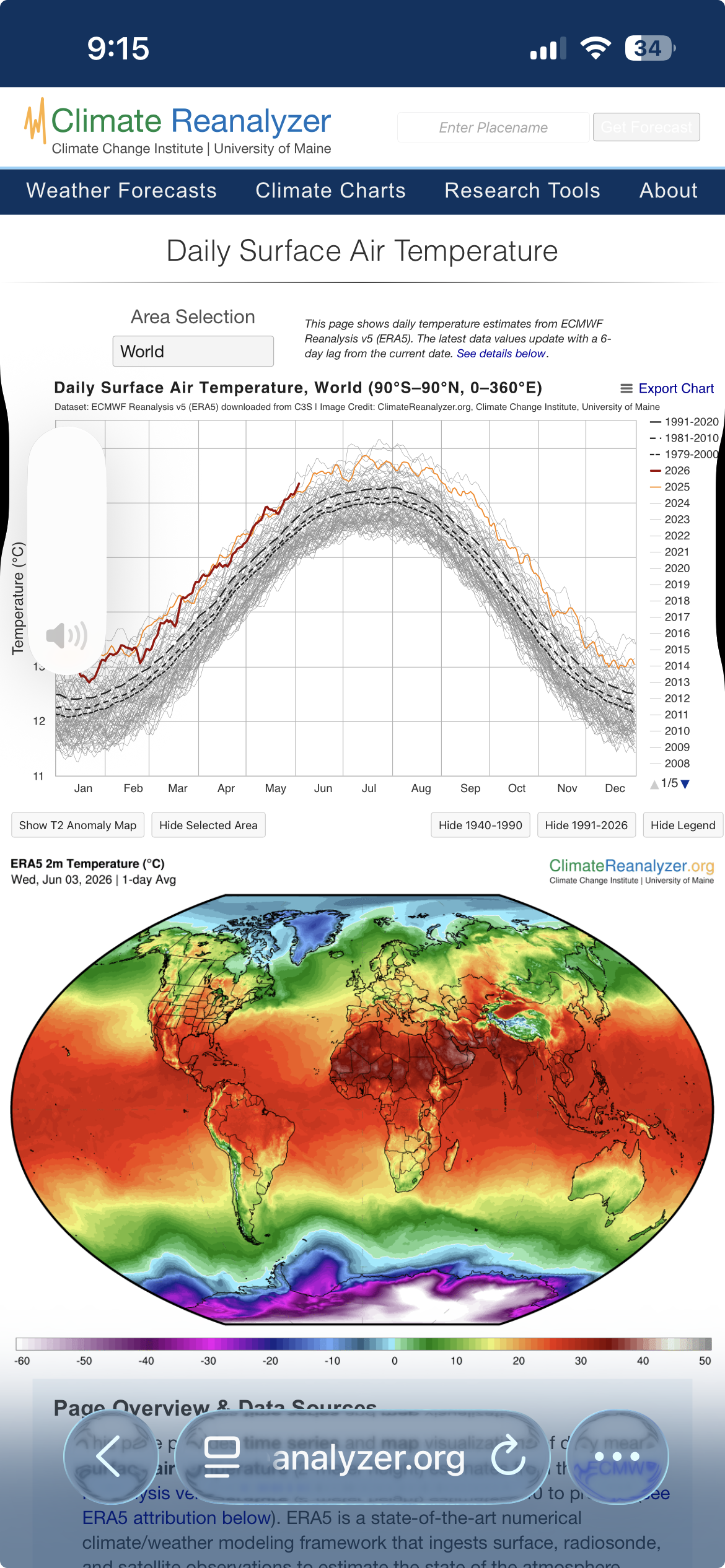
Doesn’t this curve look mean? I’m not so sure that fugger’s gonna hook before it top dawgs
-
Speaking of the NAM grid.... woof. Thickness 572 to 575, first time this season basically sets in now, out thru 60 hours. 850's look like 15C. Lot of a cloud production tho so that probably limits it's already tendency for 2-meter temp retardation a bit. 30C at 980mb in NYC on Thursday tho would probably be 96 in EWR
-
I am not against, nor a fan of Judah Cohen's contributions ... I realize there's been some banter in here that's ranged from flattery to ... not so flattering opinions of the guy - I'm not part of that one way or the other. Having defined that ... I don't have a problem at all with his surmise/intimation there that it bears some semblance to last winter. I said almost exactly that to Brian in a post yesterday or the day before. Whether it ends up "comfortable" like he suggests is different combinations of metric than just temp though. He needs to be careful there ... or at least, the readers/consumers need to be aware. If it ends up normal temperatures ... that doesn't automatically intimate lower DPs to me. Not at this time of year - nor particularly to what the general synoptic trends look like out there. Particularly, if the transient trough in the Lakes starts to retrograde like the 00z ens clusters all agreed it would do... that means it is challenged to really make it COC -like. It would be more vaginal I guess... heh ( puerile humor ). It's a new-ish signal but the neg anomalies associated move back toward the S/W continent just beyond next week. For a real air cleansing... the trough needs to go the other way ... opening up and progressing E.
-
Pleezy weezy with sugar on top let's see that happen. ha
-
I realize the NAM is a dead dog model ... ...are they going to continue running it in parallel for awhile after the fact? Is there going to be gridded data sources from whatever meso madness they're going to, similar to FOUS? May be a Q/A for NWS personnel ... if there's anyone still actually working at NWS since we've gon' and made 'merica all great and all
-
yeah, there's definitely a kind of neg-head bias about signaling NE of the Maxon Dixie. Because we don't get 55 K foot tropopause stabbing nuclear updrafts with stove pipes carving canyons underneath, 'they're not worthy ...' Kidding... but there's something like a wait-and-see thing up here? I've seen more upgrades than planned scenarios - it's almost like that's their policy.

-
So SPC's gonna come around then ? https://www.spc.noaa.gov/products/outlook/day3otlk.html
-
It inched warmer overall from what I'm seeing... It's almost a complexion thing where it looks less aggressive then 24 hours ago. Just about unilaterally, all hydrostatic fields from Washington to Maine were like 2-10 dm taller in the general cinema throughout. However, the 'geometry' or shape I suppose, still looks similar - some sort of a trough in the midwest/Lakes region... the depth of which proooobably shallows some as it nears in guidance. It's not very clear if that actually will be an agency for "cold" delivery here now that I look closer. I agree that it's more "mild down-ish" for SNE... but this may end up being so for you guys, too. For one, these cold amplitude deals ...the models have been overselling them since 2012 and the arrival of the version-upgrades-every-10-minutes era. I think they've swapped beta testing/polishing for some other ambition.. .who knows. One aspect that is emerging... as we near the solstice, all three ens systems are rapidly retrograding said trough - not progressing into a +PNA/summer killer. That numerical telecon has a strong -PNA emerging just beyond next week. Starts falling around the 15th... by "Juneteenth", -2.5 SD. This latter index state was more in the -1 and a quarter range 24 hours ago. It's doubled. heh. Again, all three... GEPS/GEFS/EPS. So taken fwiw, a gambler at the long lead table's putting their bucks down on the idea that what cooler signal does materialize for next week, it's likely transient.
-
2026-2027 Super El Nino
Typhoon Tip replied to Stormchaserchuck1's topic in Weather Forecasting and Discussion
As the humanity bus goes over the cliff… -
Too early for that No, it looks to me more like it’s just a regression to what happened all last winter Very sting Ninos more correlate to a sub tropical jet and on this side of the solstice with summer still suing we are nowhere near engineering that sort of hemispheric response until the seasonal gradient steepens next autumn/winter That is … if it really gets strong enough to exceed RONI numbing
-
Looks cooler to me ... It may be transient but it's hard to ignore or gaslight a -2 SD seasonal regression spv rollin through the Lakes. It may be overselling in the runs and destined to normalize some... okay, but just as is? that's definitely colder.
-
Still wondering if a Bahama Blue circulation mode type might set up ... it's a sloppy way to infer, perhaps... but using the D6-14 temperature anomaly progs from CPC suggests a trough might situated along 90-100 W and sort of stall there for a few days. That might eventually oriented a more S-->N larger synoptic river of air along the EC. So ..."Bahama Blue" flow is a phrase we coined in here years and years ago... It's when there's SW flow through the Gulf o/ Mexico, and a SE flow through the Bahamas that join over the SE/Florida and then flows all the way up to Maine/lower Maritime; east of the trough, west of the semi-permanent west Atlantic subtropical ridge. Variations on that theme can machine but that's the basic format. It's an interesting pattern. It's relatively rare and when it sets up, you can get 84/77 with purified deep blue tropical skies like a typical day in Nassau. You may even observed tropical TCU with teeny intense showers on rad with a single pixel to 50 dbz water boarding rain rates. 20 seconds worth.
-
Part snark, part reality ... ...but it's mostly driven by addiction to dystopian triggered dopa in what's become a blue light over stimulated, recreationally enraged society. If there's no actual Paleocene-Eocene Thermal Maximum reduxing heat wave, or cannon ball-sized hail clouds suspending finger of god's carving canyons through the hearts of urban centers ... then watch out! Drought becomes fanatical and 'quite real'. Sometimes this engagement is just not subjectively exciting enough.
-
Thankfully it was 50 average S of the NH down here. Looks like summer's finally gotten to your doorstop. Needs another little push to finally get N of you LOL
-
66 at the moment by it's just 9am. Maybe 79 or 80 /52 under 100% purified blue.. Hell, even the pollen's at least temporarily alleviated. 1/2" rain btw from that weird late blob that slid down eastern zones last evening. Rained harder than sat cloud tops suggested it should, too. Interesting. Lawn looks visibly appreciative for whatever the cause.
-
We've already seen some contenders this spring and early summer, so in fairness this is speculation pending final judgement... Today is the top 1 day Intangible in support is the fact that it's happening perfectly in mockery of the weekend now being over. So, being collectively imprisoned by thankless jobs and not really available to actually be a part of it? definitely adds to the mystique of this day achieving numero uno status
-
2026-2027 Super El Nino
Typhoon Tip replied to Stormchaserchuck1's topic in Weather Forecasting and Discussion
Kill off entirely? unlikely .. but, attenuation is getting easier to do with the expanding HC, however. Folks also need to start assessing matters in a new paradigm; decadal recency urges that. Since ~2000, the broadening/latitude expansion of the HC has been measured and objectively scienced. A larger envelope circulation does not mean a stronger HC circulation eddy. It in fact means it weakens, with increasing observation of perforations/cut-off and/or TUTTs, combined with weakening trade fields. -
79
-
It’s summer Really just goes back to slightly above normal on Sun - Tuesday and then that’s a heat wave
-
yeah. not here. I'm wonderin if there was a spray thing I don't know about. But I was over in Sterling at Meadow Brook, basically a 1000 acres of orchards, open fields, with woody glades doing disc golf last weekend and there wasn't one. Then I was over at Qual Ridge in Acton doing a regular golf there and again...none. Why is massachusett special