Typhoon Tip
-
Posts
44,568 -
Joined
-
Last visited
Content Type
Profiles
Blogs
Forums
American Weather
Media Demo
Store
Gallery
Everything posted by Typhoon Tip
-
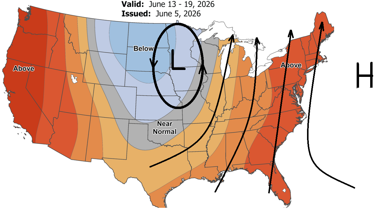
and then it breaks down right when the MDR cane season's scheduled to begin ...
-
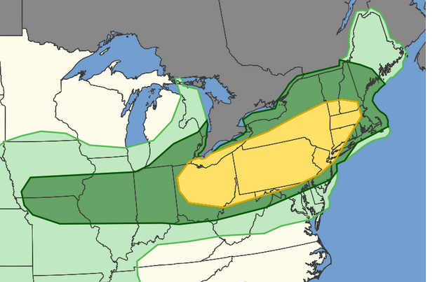
possible broadly defined/quasi Bahama Blue pattern setting up ?

-
-
has anyone else noticed an absence of mosquitos
-
it matters when deniers are using 100ths of a decimal to make dullard points
-
Why, what's up?
-
Pretty damn warm GFS run at 500
-
Well, maybe you’ll have luck with that -narrowing it down as you say. But I kind of look at it this way… Triggers only trigger if there’s an underlying vulnerability put in place. Pretty sure when I removed the processed sugars and processed carbs. I removed the underlying vulnerability. So now those so-called triggers go with it. I hear you about people not truly understanding it though… I cringe whenever I hear somebody say “oh man; I have such a migraine” I’m like no you don’t
-
And by the way, if you absolutely have to have something sugary, you can mix Allulose, which is organic and comes from plants. It doesn’t actually add any sugar to your system … mix with 5% by volume of Stevia, also organic from , and the combination of those two mimic sugar almost identically with none of the glycemic impact on your bloodstream. So I don’t really miss sugar in that sense
-
Yeah, it sounds like you and I came the exact same path in life. Truth be told I stumbled on my cure by accident I was doing an experimental diet for weightlifting, which was high in carbohydrates, but I was eating the wrong kind of carbs and wasn’t really aware of it or actually… I might’ve been aware of it, but I didn’t take it seriously because I’ve never had a problem with it, but I came back with a 6.0 on the A1c and they said I was getting prediabetic that despite the fact that I work out pretty much every day of the week too So I freaked out and panicked and did a lot of research learned all about the different kinds of sugar, how they occur nature, how they occur in industry, what the difference is and how we get them in on purpose or by accident …everything and developed a diet that was completely devoid of any of them Migraines gone. I don’t know, give it a try. It might be worth it. I can see how general Tsao did that too, cause who the hell knows how they’re sweetening that. I don’t dare get anything sweet from a Chinese restaurant since I made this connection. I sometimes get chicken wings though, but they don’t sweeten by the way, it’s funny you called that kaleidoscope because me and my buddy Geoff, who also has the exact same migraines this whole life we call it “K day” in texts
-
Hey Kevin, I pretty much cured my migraines by eliminating all processed sugar and/or simple carbs as much as possible Take some getting used to it and it might seem boring to eat that way, but after a while you get used to it it’s totally OK I was stricken with two maybe three migraines a month for the past 45 to 50 years of my life. Although as I got into my 40s, the actual pain part of the headaches got more tolerable. But I would still get the aura with a distorted vision shit that lasts for 20 minutes to a half hour, followed by headache anyway, I tried a lot of different things about diet with some limited success, but they always just came back. The only thing that’s really worked and I’ve had one migraine in the past two years … only one (and I think I know why ) is no added or processed sugar of any kind and no simple carbs like white bread or white pasta. Sometimes you’re gonna get some of that stuff by accident because we’re Americans and we live under a western cultural diet umbrella but it’s likely related to thresholds of tolerance. If you keep your exposure to that stuff is minimal as possible for me anyway that turned out to be my silver bullet. Upshot is that all those other inflammatory factors if you have any of them get better I haven’t had a cold in two years either by the way, and it’s proven scientifically that it’s better for your immune system if you get sugars from things like fruit, which by the way, you can eat a very sweet mango and a very sweet cantaloupe and the sugar that’s in there doesn’t actually raise your glycemic index I can eat fruit to the cows from home. I don’t get any migraines at all. Beer is OK … Although it’s bad for other reasons, I won’t get into that Gotta have some fun in life though Oh, and by the way, I do on Saturday and Sunday use a little bit of organic Trinidad cane sugar in my coffee, but that’s it. I can tell you right now if I got ahold of high fructose corn syrup? doomed
-
Yeah they flipped hard... SW gusting to 22
-
the N is actually calm - they're fighting though. Temp bounced to 88 which is on par with downtown anyway, but they back to SE at 7 ...altho I doubt they gusted to 59 unless they picked up some jet wash. ha! flip floppin
-
They may be about to flip. The ESE is down to just 8 and their T is up to 82.
-
Agree in principle ... but, I'm noticing here about 30 MI into the interior we've flipped the BL, because we're doing WSW at more than just wobbling leaves. When it's been like this in the past with these sun grown mixing depths, sometimes we get a late W wind burst through the city and Logan kinda cheats a high off the urban fart between 6 and 7. May even be counter-intuitive but what's happening is that that the gradient, albeit weak, is mixing down when max heat gets to critical and the BL turns over. not every time but late highs are thing out there
-
00z Euro was trying to finish as a significant move toward what you describe. It also was warm run over all. In fact, I'm not seeing a lot of "cool" either. I think this summer's sort of pattern dictated at this point. Like we'll be shifting between 65 and 90 and not 40fuckum7 and 65
-
DPs low but it's hot... 89 ... that's about the cut-off where lower DP no longer saves... Hot day
-
yeah, that's a good point. I've come to think based on experience that mlv lapse rate may be our most important metric up here in NE. Maybe orographic forcing offsets some
-
I will give you this much ... waaaaay back when the dinosaurs ruled there was this model called the ETA. It's the ancient ancestral root of the present era's NAM species.... At every point along a species evolutionary past it had specialized abilities... In completing this metaphor, the ETA of 1995 was a spectacular tool for a very specific lesser known skill: convective initiation. That's basically timing when the convective temperature is reached and if there is any inhibition in the region... it is successfully overcome. We would cross up those metrics and it would say 1:45 pm (say) ...and at 1:38 or 1:57 there it was, the first cell squirting it's load on radar. That was a lot of generations ago and the present day NAM... yeah, there's heredity there, but I don't know if it shares in that same unique ability like it's ancient forefather.
-
88 ... delta of 40
-
impressive to see Logan sustaining an 81 on a SE 9 kt wind
-
are you talking about the front, or the thunderstorm triggering - i suppose you could get that pre frontal quasi dry-line trough thingy in that situation. That would actually be ahead of the better synoptic support - which I would not ever side with the NAM on synoptic timing dude. Just don't ...
-
It has unfortunately been exposed often enough, times of misguidance wrt to drug and vaccine therapies (regardless of why) that it's naive and ill-advised now to rely on in-office recommendations, out of hand. You instead should nod thoughtfully and tell the physician not at this time. If the they push ... particularly in that sort of situation, then you respectfully decline and tell them that you will be completing some independent research 'like you always do' before arriving to any course of action.
-
mm far as I can tell it's only the NAM doing that. Wouldn't trust it until more support ... but not impossible, no. I suppose if you really want it to be right so that you can engage and hopefully win another in the varied petty competitions over weather-related statements that goes on in here, there's nothing wrong with relying on it to make Kevin wrong. LOL
-
83 ... 35 delta