

Typhoon Tip
-
Posts
44,568 -
Joined
-
Last visited
Content Type
Profiles
Blogs
Forums
American Weather
Media Demo
Store
Gallery
Everything posted by Typhoon Tip
-
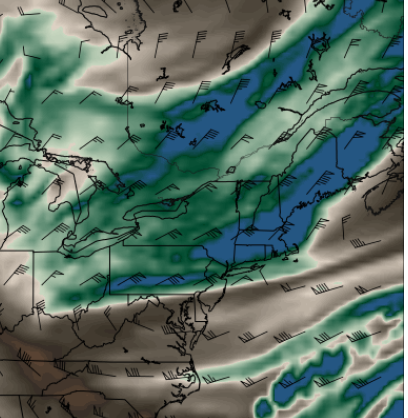
here it is...300 mb
-
Models either missed this 300 mb shit streak or it was just not noticed but it's been completely slam shut ceilings here right during the big warming hours of the day, so ...yet again, 2026 finding the coldest way to weasel bust
-
Not sure ... For whatever method, those are probabilities tho. For whatever metrics they're weighting, not the actually anomalies like this sentence intimates: "One thing I notice a lot is the CPC seems to overdo sfc temp anomalies." I blame CPC - most people misconstrue that product. In fact, I've pointed this out on this site, to the same individuals who continue to do so LOL ... and it doesn't seem to register. They probably - or should ... but who knows - provide an explanation/methodology statement somewhere in their web access. They do have a contact option. The only thing they have is a confidence/probability by forecaster, but don't delve into what the forecaster is actually looking over.
-
those aren't scalar anomaly ranges ... They're probabilities for being above(below) at all... scaled.
-
hard to do that in winter
-
Not bad...this might actually be my steepest (delta slope) recovery I've seen in some time. 41 at 5:40am and just 66 at 8:35 over here at the Oxbo and Shirley NWS sites represent 25 F in 2:55 hours
-
Just thought to clarify: should today's 79 (probably 80, let's get real), and then 83 to 88's thru Saturday verify, that would be solidly above normal - nocturnal lows notwithstanding, but their progged to be 55+ in the machine numbers. Come to think of it, if we get 4-nights back to back of 55-60s, that might be the warmest nocturnal streak since last autumn. I realize you're lighthearted ribbin back and forth, but he was responding to Scott's "no prolonged heat". There is no"re"ribbing him on the same accord - that doesn't count LOL. Seriously tho, I suspect you're neighborhood/township region is a cold climo relative to the region. There are those areas that tend to be warmer owners, there are those that tend to be the cooler in any given scenario. You are the latter? I would not use you're point and click - if that is the case ... - to characterize expectation for any week that includes BDL/FIT/ASH/MHT/Lowel to Lawrence, which typically do well in light wind high sun recovery scenarios in Junes
-
True MEX MOS is 80 to 88 every day thru Saturday ( that includes Saturday ). That's a 4 days of 80s? Decent. I was just musing with Scott that in principle we haven't committed to the warm season yet. We've had heat, but until the basal return pattern state stops dipping lows below 40 this is a zombie winter. Imho of course... There's either a standard c-front (Euro) or a BD (CMC/GFS) late Saturday night and Sunday's on the cool side, but at this time ...the modeled air mass/thicknesses are not that 47 F shit. More like bopping us back to 64. Could be wet, or it could be dry...then ,there's another warm push mid next week - that one looks more like a warm sector Don't have much of a bead on post 15th June yet
-
Still winter if you took a polar rotted January thermal profile and subjected it to June sun, you'd get that January sfc temp to be just like yesterday
-
I don't think we've had "prolonged" heat here for years. We've had heat waves, ...usually falling short of what they could have been when they do with just one day out of them that gets to 97.. Kind of like what happened earlier in May ... some with more or less DP to go along with. But they're too many reasons to neg interfere. I'm beginning to think the return rate around here is so long there's no practical value in really looking much less waiting for them. Those 97 for five days running over lows of 76 with 82 in the urban centers are Chicago to KC or NYC S.
-
I think today's gonna seem pretty warm W of I-95 Wouldn't be shocked if Scott to Ray sniff Labrador's nut sack in the afternoon. Such a weak gradient in place and the intensity of the 100% bake in the interior, seems they delay warm arrival by one last reach back face smack upon exit of this pattern. LOL. Or not... where not, MAV/MET MOS have both inched closer to 80 for today. Right now they're 78 .. 79 around the BDL-FIT-ASH horn. Testing that
-
so a hugely rangy summer then -
-
I wouldn't have any problem with the notion that this is too cold for it's own deep layer mean, a failing not uncommon to ensembles at this range. Aside, the idea was 'modestly impressive' - we're not looking for a UK redux just yet.
-
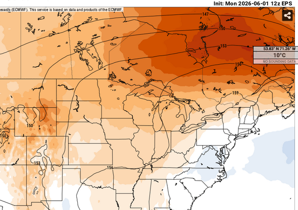
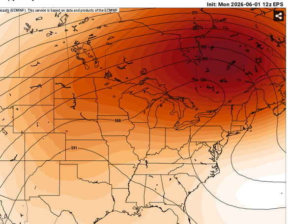
You're one of the one's that can relate to my interest in monitoring heat in the summer ... heh, I mean shit. It's not like it's part of weather, huh But 12z EPS mean, centered on June 9, came in yet a little more impressive with the over top heat look. Weather this is a flash (pun intended), a heatwave per se, or evolves to something else are obviously notwithstanding at this range, but it's being monitored.
-
haha... I'd say at least not totally sucking prison balls at shiv point -
-
64, mainly sun sky with post-card cu utterly opposite condition to this morning, whence it was 48 and light rain.
-
https://www.instagram.com/reel/DY-BOhHuChX/?igsh=MTZweDlmcG9iOTlwcQ==
-
I'm wondering about the magnitude given to some recent obs. I mean it's not hugely scientific to say this, but it just doesn't feel like it's coming on in any particularly mean looking way. Historic anything in this business, tend to get busy real quick. It's not phenominalogically consistent to speed bump with so WWB's and like below Fwiw, this coarse looking product from CPC shows the sub warm plume as shrinking - not sure that's helping the intent to get this to super, less very strong.
-
I'd go ahead and cancel all outdoor plans and go with stable cool/wet weather - it fits the unrelenting persistence to seek out and destroy any free hours that collective civility would have any chance to experience. Don't fight it
-
getting your clearing down here finally up to 59! woo hoo
-
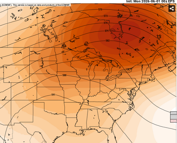
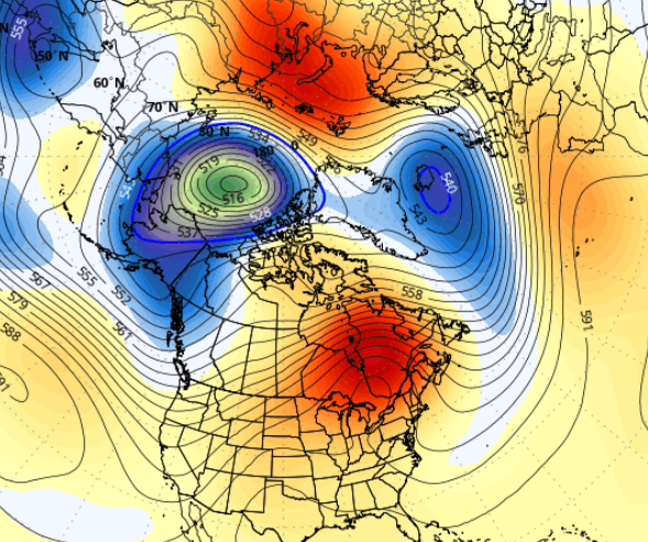
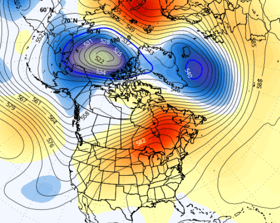
That all aside ... heat, where are we and what - What was once merely suggestive is now ... call it 'modestly' impressive. A signal for heat along 100 W/mid latitude continent. This has been in the ensemble clustered means for days -overnight is interesting. The simple version first, if and when this wave function collapses, the heat it containers will unleash and synoptically spread E with the prevailing vector. A hot time for day if not a heat wave. GFS ensemble mean centered on June 9 ... notice the +AO, too - The EPS and GEPs are in principle the same, with the same implications. The trough sag on the EC is legit... some 1/3 members refuse to admit to this [probable] evolution. The ridge NE of HA over the lower GOA is a favorable wave geometry for positive height anomaly around Michigan - heat wave for them... But the +AO/+NAO, ongoing, suggests that spreads E. I'm noticing even in the operational runs there are occasional Sonoran release signals, an implication whenever there is ridge-trough-ridge signal between 130W and 90W/mid latitudes. The operational versions are definitely toying with something of a warmer recovery... They are not taking advantage of the expansion this aloft gives them, but the polar branch appears to finally be decaying. That's precarious. At least in so far as what all this means for us N-E of the Mason Dixie, where we've been stuck in a troughy/cold purgatory for several weeks. As an side, despite the heat wave in May, May had trouble actually averaging above normal ... Logan ( ironically) did best in that regard, but interior climo sites were decimals of average, despite having days in the 90s. That means that the weight of the month was colder -statistics sometimes lie like that. Like Scott and I have noted several times in the past, we just go bonkers when we do get warm, and this is stressing/offsetting the perception of a cooler sensible journey.
-
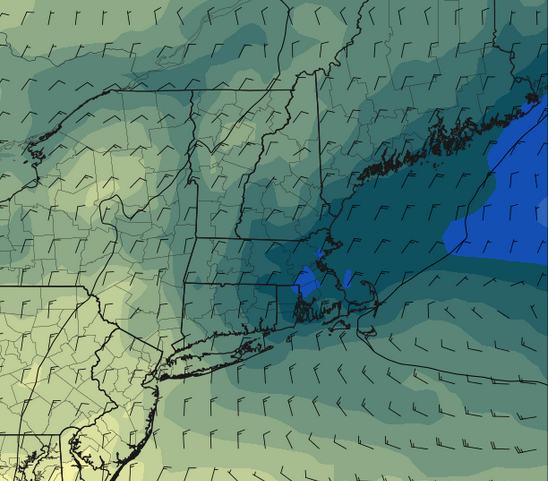
Actually Brian this is meteorologically interesting ( I guess...). I was looking at the GFS 850 mb charts more closely...you can see this pivoting S ... maybe it's like the opposite of yesterday. Nice through noon, than a piece of shit, today's the mirror of that.
-
we'll see... I suspect you're seeing the motion on sat, en masse going SW? but this is a legit cold insert behind the weakly defined low moving E of Cape Ann out there over the lower GOM. Already you can see strata streets filling in over Fryeburg and up along the steppe of Maine's interior. I'm curious to see how how much 'clearing' takes place. i'll give it to you though that the day is long and we spend longer time in apex solar so ... there'll be some thermodynamic processing
-
Yeah and looking at sfc obs together with morning sat loopage, there's a reinforcing diffused BD slipping SW through the region this early morning
-
twisted dark humor aside, we're in some kind of fractal this spring for this dog shit cold pooling (recurrent leitmotif). If it's not synoptic in scale, it's this shit above, even more so relative to our climate - which is bad enough for this in the first place.


