Kevin Reilly
-
Posts
3,401 -
Joined
-
Last visited
Content Type
Profiles
Blogs
Forums
American Weather
Media Demo
Store
Gallery
Everything posted by Kevin Reilly
-
My rain gauge must be cracked at home my sister in law checked it and it only had a half inch in it. I thought Media picked up 5” yesterday? Unless it wasn’t my part of Media perhaps Middletown. Was it that sporadic?
-
I am sorry I missed that still raining too guess my rain gauge will be over flowed when I get home? Meanwhile down here in Orlando Fl today windy gusts to 30-35 very dry air humidity levels today lower 40%’s behind Debby.
-
I am looking at the radar basically just light rain showers rotating around the center the heavy rain threat is far away from the center looks to me that Charleston and Savannah should be fine honestly. I looked at the web cam in Hilton Head there are people on the beach and the sun is even out. Charleston and Savannah are dry too with dry gounds. I will be checking into Charleston, SC on August 11th should be fine.
-
There is a boat load of dry air working around the bottom of Debby and pushing up behind her from the Southwest this could be a big deal in helping with limiting the heavy rain up in South Carolina outside of that one or two bands that set up to the north, northwest, and northeast of the decaying center.
-
Looks like it has stalled or possibly even drifting ESE the center that is.
-
Severe bands rotating through down here now in Lake Buena Vista
-
All calm down here although I’m pretty far from the storm in Lake Buena Vista. Expecting squalls after 1 pm or so into tomorrow morning. Meanwhile my friend 3 hours south 200 miles SSW of here getting hit pretty good and surge has begun on the Canal in Cape Coral 10 miles inland. I am however going to move my car away from the trees just in case. They are calling for tropical storm conditions with isolated tornadoes. 83 partly sunny here.
-
Looking at Satellites Debby is very symmetrical. Almost if you use your imagination it’s ready to pull everything to the center.
-
I’ve been saying kind of worried all things seem system go over 87-93 degree waters. I keep having Charlie 2004 and Ian 2023 in the back of my mind. Let’s see where we are in 5 to 6 hours.
-
100% agree with this and the warm waters remember Charlie and Ian DO NOT downplay this situation take it as a serious threat!
-
I’m checking in their driving up from Orlando Fl on August 11th hopefully the town is still there.
-
Yep swing and a miss where I’m at in Florida it’s coming on up after it’s done with Georgia and the Carolinas. Let it come we need it. Unfortunately our pattern has found many ways not to deliver. I’ll be driving behind it literally. Next stop Orlando to Charleston driving.
-
Waking up to sunny down here in Orlando. I’m not expecting too many impacts here? Don’t let your guard down up the coast with what probably will become Debby. What’s interesting too is I check into Charleston SC on August 11th. I guess I’ll be checking into the aftermath. We drove down from SE Pa hope the roads are passable in Georgia, SC, NC as I look at the models this morning.
-

2024 Atlantic Hurricane Season
Kevin Reilly replied to Stormchaserchuck1's topic in Tropical Headquarters
Waking up to sunny down here in Orlando. I’m not expecting too many impacts here? Don’t let your guard down up the coast with what probably will become Debby. What’s interesting too is I check into Charleston SC on August 11th. I guess I’ll be checking into the aftermath. We drove down from SE Pa hope the roads are passable in Georgia, SC, NC as I look at the models this morning. -
Waking up to sunny down here. Don’t let your guard down up the coast with what probably will become Debby. What’s interesting too is I check into Charleston SC on August 11th. I guess I’ll be checking into the aftermath. We drove down hope the roads are passable in Georgia, SC, NC as I look at the models this morning.

-
Hoping Media got some rain today? I’m down in Florida a state of emergency was just issued. Should be an interesting weekend down here.
-
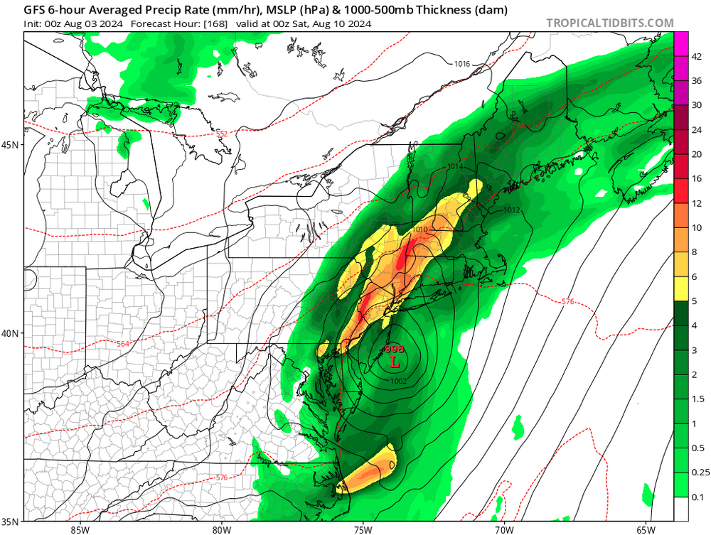
Two centers not colocated together
-
If I look at the GFS thinking the northern circulation is the one it’s latched on to we shall see in time.
-
Yep in Savanah Ga right now heading to Florida until August 11th. Water temp 89-92 along west coast.
-
Hey how about those thunderstorms today with hail that rocked the area how did that pan out?
-
2024 Atlantic Hurricane Season
Kevin Reilly replied to Stormchaserchuck1's topic in Tropical Headquarters
I think in regard to rain and tropical threats this year that this is just the beginning for SE Texas sorry to say. -
2024 Atlantic Hurricane Season
Kevin Reilly replied to Stormchaserchuck1's topic in Tropical Headquarters
I agree. I think the models showing a bit of something on August 1st to 6th is kind of a precursor or warning of what is to come. Call it a false start the active period but the real active period begins around August 10th. August 1st to 6th is an appetizer sort to say. -
Mowed the dusty grass here. I have not seen this type of dryness here since August and early September of 1999 or July of 1988 take your pick very dry. Also, anyone noticing the smoke today in the sky pretty evident. I think Sosa lost the ball in the white skies today at second base.
-
2024 Atlantic Hurricane Season
Kevin Reilly replied to Stormchaserchuck1's topic in Tropical Headquarters
6z gfs onboard for tracking first 10 days of August. I’ll be in Orlando August 1st to 11th then heading to Charleston SC so I’m watching this. I’ll be driving so just make sure I’m at full most of ride as needed. Driving down from SE Pa.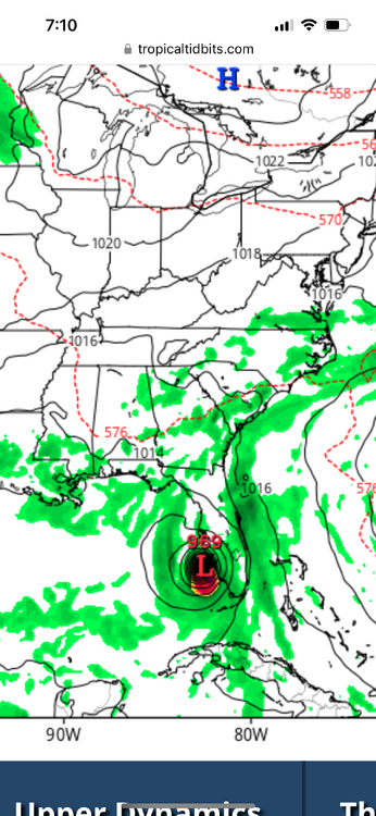
-
THATS where the Euro had development 0z run Wednesday however did lose it last nights run.