-
Posts
4,734 -
Joined
-
Last visited
Content Type
Profiles
Blogs
Forums
American Weather
Media Demo
Store
Gallery
Everything posted by Windspeed
-
Here is the most recent profile of GOM SSTs. Consider that Milton is currently reintensifying over a shallow shelf north of the Yucatán where immediate shallow layer SSTs are still ~29°C. Milton's core will move over regions of 30°C and slightly higher several times prior to landfall. Though there had been a PRE and a lot of storminess over these areas the past 24-36 hours, the thermal content near the surface simply isn't going to be an issue for Milton. It's the atmospheric dynamics at play and Milton's internal evolution of structure that will dictate its landfall intensity.
-
Based on the projected forward motion of Milton as it crosses the eastern GOM, the loop current is kind of an overrated feature. It's not going to be moving slow enough that depth of 26°C isotherm really matters. SSTs are pretty much 29°C near the surface for the remainder of its track and pushing 30°C over the shelf west of the Florida shoreline.
-
Eye continues to clear as evident in the ongoing temperature spike within the eye.
-
Nice post by Webb on Milton's structural evolution, EWRC overnight, and vorticity merger.
-
There's not really much to add. The evolution of Milton's structure over the past three hours speaks for itself. The next recon flight should be interesting.
-
Interesting maneuvering by recon on this last pass.
-

2024 Atlantic Hurricane Season
Windspeed replied to Stormchaserchuck1's topic in Tropical Headquarters
-
Recon is positioning for one more pass from the SW to NE quadrants.
-
Recon's last pass from SE to NW doesn't give much arguement of that strong outer band (which does show up on that pass) encircling the current eyewall. You can clearly see a rain rate spike and mild wind spike, but a similar rain rate and wind spike is not there on the northern or NW side of Milton's circulation. So perhaps we do not yet have a developed enough outer band or concentric feature to kick off a new EWRC yet. As such, we just have a strong eastern or southeast feeder band that may eventually encompass the eye later today. Let's see if this mission does one more pass. If not, we may just have to wait on the next recon, or perhaps we'll get a new MW pass later today.
-
Andy thinks another EWRC is about to commence based on the radar out of Cancun. Cannot deny that the appearance of Milton's structure shows a pretty sharp moat between the eastern outer band and the eyewall currently. But I am unsure if there is an outer wind spike at present or if that outer band is concentric around the entire eye with the northern half too distant/weak from the radar beam. We may just have to be patient for recon.
-
I think the issue we face for today and tonight is that Milton is embedded within an overall favorable environment that is condusive for reintensification. Milton's foward motion will be increasing while it is positoned in the right front entrance region of a strengthening 200 hPa jet streak over the SE CONUS. With SSTs remaining condusive and prior to shear being any overwhelming negative factor, Milton will be able to re-intensify or at least hold on to a high-end steady state of intensity. The mid-level steering flow is currently realigning into this upper mass-divergent jet streak. Can we say for sure dry air to the west doesn't get pushed into and entrained by the vortex? No, that could and hopefully will occur. But the favorable aspects of this synoptic setup still significantly outweigh the negatives over the next 24 hours. I expect any current appearance and a state that is temporary until reintensification occurs. If nothing else, a steady state should be maintained until a new EWRC evolves.
-
Be careful comparing previous storms, even Ian. The angle of approach and fetch by Milton is different than Ian. A storm somewhat paralleling the penninsula, and then hooking right may not be as significant as a major that is approaching from a more westerly positon. Also, though Ian had a bad surge, it moved inland at a slower motion. The southern circulation forced and piled water off the shallow shelf into the coast for a longer period of time. Milton, combined with its faster forward motion and lower SLP will be driving sea heights onto the shallow shelf and then pushing all that into the shoreline, bays, and inlets. Not every situation is the same. You hope for the best. But if Milton's windfield expands as modeled and given the already very low SLP, the fetch as it crosses from deeper water to shelf waters is the biggest issue. I hate to say this, but I think the surge will be worse than Ian and more expansive (as bad as that was). Perhaps a surge at Tampa Bay is mitigated if the circulation comes in south, but there is still a lot of highly developed residential and commercial real estate for several hundreds of miles south that will be inundated. But we are still too early to know for any certainty that Tampa Bay will be spared and probably won't know until tomorrow morning for a more defined point of landfall.
-
A few thoughts this morning. RE: Yucatán playing a role, I agree with @40/70 Benchmark that it did not. Milton's core and RMW is still very small even after its first (perhaps second as one may have occurred prior to the hyper period of RI yesterday morning). With a dominant 12-15nm wide eyewall and spiking eye temps, the old cloud debris of the old eye should be gone in a few more hours, and we will have further reintensification. The pressure is falling again, and I do think Milton will regain Category 5 intensity. It has very favorable conditons with an increasing jet streak today. SSTs are not an issue. A few more things about the most recent EWRC. 1) At 4-6nm in diameter and at sub-900 mb pressure, with such a micro RMW, any ERC is going to annihilate the pressure to wind gradiant relationship. So I don't think dry air played a role, Milton just needed time for the new, slightly larger vortex to catch up. That seems to be occurring now. 2) Though the RMW did expand back out a bit at 15nm or so, that is still a small core. The stage is set for another impressive bout of low pressure today. I'm not saying it will go sub 900 mb again, but it may flirt with the mid to low 905-910s. Sub 900s isn't unrealistic, however. The very cold cloudtops are a hint at this... 3) For significant RMW expansion and the forecasted large windfield, Milton will need to evolve a much larger eye. This, of course, to expand the large surge threat as is being modeled. There isn't in the way of overly strong outer bands yet, but by tonight, much of the TC models suggest this process will occur and lead to a much larger ERC on Wednesday as Milton crosses the eastern GOM. SSTs and upper atmospheric support will remain condusive for such an evolution of the core to occur.
-
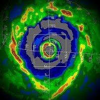
Radar out of Sabancuy, Mexico. At that distance, the beam height is high, but Milton's eyewall is very defined and intense.
-
22 hours from 55 kt TS to Cat 5 would have to be a record for the Atlantic.
-
11°C increase from eyewall to eye with hail/graupel. Pressure falling rapidly. No sign of outer band. With such a small RMW, if Milton gets into the 920s, we're most likely going to see a Category 5 status within a few more hours. It's certainly not done bottoming out. Edit: "Grapple"... lol... Also, RMW (radius of maximum wind), not VDM (vortex data message). Covering nights, and I need to sleep now, but you know why I'm not.
-
Always impressive to see the outline of the eyewall revealed by GLM lightning data as the vortex rapidly deepens.
-
The HAFS-B decides it doesn't particularly like the folks stationed at Isla Pérez on this run.
-
-
You knew it wouldn't take long based on imagery from MW and those impressive recon scans for the eye to start clearing out.
-
^ This x1000. As has been reiterated over the years, TCHP/OHC and their related maps are important for gauging MPI, but they're based on 26° isotherm depth and do not quantify upper atmospheric dynamics and storm motion for intensities. A slow-moving hurricane with average upper dynamics are aided greatly by depth of the 26°C isotherm. But immediate or near-to-surface temperature for fast moving systems are sufficient for an intense hurricane to avoid limitations of its own upwelling. Likewise, cooler than average upper tropospheric temperatures help to increase instability/atmospheric lift and lapse rates generated by slightly lower mean SSTs. Simply put, 28-29°C shallow layer SSTs should be plenty enough octane for Milton to reach even Category 5 strength if its internal structure doesn't get in the way of itself. It will be moving too fast for upwelling to be an issue now. And even if you account for a lack of deep content just north of the Yucatán, atmospheric conditions should remain favorable as the hurricane is crossing the loop current. However, Milton should have peaked in intensity by then and most likely will already have completed its first EWRC.
-
Ahh...the dreaded shrimp.
-
Yeah, remote sensing and in situ recon data all point to Milton being in the initial stage of rapid intensification that will most like go uninterrupted barring any structural changes. Any call on lowest pressure? I could see a 40-50 mb drop occurring by tomorrow night. Perhaps we can't rule out an even lower drop before outer banding begins to intensify and influence the core. I'm going to say 928 mb is not unrealistic by tomorrow evening.
-
Keeping a close eye on these fixes as well. The TC models want Milton's eye to lose .5 to .8 degrees of latitude over the next 18 to 24 hours as it passes south of Isla Pérez. Granted, that's not much, but it could have implications downstream on the location of ENE to NE turn. Edit: The exception is the HMON, which has a direct hit and landfall on Isla Pérez.
-
I thought there was active weather instrumentation maintained on Isla Pérez north of the Yucatán for Mexico, and data has been posted before, but I can not seem to find access to their data obs right now. Does anyone know where that is?


