-
Posts
4,734 -
Joined
-
Last visited
Content Type
Profiles
Blogs
Forums
American Weather
Media Demo
Store
Gallery
Everything posted by Windspeed
-
Thanks. Lol, got me by a few seconds.
-
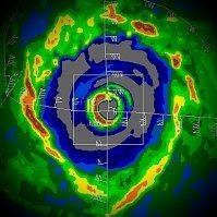
No, sir. We should eventually see a very clear and symmetrical eye as a major hurricane while favorable conditions allow.
-
Rapid deepening with strong outer bands guarantees an EWRC. The wind field is modeled to expand by virtually every TC model due to the structural evolution of Milton in 48-60 hours. Too much time remains between RI and landfall for outer banding to not do its job. Also, upper dynamics will support favorable/strong lift and instability on the north side of the circulation for an intense band to form away from the core. I normally use caution to make bold predictions when it comes to TCs, but a secondary outer wall forming and an expanding windfield is nearly a certainty here. This occurs prior to shallow shelf. As such, the fear of enhanced storm surge in the southern semicircle into landfall.
-
If the TC models even come within 75% of these crazy intensity outputs, the positive thing here is that it should scare the crap out of immediate coastal residents to get out and evacuate. Even if the storm weakens and the wind event is mitigated, the surge will have already been fetched and pushed onto the shallow shelf. As such, hopefully, there won't be anyone south of landfall point to experience it. This opposed to a rapidly intensifying storm near to landfall that surprises and catches people off guard. I'll take the bust on winds at the surface any day over the alternative of mass casualties due to drowning.
-
OPs (mainly ECMWF and GFS) are showing some interesting frontal and ST jet interaction near landfall, which appears to significantly tilt the mid-level vort and initiate transitioning of the surface vort. Despite the low pressure, perhaps that will mitigate wind damage if convective cells are confined more to the northern semicircle of the hurricane. Unfortunately, surge will have already been gained from fetch at high intensity and motion out of the central GOM and onto the shallow shelf, perhaps made worse by the somewhat perpendicular vector of flow towards the peninsula coastline. Granted, my comments are based on modeling alone, especially the look of the TC just prior to landfall on the main TC models (HAFS suite, HMON and HWRF). But keep in mind how this transition occurs IRL versus simulation and timing is too close for comfort. Also, any convection that really is there in what's left of the eyewall in the southern semicircle is likely to be fierce if the tight modeled gradient verifies.
-
We have a tropical storm still in its developmental phase, but obviously, with the official forecast, it's going to get chaotic. Major population center under threat and a lot of people talking about the current events, social, governmental, and civil-related topics. Keep the storm thread more meteorologically focused, please.
-
Well, so much for expecting a big swing in intensity every 6 hour run. The 06z GFS was similar to the 00z, but a tick north and a tad stronger.
-
Thanks. GEM was notably the slowest. It doesn't make landfall until around hour ~160.
-
If I am gauging the ensemble and op runs correctly, it appears a faster moving system comes in further north as it doesn't allow time for the mid-level steering flow to arc back ESE. A slower moving system gives time for the TC to get pushed further east than perhaps even ESE as the strong mid-level trough powers across the peninsula. You can even watch that flow evolve from the 850-400 hPa level and the mid-to-upper ST jet. That may explain why some of the slower modeling wants to bring this in down near Sarasota to even the Keys. Something to watch for with each modeling suite. Edit: I should have said "a faster moving system comes in further north as it doesn't allow time for the mid-level steering flow to arc back OUT OF THE W TO WNW."
-
GFS OP could just as easily swing back to a weak system on the 06z, and I will beat a dead horse and reiterate that we may see big swings between mere 6 hour runs due to the tightrope in which this system will have to walk to become a strong hurricane. That being said, it is a bit ridiculous that a global operational run intensifies a system to the brink of major hurricane strength within 72 hrs from TCG. I really hope that's just a random crap OP run.
-
Hrmm...
-
Looks like Leslie will be upgraded to a hurricane on the next advisory. AL132024 - Hurricane LESLIE per TAFB best track.
-
Notice how a few of the most northern EPS track simulate RI to a powerful major, then suddenly weakens the TC down to TS status prior to landfall. That's most likely due to the blasting mid-to-upper ST jet. An earlier developed TC gets ventilation and divergence aloft until the TC's core drifts too far north and gets decapitated. Interestingly, many of the middle tracks support a hurricane all the way into landfall (though granted not nearly as intense), which again likely has a lot to do with the core remaining just enough south of the shear axis to not get sheared off prior to landfall. Many possibilities on the table from this one, including the very small chance we see that first option: We get a huge scare from a rapidly intensifying hurricane that gets ripped completely apart prior to landfall. Much more likely scenario is a strong TS to minimal hurricane that makes it into landfall prior to significant weakening, but huge question marks on placement of TCG location, eventual track and proximity to shear axis values above 50 kts across the northern GOM. With the PRE and main system landfall, heavy rain and flash flooding is a higher risk, but attention has to be there for the wind and surge risk in case we get a stronger hurricane.
-
2024 Atlantic Hurricane Season
Windspeed replied to Stormchaserchuck1's topic in Tropical Headquarters
There's actually not much of a precedence in either the GOM or Caribbean, for that matter. Only a few TCs that come to mind that had an E to ENE track into landfall from the GOM or Caribbean that became strong. I recall Category 4 Lenny in November of 1999. Obviously, Wilma hooked ENE across the southern Florida Peninsula that originated out of the NW Caribbean. Opal developed out of the BOC and became a hurricane on Oct. 2nd, taking a NE track into the Panhandle. But overall, these types of tracks into the Peninsula are very rare. You would think it would happen more often, but the most likely reason I can think of why it doesn't is due to how tropical jet interaction works with these systems. Most often, if a TC or invest gains too much latitude, they get sheared off versus enhanced. Obviously, we do see a lot more frequent E to ENE tracks in the central ATL that become strong hurricanes. -
Ongoing issues with commercial trucks trying to navigate alternative routes and mountain roads, which end up not being able to handle the hairpin turns and steep inclines. GSNPS is closing 441 temporarily to alleviate the problem.
-

Summer-Fall 2024 Weather Disco Med/Long Range
Windspeed replied to John1122's topic in Tennessee Valley
Ongoing issues with commercial trucks trying to navigate alternative routes and mountain roads, which end up not being able to handle the hairpin turns and steep inclines. GSNPS is closing 441 temporarily to alleviate the problem.- 688 replies
-
- 1
-

-
- heat
- thunderstorms
- (and 7 more)
-
Damascus, VA, US-58 between there and Johnson Co., TN, completely gone.
-

Summer-Fall 2024 Weather Disco Med/Long Range
Windspeed replied to John1122's topic in Tennessee Valley
Damascus, VA, US58 between there and Johnson Co., TN, completely gone.- 688 replies
-
- heat
- thunderstorms
- (and 7 more)
-

2024 Atlantic Hurricane Season
Windspeed replied to Stormchaserchuck1's topic in Tropical Headquarters
Looks like there will be an associated PRE with this setup as well before the potential TC reaches the peninsula: -

2024 Atlantic Hurricane Season
Windspeed replied to Stormchaserchuck1's topic in Tropical Headquarters
RE: BOC system. The 12z ECMWF resolves a somewhat more concerning scenario for higher intensity because it keeps the core just far enough south of the shear axis as the system moves E to ENE. It does seem there will be a very fine line on how far north the system tracks versus intensity potential because shear will be very high (30-50+kt 850 to 250 hPa values) over the northern half of the GOM. It's difficult to know how exactly this plays out because even minute changes in proximity of flow above 500 hPa versus TC position will give large outcomes on strength. However, there is obviously increasing potential for a TC impact on the Florida Peninsula, even if it's still far more likely to be a heavy rain event. Should have an invest soon. This is one of those situations when we get an invest labeled, we see large swings in maximum TC intensity output for each 6-hr TC model run as tiny changes in TCG location, track and shear axis resolve huge differences in guidance. -
Helene's vortex was closed. The western eyewall was clearly weaker with broken convection and rapid rate of forward motion; however, Helene's eye was clear and warm. I do not doubt the in situ recon data that supported Category 4 intensity. The issues here are 1) A lopsided major hurricane at landfall; 2) The peak winds were localized to the eastern and southeastern quadrants based on storm motion and recon; 3) The storm chasers settled on Perry based on best guess to sample the center of eye. I believe Josh was just west of Perry. But this location would have been missed by Helene's worst winds that were off to the east and southeast. There's not much else to do here but speculate since the location was within a marshland reserve and forested area.
-
I expected MDR SSTs to produce a Cat 4/5 CV hurricane this season, just not in October. Crazy what Atlantic TCs can do when atmospheric conditions switch to favorable. I mean, obviously, we've seen numerous powerful CV majors over the years during peak September. It's just been a weird season. Beryl rolls off and explodes in late June, followed by three months of late intensfiers near land; then Atlantic environmental conditions finally improve, and the MDR looks like September 3rd, not October 3rd.
-
Rainy and windy. Gale warnings and definitely TS force gusts, perhaps some hurricane force gusts, but Helene would be far enough along in its post transition to have a spread out gradient by that point. Still, it is a hefty low pressure and windy for certain, but those folks aren't strangers to strong mid-latitudinal cyclones.
-
Major Hurricane Kirk will be moving over increasingly warm SSTs. It should cross over 29+ SSTs for several days, though, as the forecast calls for increasing shear by the weekend, its MPI should come down. Regardless, this is a powerful hurricane and should pack on the ACE while being fun to track without all the prior drama we've had to deal with this season. Barring some sharp hook into the Azores, Kirk should remain no threat to land.

