-
Posts
4,731 -
Joined
-
Last visited
Content Type
Profiles
Blogs
Forums
American Weather
Media Demo
Store
Gallery
Everything posted by Windspeed
-
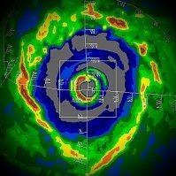
Good grief! Typhoon Kong-Rey is really living up to its name here, folks. The IKE on this thing must be insane. Deep intense ring of convection around a massive 55 nm eye with strong mesovorticies rotating around the inside of the eyewall. The sheer size of the low-level and mid-level vortex combined with such intensity is critical. It's just a different breed of TC in the WPAC, even if the size of this one is still kind of rare to be so strong. It's hard to fathom a TC this large being in the GOM. The storm surge alone would surpass 30 feet along the NGOM coast.
-

2024 Atlantic Hurricane Season
Windspeed replied to Stormchaserchuck1's topic in Tropical Headquarters
It's not unusual for a global operational run to miss resolving tropical cyclone genesis when that has yet to occur IRL, even during several days of repeated runs showing a TC. But the 12z GFS still has a TC making landfall in Haiti. But it is not good to focus on specifics like tracks and intensity with a chaotic pattern and big swings in motion. We don't even have an organized disturbance yet, much less a vortex, though we do have pressures beginning to fall that should lead to a surface trough developing. As such, convection is beginning to pop over the SW Caribbean. -
Yeah, the eye has continued to warm. SSTs are ~28°C under Kristy's core. Great enhancement with a strong ULAC aloft and low shear values; at 140 kts intensity, Kristy has been able to reach MPI.
-

2024 Atlantic Hurricane Season
Windspeed replied to Stormchaserchuck1's topic in Tropical Headquarters
-

2024 Atlantic Hurricane Season
Windspeed replied to Stormchaserchuck1's topic in Tropical Headquarters
https://bsky.app/profile/weathertiger.bsky.social/post/3l7773za4l22d -
Major Hurricane Kristy (former Nadine in the Caribbean) is cranking in the EPAC. ADT supports upper Category 4 intensity now. Might even push an MPI of 135 kts before any structural change, or EWRC can take over.
-

2024 Atlantic Hurricane Season
Windspeed replied to Stormchaserchuck1's topic in Tropical Headquarters
Yes, the pattern doesn't really support a phasing scenario that would pull a TC into the eastern seaboard. However, a Caribbean system might still impact Florida as it turns into the westerlies. Certainly, Central America, the Antilles and Bahamas could all be at risk depending on the initial and outcome steering layer. We have at least a week to iron out the details and watch how modeling resolves the interacting features. But overall, I'd rule out any CONUS threat beyond the Florida Peninsula. -

2024 Atlantic Hurricane Season
Windspeed replied to Stormchaserchuck1's topic in Tropical Headquarters
I agree with the above posts about the upcoming midrange signal. That pattern suggested by both ensemble suites, including as much agreement as you can expect given the lead time between all the operationals, is highly suggestive of WCARIB development next week. A lingering surface trough over the SW Caribbean interacts with a disturbance currently positoned in the ITCZ that slides across Venezuela. This times with an amplified ST jet over the MX->GOM->SE CONUS that builds a large ULAC over the disturbance. That's a very volatile atmospheric setup for instability; and given that surface pressures between Jamaica and Panama should be low for an extended period, I'd say that modeling is going to go on a rampage the remainder of the week with TCG next week. -
Probably was a Category 2 at landfall. The radar out of Guantanamo Bay had very intense echoes in the eastern and northern eyewall. Cloudtops were cooling, and the eye was clearing. SAR data suggests intensification into landfall; therefore, Oscar will be a good candidate for an upgrade in post analysis in the post-seasonal report.
-
Eastern eyewall is definitely cranking at the moment... Perhaps 3, maybe 4 hours at most? Also, Oscar's tiny core will probably collapse fairly rapidly right at landfall. The mountainous terrain should disrupt inflow with haste.
-

2024 Atlantic Hurricane Season
Windspeed replied to Stormchaserchuck1's topic in Tropical Headquarters
We have now reached 10 hurricanes on the season. Only 17 other seasons since official records began in 1851 reached double-digits. Granted, pre-satellite era years are underdone, and there are most likely TCs that unknowingly reached hurricane intensity. But based on the reanalysis of historical weather logs and shipping reports, this is what we get. 10: 1870, 1878, 1886, 1893, 1916, 1998, 2012, 2017, 2024 11: 1887, 1933, 1950, 1995 12: 1969, 2010 14: 2020 15: 2005 -
Yes, we may have just had a landfall. But the core is so tiny it's virtually impossible to tell via remote sensing. We'll have to see if there were any OBS to suggest as such in the ground.
-
I would imagine a scramble to get out incoming watches and warnings for the Turks and Caicos and an advisory package for the 11AM AST. This is about as close as you're ever going to see NHC forecasters caught with their pants down. lol...
-
Keep an eye on 11AM AST now.
-
It's a very tiny system, as you can clearly see on microwave. But we haven't had recon for 36 hours. Though San Juan radar suggested a developing mid-level circulation, yesterday, we didn't have any evidence of a westerly wind at the surface within the southern semicircle. But obviously, overnight, the satellite and some remote sensing imagery started to suggest this had spun up a tight vortex. I must admit I am a little surprised that the NHC waited until this morning's 8AM to begin escalating chances of development.
-
Good grief. This TC has a developing eyewall. D'oh!! This needs to be classified immediately. Land interaction is now in play for the Turks and Caicos Islands.
-
In the first view visible frames this morning, there is clearly low-level westerly flow to the cloud field. Highly suggestive of a closed surface vortex near the mid-level vorticity. Could definitely use a recon flight soon.
-
I know, right? This gets the Healthiest Tropical Blob of the Year (HTBY) award for 2024.
-
Just when everyone discards 94L to the compactor. That's an organizing mid-level vortex. A bit up in the mid-levels on the beam from San Juan, but it could be close to closing off at the surface. Shear is in the forecast, so I'm unsure how far a potential TC can intensify, but it does appear to be organizating in the short-term.
-
Dorian was also so close call. A 48-hour change in 590s dm heights prevented a 500+ billion disaster. Hard to imagine a 15nm Category 5 eyewall at MPI landfalling over some of the most expensive real estate in the US, then slowing turning NNW and riding the entire eastern shoreline as a weakened Category 1-2.
-

2024 Atlantic Hurricane Season
Windspeed replied to Stormchaserchuck1's topic in Tropical Headquarters
GFS ensembles try to resolve a system. Not much there on the Euro ensembles, however. -

2024 Atlantic Hurricane Season
Windspeed replied to Stormchaserchuck1's topic in Tropical Headquarters
GFS has TCG resolving in 72-78 hours east of Nicaragua. That's a significant bump up for the time frame here. We should start seeing a disturbance and convective activity in a few days if this is going to go down so quickly. -

2024 Atlantic Hurricane Season
Windspeed replied to Stormchaserchuck1's topic in Tropical Headquarters
Yeah, I added it. We've had hurricanes that have produced more numbers of tornadoes (both Ivan and even this year's Beryl comes to mind), and I'm not even sure that Helene will be in the top 5 for that matter. But a lot of Helene's tornadoes occurred as waterspouts out over open ocean and therefore were not as tracked/accounted for. Certainly, the number of SIG-tors by Helene is the most critical to yesterday's event. RE: Cost. Yes, unfortunately, I do think Helene will surpass Katrina as the most costly natural disaster in American history, even accounting for inflation. Though, perhaps that's difficult to determine in comparison to the Great 1906 San Francisco Earthquake. At least in modern times and estimates, it does look like it will surpass Katrina. -

2024 Atlantic Hurricane Season
Windspeed replied to Stormchaserchuck1's topic in Tropical Headquarters
ACE will be over 140 points heading into the second weekend of October. It's quite obvious now that if the Atlantic Basin had produced only a few hurricanes during the stretch of prolonged and below normal intraseasonal quiet, we would finish at hyperactive values. Granted, a hyperactive season is still possible given a few strong Caribbean hurricanes through November, and we have seen activity into November in recent years. However, it is more likely we will not hit the lofty preseason targets. We are, however, going to finish above normal. The ACE metric and total number of named storms do not necessarily weigh on how bad the season has been. The CONUS has experienced a nightmarish tropical cyclone season with five landfalling hurricanes. Six is the record (2020, 1985, and 1886). However, 2024 landfalls have been deadly and expensive. After Beryl devestated the Grenadines and impacted Jamaica and the Yucatán, it went on to produce notable damage in the Houston-Galveston metropolitan region. Francine caused significant flood damage in the western New Orleans metro. Helene, not withstanding significant surge impacts from Tampa to Steinhatchee, was among the worst inland wind and flooding TCs in American history and will no doubt prove to be the costliest TC on record because of it. Helene will also end up among the deadliest for the US due to the catastrophic events that unfolded in the southern Appalachians. Though Milton can be considered a very lucky impact, barely missing Tampa Bay to the south and avoiding a catastrophic landfall, it was still a powerful system that flooded coastal shoreline communities and has wreaked havoc inland across the peninsula with damaging winds in the Tampa, Pete and Sarasota metros; furthermore, inflicting significant damage to inland trees and power grid infrastructure, plus significant inland fresh water flooding. Estimates for the 2024 season's price tag may push a quarter of a trillion dollars and go down as the costliest season in US history. Edit: You know it's been a bad season when you overlook a hurricane landfall. I didn't even include Debby's impacts, which weren't insignificant, causing fresh water flooding from Sarasota County, Fl., to the central and northern Appalachians and areas in the Mid-Atlantic and eastern Ohio Valley. Debby also spawned an EF3 tornado in the Carolinas. Of course, the tornado impacts from Milton are still being assessed, but it's looking like it may have spawned numerous SIG-tors. I suppose I could go on and on, but it's clear this season has been an awful one for millions of US citizens and folks in the Caribbean. Hopefully, the worst is over, but there are signs in the midrange that suggest we may not yet be finished.


