-
Posts
4,734 -
Joined
-
Last visited
Content Type
Profiles
Blogs
Forums
American Weather
Media Demo
Store
Gallery
Everything posted by Windspeed
-
Major Hurricane Melissa - 892mb - 185mph Jamaica landfall
Windspeed replied to GaWx's topic in Tropical Headquarters
Ridiculous. Only a handfull of Atlantic hurricanes have been stronger than Melissa and we still have three or so hours to go. -

Major Hurricane Melissa - 892mb - 185mph Jamaica landfall
Windspeed replied to GaWx's topic in Tropical Headquarters
He's in a concrete villa. He will be fine. With daylight hours it should be intense footage. -

Major Hurricane Melissa - 892mb - 185mph Jamaica landfall
Windspeed replied to GaWx's topic in Tropical Headquarters
We may have landfall just after noon, perhaps by 1PM EDT. Trying to approximate this while considering that the forward motion is also slowly increasing as well. -

Major Hurricane Melissa - 892mb - 185mph Jamaica landfall
Windspeed replied to GaWx's topic in Tropical Headquarters
Imagery actually suggests that the diameter of the eye has increased since the merger. Now we have a deep ring of lighting as well. I hate to say this, but it looks like Melissa is undergoing another period of intensification. Certainly somewhat better than a steady-state. Recon will be, *ahem* interesting... -

Major Hurricane Melissa - 892mb - 185mph Jamaica landfall
Windspeed replied to GaWx's topic in Tropical Headquarters
Thank you! Glad Kevin was able to grab an image. Yeah, Melissa's core has been one of the most resilient I can remember since perhaps Dorian and Irma at such a high intensity. -

Major Hurricane Melissa - 892mb - 185mph Jamaica landfall
Windspeed replied to GaWx's topic in Tropical Headquarters
Also, Jamaica has already been getting pounded all night with that right front quad feeder band feeding off the central Caribbean. There appears to be a break in precip between the core and that wide, strong, convectively active feeder. That might help some, but totals are no doubt already adding up over the higher terrain to the central and eastern range. -

Major Hurricane Melissa - 892mb - 185mph Jamaica landfall
Windspeed replied to GaWx's topic in Tropical Headquarters
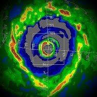
Jamaica's radar sites are not pulling down. So I jumped to the only other radar site I could find that has the core. This is the tower in Pilon, Cuba. It is quite long range so the echoes are weak from this distance. However, you can still make out Melissa's very symmetrical eyewall. Especially compared to any returns adjacent to it. To my eyes, there may be a moat on the SW backside, but I don't really make out any signs of an EWRC yet. We are running out of time for such to do any damage to the core. It would need to already be underway by now. I'm starting to feel like this is definitely going to be a strong Category 5 strike. -

Major Hurricane Melissa - 892mb - 185mph Jamaica landfall
Windspeed replied to GaWx's topic in Tropical Headquarters
It doesn't matter where he initially set up. He'll go to where he thinks he will punch the core. He always does. I am pretty sure he's relocating west. As for point of landfall, population distribution and characteristics, I highly recommend reading this paper in the Geneva journal of risk management. https://www.researchgate.net/publication/348943501_Poverty_and_hurricane_risk_exposure_in_Jamaica I will post this image from the paper below. As you can see, we certainly aren't in any sort of best case scenario if the eye comes ashore further west. About the only positive I can see right now is timing of landfall occurring during daylight hours so people taking shelter can visually see what the hell is unfolding, because it's going to be shear chaos where this core crosses over. -

Major Hurricane Melissa - 892mb - 185mph Jamaica landfall
Windspeed replied to GaWx's topic in Tropical Headquarters
I noticed that, and the NHC may take that data into consideration on their next advisory if Melissa's satellite presentation doesn't degrade. The TC may have finally leveled off, however. It's going to be a while before we have the next recon data, and Melissa may be at peak now. Edit: This is all really just meteorological geekdom. A few more millibars make no difference at this point. The hurricane is already in rare territory. -

2025 Atlantic Hurricane Season
Windspeed replied to BarryStantonGBP's topic in Tropical Headquarters
Melissa has now pushed us above average seasonal ACE for the date (117.1 vs 113.7) and will most likely push the Atlantic above seasonal average of 122.5 for the year by the time it dissipates. Granted, if you would have told me going into the season that we would experience three Category 5 hurricanes and only be around annual average mean ACE, I'd have laughed you off of the forum. It's been a weird season. Interestingly, all other basins are currently below their seasonal ACE values for the date as well. Though I suspect the EPAC will probably pump out a few more TCs to get above its seasonal ACE values before all is said and done. -

Major Hurricane Melissa - 892mb - 185mph Jamaica landfall
Windspeed replied to GaWx's topic in Tropical Headquarters
One final pass. Looks like it's going to be a N to S penetration before heading back to base. -

Major Hurricane Melissa - 892mb - 185mph Jamaica landfall
Windspeed replied to GaWx's topic in Tropical Headquarters
I think we might get one more pass NW to SE before they fly back to staging. The last dropsonde was 903 mb, which, based on trends and ongoing satellite appearance, is kind of critical here. I don't think Melissa has leveled off. It is unfortunate that we may not be at peak yet, and that may still occur between now and landfall. -

Major Hurricane Melissa - 892mb - 185mph Jamaica landfall
Windspeed replied to GaWx's topic in Tropical Headquarters
Melissa leveled off earlier ~906 mb. But I think we should be prepared that Melissa may be driving down pressure further now. The wider -90°C strong banding rings are suggestive of intensifying banding, but without any degradation of eye symmetry here or significant contraction, it's indicative of some mergers of the outer band into a portion of the inner eyewall. If that is the case, we may be looking at a sub 900 mb run tonight prior to landfall. -

Major Hurricane Melissa - 892mb - 185mph Jamaica landfall
Windspeed replied to GaWx's topic in Tropical Headquarters
My goodness... https://bsky.app/profile/jeremydehartwx.bsky.social/post/3m46sngepdc2r -

Major Hurricane Melissa - 892mb - 185mph Jamaica landfall
Windspeed replied to GaWx's topic in Tropical Headquarters
We can really hammer this home. Best case scenario is the trough lifting Melissa out fast. Actually, this track has unfolded better than some of the model runs a few days ago that had the slow down and drift west we are seeing this morning occurring just off the southern coast in much closer proximity before turning inland. Hopefully, Melissa's core won't spend too much time over the island on Tuesday. It will still be a catastrophic impact, and mudflows off the ridges and down into low-lying areas is the most dangerous aspect of the event. -

Major Hurricane Melissa - 892mb - 185mph Jamaica landfall
Windspeed replied to GaWx's topic in Tropical Headquarters
Dorian was embedded in higher background pressures. You have to take into account the position and surrounding environment. That's why we don't go by a strict pressure to wind chart. Also, the size of the vorticity's radius of maximum wind (RMI) matters as well. -

Major Hurricane Melissa - 892mb - 185mph Jamaica landfall
Windspeed replied to GaWx's topic in Tropical Headquarters
The reason I thought they were missing the NE eyewall a few posts ago is due to this. It appears they flew through the more eastern eyewall than the NE quadrant and might have even missed the center of the eye here. But then I had to remind myself of that pesky parallax positoning of the satellite image. -

Major Hurricane Melissa - 892mb - 185mph Jamaica landfall
Windspeed replied to GaWx's topic in Tropical Headquarters
910 extrap -

Major Hurricane Melissa - 892mb - 185mph Jamaica landfall
Windspeed replied to GaWx's topic in Tropical Headquarters
Recon may be positioning to make an east to west pass. I say that because their current flight path would miss the eye unless they turn due west. Nevermind. I don't know what I was looking at there. It is still a NE to SW pass. -

Major Hurricane Melissa - 892mb - 185mph Jamaica landfall
Windspeed replied to GaWx's topic in Tropical Headquarters
Most recent long-range radar scan. The eyewall remains uniform and intense. It does appear a concentric outer band is trying to form around the periphery of the eyewall. We still have 24-28 hours until landfall. That is plenty of time for an EWRC to begin. The forecast is for Melissa to be a Category 5 at landfall, but internal structural changes could still bring down that intensity to Category 4. But again, that is not necessarily a good thing for the island, as the windfield would expand east towards higher populated areas. I actually do think the intensity will fluctuate down by landfall as I still think outer banding will get its act together and weaken the small eye by tonight. It is very difficult for a high-end TC like this to maintain that intensity for that many hours without fluctuations. Time will tell. -

Major Hurricane Melissa - 892mb - 185mph Jamaica landfall
Windspeed replied to GaWx's topic in Tropical Headquarters
Looks like we are around 30 hours from landfall give or take a few depending on timing of the trough influenced deep layer southerly flow. We should start to see northward motion begin by midday or noon'ish. Timing on this is critical for the eventual landfall point. -

Major Hurricane Melissa - 892mb - 185mph Jamaica landfall
Windspeed replied to GaWx's topic in Tropical Headquarters
The trough is also moving into influence which can begin to affect symmetry and convection on the periphery of the TC, including the outflow channels. Otherwise, Melissa's core is about as textbook as it gets for a powerful Atlantic Caribbean hurricane. Current appearance kind of reminds me of Matthew. -

Major Hurricane Melissa - 892mb - 185mph Jamaica landfall
Windspeed replied to GaWx's topic in Tropical Headquarters
Nothing to say, really. Wilma had recon support for its peak. -

Major Hurricane Melissa - 892mb - 185mph Jamaica landfall
Windspeed replied to GaWx's topic in Tropical Headquarters
Let me get it out of the way first. Melissa is definitely a Category 5 right now based on initial recon. But clearly there is something to be said about inflated ADT numbers due to CT temperatures. ADT is spitting out sub 900 hPa estimates and we're no where near that. I think while recon is out there they will sample in the 910s range before they leave. But we're going to start having to curb CT temps based on background characteristics of the Autumn tropopause height. A ring of sub -80 to -90°C is still impressive regardless of date. But it is becoming quite apparent that given the later months (late Oct, Nov., Dec.) that the tropopause height in the deep tropics allows tops to get colder than the Summer and late Summer months. It inflates dvorak numbers. We have had suspicions for years that WPAC deep tropic super typhoons may have been over estimated. Again, it doesn't take away from the fact highest-end TCs are Category 5s on the Saffir Simpson. But the later the seasonal date, ADT is estimating too low a pressure. 895 versus operational ~20 hPa off is ridiculous. -

Major Hurricane Melissa - 892mb - 185mph Jamaica landfall
Windspeed replied to GaWx's topic in Tropical Headquarters
Two insane IR loops with lightning data for posterity. New IR and the older AVN. No doubt about it, Melissa's eyewall is absolutely cranking at present.

