-
Posts
4,733 -
Joined
-
Last visited
Content Type
Profiles
Blogs
Forums
American Weather
Media Demo
Store
Gallery
Everything posted by Windspeed
-
Major Hurricane Melissa - 892mb - 185mph Jamaica landfall
Windspeed replied to GaWx's topic in Tropical Headquarters
The url on extwitter only showed the damage around those coordinates. Here's the main site you can use to zoom through what has been mapped so far. https://storms.ngs.noaa.gov/storms/melissa/index.html -

Major Hurricane Melissa - 892mb - 185mph Jamaica landfall
Windspeed replied to GaWx's topic in Tropical Headquarters
Melissa is still packing quite a punch while transitioning. -

Major Hurricane Melissa - 892mb - 185mph Jamaica landfall
Windspeed replied to GaWx's topic in Tropical Headquarters
It's probably the beginnings of being overtaken by the right front quadrant of the eyewall. Josh even stated it was before peak, and they were forced to bolt the doors, as it got much worse. I'd guess what you're seeing there is somewhere between 70 to 80 kts sustained with perhaps a much higher gust towards the end. Edit: Actually, those gusts towards the end may have actually been an increase in the sustained wind. So, again, guessing here, 70-80 kts sustained in the first bit there and then an increase to 100-110 kts towards the end. It's hard to be sure, and I am just going on visual cues from a lot of these videos over the years (which still means squat). -

Major Hurricane Melissa - 892mb - 185mph Jamaica landfall
Windspeed replied to GaWx's topic in Tropical Headquarters
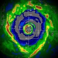
Huge thanks to Brian McNoldy at the Rosenstiel School of Ocean and Atmospheric Science at Miami for editing the full loops together for which I sourced these. I am posting these for posterity. Rarely do we have radar loops that show full eyewall mergers instead of eyewall replacement cycles. I will post both the short range and long range. Keep in mind the short range has limited/degraded echoes due to distance. But you can still make out the moat and concentric outer band/eyewall that was organizing in Melissa prior to the inner eyewall becoming dominant and absorbing them. The only other intense hurricane that we have radar evidence of this phenomenon is Irma prior to its landfall in the Lesser Antilles. There is much to be learned about these type of events and how they occur. Most likely, when environmental conditons are near to perfect/pristine and an inner eyewall reaches a certain degree of stability, it will not succumb to outer concentric banding, but pull those bands in and absorb them. As we can see Melissa do in these loops, the dominant eyewall becomes extremely intense after the final merger before it goes on to become a sub 900 hPa hurricane. There is probably a doctorial degree for someone here. It just requires extensive research. Short range: Long range: -

Major Hurricane Melissa - 892mb - 185mph Jamaica landfall
Windspeed replied to GaWx's topic in Tropical Headquarters
Ok, hrmm... I might be getting some of his old footage mixed up. I think I'm confusing that with when Reynolds was chasing with him. -

Major Hurricane Melissa - 892mb - 185mph Jamaica landfall
Windspeed replied to GaWx's topic in Tropical Headquarters
I think what you are describing was when Super Typhoon Haiyan made landfall near Tacloban, Philippines. Come to think of it, that means Josh has been in the most intense Pacific landfall and the most intense Atlantic landfall in the satellite era. -

2025 Atlantic Hurricane Season
Windspeed replied to BarryStantonGBP's topic in Tropical Headquarters
We probably aren't done. A SW Caribbean system isn't uncommon for November. Also a few subtropical and even a purely tropical system over the central Atlantic. There are still regions of decent SSTs out there east of Bermuda and south of the Azores. Upper tropospheric temperatures are getting colder, and it doesn't take much beyond 26-27°C SSTs to drive instability with a TC reorganizing out of a cutoff trough. We see a decent system like that every other year in November. I do not forsee any more ACE machines like Melissa, however. -

Major Hurricane Melissa - 892mb - 185mph Jamaica landfall
Windspeed replied to GaWx's topic in Tropical Headquarters
I would expect the mountainous terrain of Eastern Cuba to rip up the low-level vorticity quite a bit here. Might not drop below hurricane intensity, but that combined with increasing shear, I doubt Melissa will be able to regain major status again prior to any impact on Bermuda. -

Major Hurricane Melissa - 892mb - 185mph Jamaica landfall
Windspeed replied to GaWx's topic in Tropical Headquarters
The northern eyewall is now onshore. -

Major Hurricane Melissa - 892mb - 185mph Jamaica landfall
Windspeed replied to GaWx's topic in Tropical Headquarters
Hopefully, they will stay out of the southeastern quadrant of the eyewall. Based on radar motion, they should miss it to their west. The terrain at the coast is rather rugged west of Santiago, so surge isn't as much a problem there. But Santiago proper has the harbor and low-lying area. They probably will get some surge, but not as bad as actually taking a hit from within eyewall. Melissa is also moving at a pretty decent clip now, so hopefully inland flooding off of the higher elevations won't compound the issue. -

Major Hurricane Melissa - 892mb - 185mph Jamaica landfall
Windspeed replied to GaWx's topic in Tropical Headquarters
Dropped a category, I see. I figured they'd at least hold at a 4 since the satellite appearance had recovered this evening. But a few knots difference is paltry. -

Major Hurricane Melissa - 892mb - 185mph Jamaica landfall
Windspeed replied to GaWx's topic in Tropical Headquarters
Trying to adjust and pinpoint motion to landfall. Barring any wobbles, it looks like the center will cross somewhere directly between Chivrico and Santiago. There is a small community on route 20 located there with an icon on the coast named Playa Aserradero. Not sure if anyone is familiar with the coastal region there. -

Major Hurricane Melissa - 892mb - 185mph Jamaica landfall
Windspeed replied to GaWx's topic in Tropical Headquarters
Perhaps two to three hours to landfall based on radar. -

Major Hurricane Melissa - 892mb - 185mph Jamaica landfall
Windspeed replied to GaWx's topic in Tropical Headquarters
VHT bursting in the northern eyewall. -

Major Hurricane Melissa - 892mb - 185mph Jamaica landfall
Windspeed replied to GaWx's topic in Tropical Headquarters
Chivrico is a town that might get a direct hit. It's west of Santiago on coastal route 20. It's located at -76.4 W and that looks about where the eye will come ashore. Santiago should be just far enough east to stay out of the eyewall. Fortunately, the location around Chivrico is not as prone to surge. Melissa will be mostly a wind event and hopefully it's gaining enough forward speed to mitigate flash flooding from torrential rain. -

Major Hurricane Melissa - 892mb - 185mph Jamaica landfall
Windspeed replied to GaWx's topic in Tropical Headquarters
Impressive. -

Major Hurricane Melissa - 892mb - 185mph Jamaica landfall
Windspeed replied to GaWx's topic in Tropical Headquarters
Really impressed by how well Melissa's mid level vortex held together and how fast the eyewall is reorganizing. It's not got a lot of time before landfall in Cuba, but it has incredible upper level support and obviously high SSTs to reintensify some in short order. At least maintain current intensity. Should be a Category 4 strike. -

Major Hurricane Melissa - 892mb - 185mph Jamaica landfall
Windspeed replied to GaWx's topic in Tropical Headquarters
Yes. Very warm deep down. *Barry White voice*.... But seriously, deepest 26°C isotherm in the Atlantic is consistently in the western Caribbean around Jamaica and the Caymans. -

Major Hurricane Melissa - 892mb - 185mph Jamaica landfall
Windspeed replied to GaWx's topic in Tropical Headquarters
I can't post an image right now, but the low-level cloud swirl pattern near the surface inside the eye of Melissa right now is very indicative of multiple (at least five or six) large mesovorticies rotating around the eye. If that persists through landfall, pretty much any location inside the eyewall, regardless of quadrant, is going to get wrecked. -

Major Hurricane Melissa - 892mb - 185mph Jamaica landfall
Windspeed replied to GaWx's topic in Tropical Headquarters
Josh has instruments staged. -

Major Hurricane Melissa - 892mb - 185mph Jamaica landfall
Windspeed replied to GaWx's topic in Tropical Headquarters
They may be filming and taking additional dropsonde data. This is getting into historical territory, considering it's going to landfall at this intensity. -

Major Hurricane Melissa - 892mb - 185mph Jamaica landfall
Windspeed replied to GaWx's topic in Tropical Headquarters
Waiting on the dropsonde. -

Major Hurricane Melissa - 892mb - 185mph Jamaica landfall
Windspeed replied to GaWx's topic in Tropical Headquarters
Jamaica doesn't really have much of a shallow shelf. Heat content is high at depth not far from the shore. A positive is that this mitigates surge to the harbors and bays. Still probably looking at 13 to 15 ft somewhere where the SE eyewall comes ashore. -

Major Hurricane Melissa - 892mb - 185mph Jamaica landfall
Windspeed replied to GaWx's topic in Tropical Headquarters
Yeah, I won't disagree. Motion is gaining. Perhaps just inside of three hours. -

Major Hurricane Melissa - 892mb - 185mph Jamaica landfall
Windspeed replied to GaWx's topic in Tropical Headquarters
Ridiculous. Only a handfull of Atlantic hurricanes have been stronger than Melissa and we still have three or so hours to go.

