-
Posts
4,733 -
Joined
-
Last visited
Content Type
Profiles
Blogs
Forums
American Weather
Media Demo
Store
Gallery
Everything posted by Windspeed
-

2024 Atlantic Hurricane Season
Windspeed replied to Stormchaserchuck1's topic in Tropical Headquarters
Yeah, I added it. We've had hurricanes that have produced more numbers of tornadoes (both Ivan and even this year's Beryl comes to mind), and I'm not even sure that Helene will be in the top 5 for that matter. But a lot of Helene's tornadoes occurred as waterspouts out over open ocean and therefore were not as tracked/accounted for. Certainly, the number of SIG-tors by Helene is the most critical to yesterday's event. RE: Cost. Yes, unfortunately, I do think Helene will surpass Katrina as the most costly natural disaster in American history, even accounting for inflation. Though, perhaps that's difficult to determine in comparison to the Great 1906 San Francisco Earthquake. At least in modern times and estimates, it does look like it will surpass Katrina. -

2024 Atlantic Hurricane Season
Windspeed replied to Stormchaserchuck1's topic in Tropical Headquarters
ACE will be over 140 points heading into the second weekend of October. It's quite obvious now that if the Atlantic Basin had produced only a few hurricanes during the stretch of prolonged and below normal intraseasonal quiet, we would finish at hyperactive values. Granted, a hyperactive season is still possible given a few strong Caribbean hurricanes through November, and we have seen activity into November in recent years. However, it is more likely we will not hit the lofty preseason targets. We are, however, going to finish above normal. The ACE metric and total number of named storms do not necessarily weigh on how bad the season has been. The CONUS has experienced a nightmarish tropical cyclone season with five landfalling hurricanes. Six is the record (2020, 1985, and 1886). However, 2024 landfalls have been deadly and expensive. After Beryl devestated the Grenadines and impacted Jamaica and the Yucatán, it went on to produce notable damage in the Houston-Galveston metropolitan region. Francine caused significant flood damage in the western New Orleans metro. Helene, not withstanding significant surge impacts from Tampa to Steinhatchee, was among the worst inland wind and flooding TCs in American history and will no doubt prove to be the costliest TC on record because of it. Helene will also end up among the deadliest for the US due to the catastrophic events that unfolded in the southern Appalachians. Though Milton can be considered a very lucky impact, barely missing Tampa Bay to the south and avoiding a catastrophic landfall, it was still a powerful system that flooded coastal shoreline communities and has wreaked havoc inland across the peninsula with damaging winds in the Tampa, Pete and Sarasota metros; furthermore, inflicting significant damage to inland trees and power grid infrastructure, plus significant inland fresh water flooding. Estimates for the 2024 season's price tag may push a quarter of a trillion dollars and go down as the costliest season in US history. Edit: You know it's been a bad season when you overlook a hurricane landfall. I didn't even include Debby's impacts, which weren't insignificant, causing fresh water flooding from Sarasota County, Fl., to the central and northern Appalachians and areas in the Mid-Atlantic and eastern Ohio Valley. Debby also spawned an EF3 tornado in the Carolinas. Of course, the tornado impacts from Milton are still being assessed, but it's looking like it may have spawned numerous SIG-tors. I suppose I could go on and on, but it's clear this season has been an awful one for millions of US citizens and folks in the Caribbean. Hopefully, the worst is over, but there are signs in the midrange that suggest we may not yet be finished. -

2024 Atlantic Hurricane Season
Windspeed replied to Stormchaserchuck1's topic in Tropical Headquarters
Too far into the midrange to even bother right now. Let's give it 3 to 4 more days and see if something is still trying to resolve on modeling in the NW Caribbean. -
Leslie: "Hey! Why'd everyone forget about me?!"
-
Wow... Here is an excellent example of strong building code for wind. Obviously built for strong hurricanes, but held up during a strong tornado.
-
Time for the worst surge push is now with intense, westerly, and northwesterly wind directions peaking.
-
Strong backside winds should be hitting the Sarasota metro and all of the coastal communities south along the shoreline now.
-
RE: Punta Gorda and Port Charlotte surge...
-
Surge starting to move into Venice...
-
Should be new low pressure records by Milton for many of these communites. https://www.twitter.com.com/DRmetwatch/status/1844170494200959046?t=s-4X4kBTGpS6uLJioL3dIQ&s=19
-
-
RE: Sustained winds and gusts enhanced by the low-level jet. This region should be quite fierce through the night post-landfall as transition continues. I do believe this will orient itself to bring the highest wind perpendicular into Sarasota, Laurel, Venice, and North Port on the southern semicircle of the circulation where the worst will be seen for surge impacts. This will, unfortunately, coincide with higher tide.
-
Be cautious of idiots reposting tornado videos on SM from old tornado outbreaks. I just got fooled myself.
-
As bad as the inland tornado outbreak has been, I'm afraid the surge is still going to be the biggest disaster with Milton. Most of us knew the timing of landfall would coincide with a degraded core and transition, but the sea heights aren't just going to magically disappear. Sea height and fetch has already been acquired, and areas south of the circulation will be inundated. We don't need a thick/intense southern eyewall band either. Strong surface winds perpendicular to the peninsula shoreline will be aided by the low-level jet to push the fetch onshore south of Milton's circulation center. The surge threat is high for a reason regardless of landfall intensity and why evacuations were needed.
-
The HAFS models have been excellent simulating the interaction with front, trough, mid-to-upper jet, and its transitioning evolution with these features. Milton's current structure at this point just prior to landfall is very similar to their simulated structures for several days runs. Now we watch for the SLP enhanced surge aided by the expanding windfield. We also watch for Milton's southern circulation to be aided by the ST jet and potential sting jet driven westerly winds, which may enhance low-level winds in shoving the surge on the shelf inland.
-
-
Dropsonde was 910 mb at 14 kts.
-
EXTRAP 912.6 mb
-
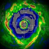
Since Key West Radar is just barely picking up the eastern eyewall, here is a zoom in of the last 15 scans or so from the radar out of La Bajada, Cuba. Here is the most recent scan. Not at PC and my phone is being a pain to upscale the gif resolution, so here...
-
lol.. This hits too close to home.
- 536 replies
-
- 15
-

-

-

-
It looks like the strong eastern outer band from earlier this evening has merged with the eastern eyewall, and now we have a large feeder spiraling around from the NW into the southern semicircle of a dominant eyewall. Perhaps it was a partial EWRC or just a merger, but recent recon is no longer finding a double wind maxima that is concentric. As such, Milton may begin restrengthening again through the morning hours. The CDO has actually cooled again the past few hours, and the eye is warming as well..
-
SW quadrant of the CDO might have trended warmer briefly, but cloudtops are cooling again. Here's both AVN and enhanced colorized for your eyes.
-
Even without waiting on recon, the NHC could easily re-upgrade Milton to Category 5 for the 4PM CDT/5PM EDT advisory. Though recon is descending to operational altitude, the forecaster has all of the satellite intensity estimate support to at least bump it up to 160-165. ADT supports ~150 kts even if they went much more conservative than that.
-
I don't know if this was shared yesterday or last night, but to say Milton's high-end intensity on an eastward motion is anomolous is quite an understatement. It would have been an anomaly as a Category 4. But for it to have attained Category 5 while moving ESE had never been seen before in HURDAT records.
-
Here is the most recent profile of GOM SSTs. Consider that Milton is currently reintensifying over a shallow shelf north of the Yucatán where immediate shallow layer SSTs are still ~29°C. Milton's core will move over regions of 30°C and slightly higher several times prior to landfall. Though there had been a PRE and a lot of storminess over these areas the past 24-36 hours, the thermal content near the surface simply isn't going to be an issue for Milton. It's the atmospheric dynamics at play and Milton's internal evolution of structure that will dictate its landfall intensity.


