-
Posts
4,734 -
Joined
-
Last visited
Content Type
Profiles
Blogs
Forums
American Weather
Media Demo
Store
Gallery
Everything posted by Windspeed
-
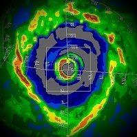
Eye clearing out a bit right at landfall. Nice convective burst going up over the NE quadrant. Probably too late to correspond to much of a pressure fall, but the deepening convection moving over land may translate to wind gusts mixing down with more force for places like Houma, Amelia and Morgan City as the eyewall passes over.
-
2024 Atlantic Hurricane Season
Windspeed replied to Stormchaserchuck1's topic in Tropical Headquarters
I am not trying to be argumentative in my response here, but I am lost on any correlation, much less causation with respect to sunspot activity and solar influences as inhibiting factors for cyclogenesis. During the same long-duration interseasonal quiet stretch in the Atlantic basin, we saw active stretches in the western and eastern Pacific basins. Solar influences should not discriminate between bodies of water. We have plenty of evidence of phenomenon contained within the troposphere to hypothesize why the Atlantic has struggled versus the WPAC and EPAC. Greater stability across the MDR due to +2-3°C warmer tropopause is among the evidence. But attributing that to sunspot activity seems more of a stretch than SPH placement, MJO, and meridional SSTs negative feedback to counter atmospheric lift versus subsidence. -
At present, the eye is easily discerned on visible satellite. The structure represents what we are seeing on radar. The more intense echoes of the north and western eyewall is where the deepest convection persists on satellite.
-

2024 Atlantic Hurricane Season
Windspeed replied to Stormchaserchuck1's topic in Tropical Headquarters
94L grabs the eye due to a vigorous exposed mesoconvective vortex (MCV) left spinning in the mid levels. That feature is exposed, and though easy to see on visible, associated convection is waning. I'm more interested in 92L. Persistent convection may eventually allow its mid level circulation to drill down. There is notable westerly flow to the low-level cloud motion south of the wave axis. In short, I'm not really impressed by either, and both systems lack model support. We'll see if 92L can get its act together. It could still be a threat to the NE Antilles if it does develop. -

2024 Atlantic Hurricane Season
Windspeed replied to Stormchaserchuck1's topic in Tropical Headquarters
NHC will initiate advisories on AL072024 or TD07 at 11AM AST. This was formerly Invest 93L near the Cabo Verdes. I don't think it warrants a new thread as it is too far into the eastern MDR and shouldn't be any near-term threat to land. Any light discussion will be fine here in the main thread. Modeling consense is for the TC to move into the central Atlantic into the midrange. -
Francine is following the script here. I do not expect any surprises. As has been much discussed, with mid-level flow tilting the vortex and advecting in pockets of dry continental airmass into the circulation, any further strengthening should be held in check. Pressure falls have leveled off and might even be rising some now. I wouldn't be surprised if the core weakens slightly prior to landfall. Obviously, flash flooding and surge are the prominent dangers here. I don't think sustained winds or gusts will be more than what seasoned Louisianans are able to handle. Not downplaying, it's still a hurricane. But this region has seen much worse in previous years.
-
The potential for arid stable airmass due to flow off the Mexican landmass is going to be something that Francine (or any TC regardless of year in this location) has to deal with. The steering layer is no longer easterly but from an arid source. That being said, Francine does presently have a nice structure with a healthy spiral band. If a core does complete into an eyewall tonight, more significant intensification can ensue. That would allow Francine to better shield itself off from the arid southwesterly steering flow as the TC turns NE within it.
-
They're not going to forecast a strong hurricane with several key variables being uncertain. Genesis has yet to occur. The phasing of the frontal low and the tropical surface low is still evolving, and a broader circulation could prolong development prior to any potential period of RI. Even if the upper-level flow looks favorable, mid-level flow could advect an arid airmass into the circulation out of Mexico/Texas prior to the core becoming dominant to shield itself. I do think this becomes a hurricane as it has enough time over high heat content. But I would be reluctant to forecast a major. Of course, now that I have said that, it will go full Opal thanks to Murphy's Law.
-

2024 Atlantic Hurricane Season
Windspeed replied to Stormchaserchuck1's topic in Tropical Headquarters
While much of the focus is on 91L/GOM system potential, as it should be, it may be time to start looking out into the MDR again. A disturbance has been designated 92L and is forecast to develop with good modeling support. As such, no surprise that the environmental state in the central MDR where this invest is located has improved significantly since the abnormally long interseasonal quiet period. 500 mb ridging across the north Atlantic is forecast to strengthen into the midrange, which should turn a hypothetical TC into an easterly steering layer. Can't rule out the NE Leewards, so we'll need to keep tabs on this system. Later into the long-range, there are too many unknowns for CONUS consideration. However, in the least, chances favor the development of a long-tracking MDR TC here and a potential ACE machine. -
Considering the numerous videos floating around on SM showing direct hits or close calls by flying debris unleashed by extreme winds on pedestrians, motorists and especially motorcyclists, I am left to wonder at how little these populaces disregard official warnings (or the lack thereof) to protect life and property. For all of the flak Americans get for riding out TCs, at least most of us heed warnings and stay sheltered. Another thought that crosses my mind is even more sobering. The struggle to keep a job for basic survival forces folks to risk life and limb. People can bitch and moan at the disruption a TC will bring to a region, but I am very relieved and proud that we have the societal structure and system of government in place to not only protect our citizens, but help them manage the survival part so they aren't forced by some shitty corporation to either bleed or starve.
-
Yagi continues to re-intensify and is now a Category 4 equivalent as explosive convection with HTs wrap the eye. Dire situation unfolding. Densely populated region at or below 2.5 meters (8 feet) -- essentially infrastructure built upon a river delta. The shallow gulf combined with shape of the coastline within the northern half of the circulation may funnel surge into these low-lying urban areas.
-
Yagi may be the big bad TC of 2024. That's not to downplay Shanshan's flooding impacts to Japan. Yagi has already caused severe flooding in the Philippines, smacked a densely populated city (Haikou) at Category 3+ intensity, and appears to have reintensified now prior to densely populated port cities in northern Vietnam. I can not recall a typhoon ever this strong impacting the Haiphong and Ha Long metropolitan regions in the satellite era. I am worried about potential storm surge up the estuaries there. Yagi may have been moving just slow enough to regain fetch in the Gulf of Tonkin.
-

2024 Atlantic Hurricane Season
Windspeed replied to Stormchaserchuck1's topic in Tropical Headquarters
Klotzbach weighs in again. -

2024 Atlantic Hurricane Season
Windspeed replied to Stormchaserchuck1's topic in Tropical Headquarters
Fair enough. I think we're all just a bit stressed trying to resolve what is going on versus the 20-25% failure mode. What factors are essentially countering other overwhelming favorable data points. Additionally, all hell could break loose in two weeks. We get complacency. Peak merely got delayed until mid-to-late September this year when all these countering factors subside. -

2024 Atlantic Hurricane Season
Windspeed replied to Stormchaserchuck1's topic in Tropical Headquarters
If I put you on the spot, well, you just made a post inquiring pros and cons about stepping away from the pack. So without empirical datum, you just played devils advocate and went with average numbers knowing if a 20-25% failure rate of climate precursors resolves, you are sailing to victory and looking quite brilliant and bold. lol... I appreciate the honesty versus jumping on the WAM strength/OS Index/Tonga (*barf*)/+NAO etc., etc... things we are trying to resolve in situ. I should also point out that you can still have a hyperactive season and only have 13 named storms based on metrics being ACE. Granted, that means the insanity of nearly all TCs being long-lived hurricanes or powerful majors. At any rate, I digress. I am pretty sure we know what you meant by hyperactive. -

2024 Atlantic Hurricane Season
Windspeed replied to Stormchaserchuck1's topic in Tropical Headquarters
Better yet, what was your reasoning in only going with 13 named storms in the face of overwhelming model and climate parameter support for a hyperactive season? I mean, you're sharing your numbers while knowing full well the majority of the best TC climatologists on the planet are scrambling for answers. 13 named storms is barely average. -

2024 Atlantic Hurricane Season
Windspeed replied to Stormchaserchuck1's topic in Tropical Headquarters
Welp... -

2024 Atlantic Hurricane Season
Windspeed replied to Stormchaserchuck1's topic in Tropical Headquarters
The MDR wave from last week's big AEW is gaining a robust convective envelope tonight. It's worth watching just to see if it pulls off some quick development through late week. There is an upper trough that is modeled to amplify north of the Lesser Antilles in 3-4 days that will likely impede the system with strong shear regardless. But in the meantime, perhaps it can grab a name and end the drought. -

2024 Atlantic Hurricane Season
Windspeed replied to Stormchaserchuck1's topic in Tropical Headquarters
Yeah, if deeper convection remains absent, dominant vorticity or an amplified wave remains nothing more than a feature of interest until environmental conditions improve. -

2024 Atlantic Hurricane Season
Windspeed replied to Stormchaserchuck1's topic in Tropical Headquarters
Despite the anemic appearance, the MDR disturbance east of the Lesser Antilles actually looks better organized this Sunday morning. The axis of the resultant wave that's developed out of the ITCZ breakdown is quickly folding around dominate 850-700 hPa vorticity. Shallow convection has aided this process. Granted, we need deep convection to take over now to allow this vorticity to ramp up at the surface to spawn TCG. But the stage has now been set. We do not have competing vorticies along the boundary of the old MT but more of a stand-alone easterly wave structure. If deeper convection begins to fire and wrap into fold, the wave will likely get labeled an official invest. Without competing centers of vorticity, it may not take long for development to initiate TCG in the ECARIB. We may even see this all go down on radar out of Barbados. -

2024 Atlantic Hurricane Season
Windspeed replied to Stormchaserchuck1's topic in Tropical Headquarters
Essentially, the ITCZ is a boundary of convergence at the surface between equatorial and subtropical latitudes. A trough is, by definition, a region of covergence due to lower pressures. So you may interpret the ITCZ as an elongated monsoonal trough that stretches loosely with longitude around the globe. However, in normal meteo/climo applications, we usually stay off classifying a monsoonal trough unless there is a large or very broad region of cyclonic windflow anchored to the ITCZ with many multiple competing surface vorticities. The reasons should be obvious here. We may see the ITCZ stretch over long distances, but a large embedded surface trough will bend the boundary cyclonically into it. It can also significantly enhance larger clusters of convection spreading airmass dilffluently into jet channels above 700 hPa level. Depending on size, strength, and latitudinal placement, MTs can be a nebula for spawning TCs or a deterrent. In the case of our current central MDR disturbance, that MT is breaking down into a region of tighter vorticity within the ITCZ. Modeling is currently evolving that surface vorticity into a TC. So, in this case, the MT would be a harbinger of TC development. Whereas the large MT over the African Sahel the past month had been a deterrent for TC development due to bending the ITCZ further north in latitude and kicking AEWs into NW Africa. Hope this helps. -

2024 Atlantic Hurricane Season
Windspeed replied to Stormchaserchuck1's topic in Tropical Headquarters
@WxWatcher007 The last few OP runs are trying to close off tighter vorticity out of the decaying trough remnant between 24 and 48 hrs. Deep convection begins consolidating by Saturday. In other words, if the ECMWF (and GFS a bit later into the 72 hr range) were going to verify, we shouldn't have long to wait to see signs both convectively and cyclonically in the next few days. 594 dm heights positon to the north of this potential system, therefore, as soon as vorticity ramps up with the hypothetical TC, it immediately gets kicked into the easterly steering layer on both the 12 and 18z runs and becomes a Caribbean Cruiser until late in the midrange. Eventually, the ridge breaks down, allowing a northerly turn. Furthermore, an ULAC builds over much of the Caribbean on timing with a TC moving through the region. I have to admit. The OPs are simulating one hell of a potential setup for a powerful Caribbean hurricane. All big grains of salt though until we see actually start to see when and where vorticity ramps up. -

2024 Atlantic Hurricane Season
Windspeed replied to Stormchaserchuck1's topic in Tropical Headquarters
Though the western MDR looks pretty meh as far as the surface trough breakdown, both ensemble suites seem to like something to organize out of that feature. If something were to develop and move WNW, that wouldn't be ideal as both the ECMWF and GFS have a ULAC pivoting with the general upper flow to over the Bahamas by 96-120 hours. Barring land interaction with the GA, a hypothetical TC would have excellent upper support. -

2024 Atlantic Hurricane Season
Windspeed replied to Stormchaserchuck1's topic in Tropical Headquarters
This same AEW is now SSE of the Cabo Verdes and remains quite convectively active. No surprise that global ensemble suites are now picking it up. Regardless if we get development out of the western MDR from monsoonal trough breakdown, it does appear this new wave in the eastern MDR may have enough organization to develop. Future track may lead into the central Atlantic however. As of current time, the 7-day outlook from the NHC has yet to mention it. But if the wave continues to remain convectively active, it wouldn't surprise me to see it show up on the 2AM. As mentioned before, this AEW appears to have an embedded low at the surface. There is also a beefy 700 hPa easterly jet incoming from interior Africa, but the AEW may be able to stay out in front of this feature with a mid-level trough digging to the NNE. I like this system and I do think we will get TCG sometime over the weekend as environmental conditions should remain condusive. -
Yes, instead of one negative factor versus another (700-500 hPa shear versus downslopping), or slow motion and upwelling, it's more a combination of all factors weakening the typhoon too much convectively to sustain the higher-end TC modeling outputs from previous days. Interestingly, Shanshan did maintain a stable peak and large eye while in what was essentially a 24-to-36-hour stall in the Amami islands. It was not much of a surprise since that region of sea had a much deeper 26°C isotherm of over 100 meters.

