

Windspeed
-
Posts
4,613 -
Joined
-
Last visited
Content Type
Profiles
Blogs
Forums
American Weather
Media Demo
Store
Gallery
Everything posted by Windspeed
-
- 168 replies
-
- 1
-

-
- leaves changing
- temperatures
- (and 2 more)
-
The central GOM, NW of the Yucatán is still conducive for high lapse rates and would support a major. The trek north of that however will depend on how cold upper tropospheric jet entry is with the digging trough. I guess we'll find out just how much 26°C can muster. The hurricane will be hauling ass at that point however and starting to feel baroclinic forcing. This is going to be an impactful event well inland due to the synoptic setup regardless of official landfall intensity.
-
Could be pretty potent ET transition over land well inland. 80-90 kt low-level jet at 900 hPa. Just depends on how strong convection is on the eastern flank of the circulation to mix down gusts as it phases with the mid-level low.
-
Just going on the elongated minimal pressure obs from recon and their veer to the center point of that CDO feature. At any rate, it's looking like Zeta is going to run out of ocean surface before it can go bonkers, which is a good thing.
-
Almost looks as if there has been another vortex realignment. Though EXTRAP was rather broad around 983, they hit 982.5 within the presently strong MCS as the flight veered just E of S. Winds have not come up. We'll have to see if strong area of convection becomes the dominate vorticity maximum prior to landfall. Again, though pressure is still falling, it seems some structural reorganization may be underway. Fortunately for the Yucatán, at this time, it appears Zeta is going to run out of time for significant strengthening to take off.
-
No kidding.. lol
-
And just like that, there goes strong convection up right over the low-level vortex. Might be a legitimate go from here on out to Yucatan landfall.
-
Probably just a significant tilt. This convection envelope reminds me a lot of Hanna. Greatest divergence persists SE of LLC. Lower flow is ESErly. Upper mid level flow is still northerly but weak. Beating a dead horse but if Zeta aligns it likely becomes a hurricane pretty quickly if that intense region of convergence to divergence is centered with the vortex. But will it prior to the Yucatan? I think it will.
-
The initial fix was very weak and the overall circulation was still broad. However, since recon left, strong convective bursting is occurring just SE of that fix. Convergence into these new strong cells may ramp up a new small vorticity maximum in rather short order. Have to watch if a core can develop out of this tomorrow. It's currently positioned perfectly in the NW Caribbean and will be there for several days until it gains latitude. Things could ramp up fairly rapidly by Monday.
-
Looks like rain is on the menu late week. Hopefully not too heavy.
- 168 replies
-
- 3
-

-
- leaves changing
- temperatures
- (and 2 more)
-
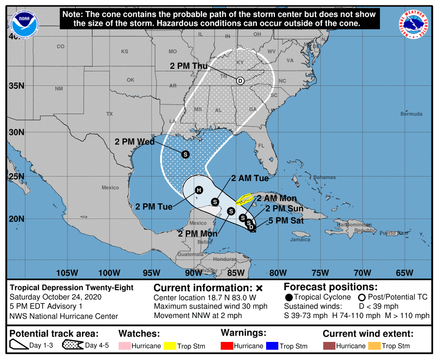
000 WTNT43 KNHC 242059 TCDAT3 Tropical Depression Twenty-Eight Discussion Number 1 NWS National Hurricane Center Miami FL AL282020 500 PM EDT Sat Oct 24 2020 Satellite imagery and NOAA Hurricane Hunter aircraft data indicate that the broad area of low pressure that NHC has been following for the past couple of days has consolidated enough to be considered a tropical depression. GOES-16 1-minute data shows the center pretty clearly, with a new area of convection close by, and a minimum pressure of 1005 mb was reported by the aircraft in that area. The surface winds were generally fairly light within about a degree of the center, but data from the plane supports a 25-kt initial intensity. The tropical depression hasn't been moving much, but recently it has started at least drifting toward the north-northwest. A shortwave trough moving across the southeastern United States should keep the cyclone in a rather weak steering pattern during the next day or so, with only a northwest drift anticipated. Mid-level ridging should build over the northern Gulf of Mexico on Monday, forcing the depression to move faster to the west-northwest toward the Yucatan Peninsula or Channel. The ridge shouldn't last too long, however, with a substantial upper-level low forecast to eject out of the southwestern United States in a few days, causing the tropical cyclone to sharply turn to the north and northeast on Wednesday. The guidance isn't in very good agreement, and these types of trough ejection scenarios can have significant timing differences. At this time, the NHC track forecast leans a little more on the global models than the regional hurricane models, and is just west of the model consensus. While the large-scale shear is fairly light at the moment, the low- and mid-level circulations of the depression are not well-aligned. Thus, it might take some time for the system to strengthen despite low shear and very warm waters. In a day or two, the depression will likely have a structure that supports a faster rate of strengthening, and the intensification rate is increased while the cyclone is near the Yucatan. Although the forecast shows the system reaching hurricane strength in the southern Gulf of Mexico, this is rather uncertain given the potential land interaction and only a narrow area of favorable upper-level winds. A combination of cooler shelf waters and increasing shear will likely weaken the cyclone below hurricane strength as it approaches the northern Gulf Coast. However, strong tropical storms can still produce significant storm surge, rainfall, and wind impacts, and residents in this region will yet again need to monitor another tropical cyclone moving northward across the Gulf. KEY MESSAGES: 1. The depression is forecast to strengthen to a tropical storm Sunday and could bring tropical storm conditions to extreme western Cuba on Monday, where a Tropical Storm Watch is in effect. There is also a risk of tropical storm conditions in the northern Yucatan Peninsula of Mexico Monday night and Tuesday. 2. Through Wednesday, heavy rainfall is expected across portions of central and western Cuba, the Cayman Islands, Jamaica, the northeast Yucatan peninsula of Mexico, southern Florida and the Keys. This rainfall may lead to flash flooding in urban areas. 3. The system is forecast to approach the northern Gulf Coast as a tropical storm on Wednesday, and could bring storm surge, rainfall, and wind impacts to areas from Louisiana to the Florida Panhandle. Residents in these areas should monitor the progress of the depression and updates to the forecast. FORECAST POSITIONS AND MAX WINDS INIT 24/2100Z 18.7N 83.0W 25 KT 30 MPH 12H 25/0600Z 19.0N 83.2W 30 KT 35 MPH 24H 25/1800Z 19.5N 83.5W 35 KT 40 MPH 36H 26/0600Z 20.1N 84.2W 40 KT 45 MPH 48H 26/1800Z 20.9N 85.6W 45 KT 50 MPH 60H 27/0600Z 22.0N 87.5W 55 KT 65 MPH 72H 27/1800Z 23.4N 89.4W 65 KT 75 MPH 96H 28/1800Z 27.5N 91.0W 55 KT 65 MPH 120H 29/1800Z 35.5N 84.5W 25 KT 30 MPH...POST-TROP/EXTRATROP $$ Forecaster Blake
-
Might become a quality system that devolves into a junk landfall.
-
5PM ADT is interesting... Vertical wind shear is expected to remain low over the next two days and intensity changes will likely be influenced by inner core fluctuations. The intensity guidance does suggest some modest intensification is possible in the short-term as Epsilon moves over a warm eddy in the Gulf Stream, assuming the current secondary eyewall consolidates. Based on this reasoning, the official intensity forecast was nudged slightly upward for the first 24 h. Afterwards, slow weakening is expected but Epsilons 34- and 50-kt wind field should continue to expand to the south while it undergoes extratropical transition, completing the process by early Monday. There was a recon flight mission to deploy an OHC bouy drop NE of Bermuda. It's possible they found the Gulf Stream OHC to be warmer and deeper than expected. Especially if a warm eddy in in the forecast track. Would be fascinating to see Epsilon's larger eye band actually intensify at such a high latitude so late in the year but outflow is bonkers and shear will remain low enough to not be a deterrence. Guess we'll see...
-
Latest ASCAT shows an area of suspicious convergence that might be trying to close off low-level vorticity near Grand Cayman. See if convection can persist there through this evening.
-
May have some fireworks in the Caribbean in early November. That's a lot of supportive 200 hPa divergence and lift incoming thanks to a very convectively supportive MJ phase. We may have a strong close to the season.
-
Going to go ahead and fire up a thread for this. Conditions look favorable and progs are up TCG will occur with this disturbance over the next 24-48 hrs. Close proximity to land and potential for a hurricane lingers. How fast TCG occurs and how quickly a core can develop will have a lot to say for downstream impacts. Based on the synoptic setup, this could be a EGOM / Florida Peninsula threat down the road. Obviously a threat to Cuba and the Caymans in the shorter term for significant flooding.
-
Definitely getting interesting. Small surface trough under a ridge. We'll see if strong convection can close off something at the surface. Atmospheric conditions are favorable. Very moist airmass. Good convergence at the surface.
-
Very nice presentation. Large outer band. Perhaps even some frontal characteristics in the outer fringes due to the large-scale trough / upper low, with of course the purely tropical Epsilon still powering on in the center.
-
The Atlantic Basin has crossed 130 ACE for the season. http://tropical.atmos.colostate.edu/Realtime/index.php?loc=northatlantic What is clearly phenomenal isn't necessarily the ACE the Atlantic has produced, which is below what I had expected, but the deadness of the WPAC.
-
Newest MW..
-
-
Don't throw in the towel just yet. Lingering boundaries into the Caribbean could still lead to a strong hurricane even in November. Though I don't expect the Atlantic to produce a Cat 5, we could certainly see another major, even a landfalling one before the door is slammed shut on 2020.
-
Pretty amazing little hurricane. A shallow tropopause with cold pool aloft under minimal shear. Core of hurricane positioned perfectly under the small anticyclone, which is of course positioned perfectly in the middle of a large-scale upper trough. Marginal 26-27°C SSTs is more than enough to drive significant lapse rates and core convection. I still didn't expect a major. But I'm not surprised. Ophelia did as much even with cooler heat content but had an even shallower tropopause / cooler dam aloft. Just gotta have the right atmospheric setup at higher latitudes late in the season. That being said, Epsilon has probably peaked. Arguably the prettiest hurricane of the season.
-
Epsilon is going to outpace its intensity forecast in short order. Nice CBs occurring around the core with plenty of lightning. Think this is a hurricane this evening and a Cat 2 seems likely now.
