

Carvers Gap
-
Posts
17,461 -
Joined
-
Last visited
Content Type
Profiles
Blogs
Forums
American Weather
Media Demo
Store
Gallery
Everything posted by Carvers Gap
-
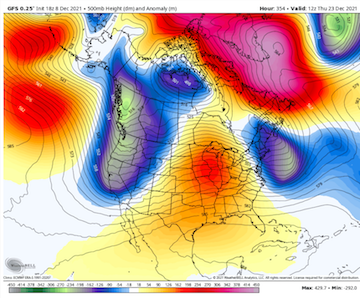
12z GFS basically splits the SPV and likely a part of the TPV right around Dec19th. Part of it heads south into the Lower 48. Very likely anything after that is in-correct, but a wild, wild run.
-
Meanwhile the 12z GFS is pretty much bringing it this run. What a block.
-
Two words...NE TN. Location matters. A lot of folks outside of TRI won't think about 14-15, even on the Plateau. I probably had almost 30" of snow here in January and February alone - and that is in Kingsport which is less snowy than the other TRI. We score a bit differently than the rest of the forum area. SE KY and SW VA folks can relate to the differences of the micro climates. Kingsport does not do well with NW flow events(Bristol and JC do well), but does very well with events along the Atlantic provide we can get under a deformation band west of the Apps. Usually when it is colder in western areas of the forum, it is often warmer here. Last winter was an extreme example. Memphis got hammered for days. We saw very little.
-
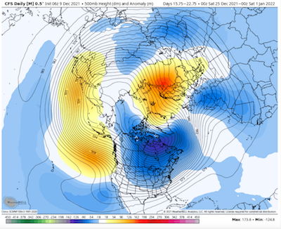
The 6z CFSv2 still holding onto a colder week after Christmas and maybe also the first week of January before likely reverting back to a western trough by the second week of January.
-
Man, you know I am old when I lived through an ancient analog. LOL. Oddly that winter was a weird deal where the polar vortex was trapped and when several deltas further south than was normal. Can you imagine the, "Polar vortex! Polar vortex!" talk if we had had social media back then. The PV(or at least a piece of the PV) sagged into E TN. Not sure I would say extinct, but would agree that is a rare, rare occurrence - even for then. 2017-18 is probably more reasonable in today's climate, and the rivers froze every bit as solid here as they did then. The 84-85 winter was not overly cold for most of that winter - was super warm immediately following and not a soul complained about those warm temps either. It was those crazy departures during those couple of weeks January that made it a cold winter. Northwest flow events were spectacular during that time frame. Man, we went to a crap ton of Saturday school to make up for those weeks. What is crazy is that many of the winters of the 80s were much warmer than the 70s, and progressively so. Having grown up as a grade schooler during the 70s in Knoxville, I am forever jaded to what "normal" winter should be like. It snowed often. By the late 80s, winters at TRI had flipped quite warm. Anyone want to take a guess at what also flipped then? The much talked about AMO. I think when the AMO flips back, those cold and snow intrusions will likely occur again but w/ 21st century climo style. The snowy benchmark winters of my lifetime (that stand out to me): 84-85 14-15 95-96 (lived in Knoxville at the time...TRI folks would rank this year second) A couple of years after 1975 92-93(blizzard) 93-94 09-10 So every decade has memorable snow and cold for me except for the one we just entered....Two events that I doubt that I ever see again in my lifetime are the Blizzard of '93 and the cold of January 84-85. So while we are reminiscing about the days of old. You all know that I like the thunder in the mountains rule of thumb, right? BTW it worked again this week. Here is another....I have heard this old tale told many times. Old timers talk about trees exploding when it gets cold as well. Now, personally I think that is more likely that a tree falls during extreme cold and gets busted up pretty good. However, I had a biology teacher who spoke that like the truth in high school.
-
Here is the link to the CPC analogs. It will change each day.
-
Just tagging on to what John is saying. Agree with John in saying this is not a forecast, but the CPC has '84 placed in both the 6-10 and 8-14 twice each. CFS has a similar outcome, before warming back up. Again, not saying that will happen as that is THE benchmark winter for extreme cold in NE TN, but we can still look at similarities. There are some warm winter analogs in that CPC analog package as well. Almost seems as if we are heading for one extreme or the other or both. Personally, I think it is going to be tough to beat down that SER for any length of time. However, it would not surprise me to some extreme swings as that SER wave is beaten down(before bouncing back). There is wicked cold waiting in the wings in Canada. When the SER relaxes, the push of Arctic air would likely make it through almost all of the forum area and hold for a few days. Check out the end of the 6z GFS run both at the surface(temps) and at 500 in the LR. Very similar to the CFS. The CFS has been bouncing around between ridge and trough for eastern NA. I suspect the GFS is in a hurry, but the CMC was pretty close in its run. For now the GFS is on its own, but cold late in the run. It is going to need some support before I give it any weight. If it was January, I would take the Euro and run(still might). But I trust the Euro only slightly more than the GFS until the winter pattern settles in. Then, the Euro is the "go to" for me. Really nothing new today from my perspective. Lots of very cold and very warm temps on the map. If forced to make a call, I would say that bitterly col air will almost certainly plunges into the western Prairies of the Dakotas, Canada, and Montana. The wildcard is whether it can find its way eastward. I think there are two windows to watch - one around Christmas and the other during the first week of January. Neither is a certainty, but I suspect we see 1-2 trough amplifications in the East where the cold rushes eastward behind a cutter. Our way to score some snow at that point would be to have something develop on the trailing edge or to have something phase on the Arctic front. Then, after the cold surges east the stand wave SER quickly pushes back. Just a guess, but that is my thinking. Again, lots of extreme temps(warm and cold) on that map. Severe wx might be a concern also with the mixture of those two air masses a near certainty somewhere over the Lower 48. Sorry, long post which didn't say a whole lot. Huge grains of salt as the pattern is likely base warm with cold intrusions. Just trying to find windows for winter wx.
-
Personally I suspect the GFS is slightly too quick in breaking down that big ridge as it is formidable. I like the 18z CFSv2 this evening. Reasonable look and makes sense. That said, if an NAO is developing it is going to be tough to model at this range. IMHO, getting the NAO right is still a tough feature for computer models to get right at LR.
-
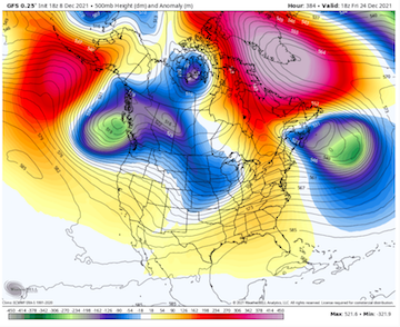
Just because we are in a boring pattern at the moment. Normally, I would never post a map this far out, but it is at least worth some fun. And if we can't have fun, what in the world are we doing here, right? This is truly a fantasy land -NAO. Perfectly positioned.
-
And out of colors on the 500mb map as well for the NAO. That would be an extreme run. Huge grains of salt. We all know the drill. Fun though.
-
@Holston_River_Rambler, the 10mb anomaly at that timeframe is off the charts. LOL. Literally out of colors on WxBell.
-
FTR, the surface is cold in that shot. Not sure it could be anything but cold. Might be the biggest NAO I have ever seen on modeling. If anything, goodbye strat!!!!
-
Probably should be in banter since it is so far out there, but wow.
-
The 18z GFS has found the -NAO again after d10. It is pronounced.
-
The invest is a thorn for sure!
-
I like the pro tips. Let’s keep those coming! LOL. Hate to hear about the ski trip. Dr No visited the UT three point line last night in NYC. Have never seen anything like it.
-
I think if I was in Alaska right now, I would be making sure I had things ultra winterized - more so than normal for there.
-
If you want a redux of last year's sever Arctic outbreak in the nation's midsection, that is it. -61F air(not departures, but 2m surface temps) are in NA for that run of the GFS. Basically, the cold in northern Russia rotates over the pole and is in a southerly trajectory over NA late in the run. Impressive.
-
Welp, looks like we have some folks on the board. I could see it on Bays and maybe could hear some rain with ice hitting the leaves, but no official logging of snow IMBY. Awesome for the other folks though!!! 12z GFS, as one very much expects, has another variation of a blocky pattern developing after the 21st. It actually manages to get one trough through around the 22. What is waiting in the wings on that run is very cold. The 12z GFS gets there differently, but manages a double block. This time the -NAO is forced by the AN heights exiting the mid-latitudes of eastern NA. It is less of retrogression of AN heights in northern Europe. That would imply the 12z feature would be transient. Retrograding NAOs tend to hold much longer than ones which are forced IMO. Oddly, the Pacific is in our favor after 300 on that run. Sur seems like an EPO ridge is going to hold once those AN heights in the GOA slide eastward. I guess the main message for that run(and the 6z and 18z run) is that the delivery system for a very cold air mass into the Lower 48 is showing up in the LR of the GFS operational. LONG way to go, but the big red blobs are less stationary and semi-in-the-right place late in that run. Edit: After 360 the trough dumps west bu the Alaskan block and NAO blocks are strongly in place. We take that. The trough would very likely kick eastward if those features are real. Truly, what we want in place is the block, and then let the chips fall.
-
The 6z GFS has pretty substantial blocking beginning to form around the 19th. You can see what it does from there. 0z was less impressive, but it is back(for now) on this run. At this range, doubt the look will be consistent, but at least want to see it showing up some.
-
Didn't mean it like that at all. I just needed to go back and read it. Had no problem at all with any wording. You always do a great job! My apologies if it sounded that way.
-
I need to go back and read your post again! Lots of similarities to last winter for sure, but just a bit earlier. Second year La Nina might push that just a hair eastward - anyway I am hoping so. LOL. And I know you know this, but BN temps in early January are COLD! We'll see. I may be out mowing the grass at this rate.
-
The GFS ooks like the 12z CFSv2 w/ a double block late in the run. Monster EPO ridge while the ridge over the eastern US retrogrades into southwest. Ridge to the east of Greenland. That would unlock the floodgates(meaning cold air masses) if real.
-
For kicks and giggles check out the Alaska AN heights late in the 18z run. You know we are sitting on a potentially long stretch of warm wx when we are looking that far out. Impressive nonetheless. That would deliver a big shot if cold.
-
Hard to tell. I think there is really a chance for cold after the 20th, and especially after the New Year. But that is preliminary guesswork at this point. For now, I am watching the operational GFS at LR as it will likely catch(even be a bit too quick) cold intrusions more quickly. The ensembles will change very slowly. I think the pattern itself is base warm. The trick is trying to nail down anomalously cold air masses embedded within a warm pattern. That is no easy feat. I don't think we will see wall-to-wall cold like the CFSv2, but it is not without precedent. Also, the warmth is not without precedent either. As you know -NAOs are notoriously tough to predict at range. Last year's -NAO does give me hope that we may be entering a cycle where it is more prevalent during winter, but we will see. Global ensembles go out to the 23rd, and they are solidly in the status quo camp. I really think operationals will see any amplification or reorientation of ridge/trough axis alignment...first. For now, we wait.


