-
Posts
17,420 -
Joined
-
Last visited
Content Type
Profiles
Blogs
Forums
American Weather
Media Demo
Store
Gallery
Everything posted by Carvers Gap
-
@Holston_River_Rambler, I may do a post in the historical winter thread on 17-18. You are more than welcome to chime in. The swings that winter were WILD!!!! We had a stretch of about seven days that were roughly -20F below normal....and then then hit 82 in February...got an SSW....and then there was light, but measurable snow at TRI twice during April. That is classic La Nina. Easily one of the most frustrating winters in terms of snow, but watching the GFS nail the strat warm from 16 days out was something to behold.
-
There is a wicked cold snap earlier in the 17-18 winter which is hidden because it straddled two months. End of December and beginning of January saw the N Fork freeze pretty much solid here. We had nearly a week where we didn't get above freezing. Don't think it snowed at all as the PNA/EPO was almost to the Arctic(or more). Was very frustrating to have that much cold and very little snow. Classic La Nina cold outbreak. Spring 2018 was crazy. I need to go look at that thread again. I may have been in JC picking up a water heater during April with snow showers coming down.
-
LOL. Man, I am afraid to go look at those threads - I was living large that year! As you know, Kingsport normally gets hosed when it comes to snowfall in the TRI. @Holston_River_Rambler, the EB? LOL. Seriously, our elevation is lower due to being right on the river. My house sits about 100-150' higher than the river plain, and I prob get 25% more snowfall than downtown. Then again, I am upwind of the heat dome.
-
We bough a 4WD after that winter as a family vehicle and haven't had to use it since!!!! LOL. Our van was useless for two months in 14-15.
-
I generally like the Australian. Nah, LOL. It is the coldest which is why I say that. I talk about the MJO, but I truly hate to look at it on modeling - meaning going to the MJO region and looking at charts for convection. @nrgjeff, which model is it the handles the western Pac and IO better? I would guess Euro but not sure that is a slam dunk answer.
-
So the Euro Weeklies are wonky again. Literally, the mean ensemble repeats the exact same look through the end of January with almost the exact same details repeating week after week. That has always been a red flag to me, because that isn't real life. It doesn't go below normal at any point. Here is the wonky part. The control goes below normal during the last week of December and stays BN for the entire run! The entire run.... On a sad note, the last two runs of the CFSv2 have left the cold camp. It will probably be back. That is why I don't share a foxhole with that model. It is a waffler. LOL. But I like it on cold runs. The GFS operational and Euro control are the keep in the castle of cold. Those are our holdouts. Stay strong, 0s and 1s.
-
That is insane!!!!
-
Yep, that is what we have been saying on this forum for several days. Debatable about the coldest air being over here. Yesterday, that was the general trend. Today, though very cold in NA, the coldest remained in Siberia for most of the models I could find. Nothing set in stone at all. I look for one of two mechanisms to drive it both, -EPO or -NAO or a cutter which wraps cold air in behind it. I am probably missing something. Teleconnections looked good this AM after d12 or so. I think we are likely looking at an amplification which doesn't hold. However, if we can get 4-7 days of good, cold Arctic air...we have a shot.
-
Modeling has been awful this fall at catching trough amplifications. Ensembles will likely miss the troughs embedded in this pattern at range. I don’t use them as a primary source in order amplification as they smooth it out at range. Ensembles will be last on board. What I am looking for is not a flip to long term cold which I think is unlikely thought not implausible. So, same plan as last year. Trying to find cold shots within the pattern. As PSU noted in a great post yesterday in the MA forum, we live in an area where snow is the anomaly. It is easy just to say it is doing to be warm and not snow. The “not snowing part” is true for 95% of the days of winter or more. So, it is house money to go warm-up and rain. That is the norm. Tough part is being able to spot a trough amplification before ensembles do. So, I don’t see myself as a hobby forecaster, but someone who is hunting winter wx.
-
Add the 12z Canadian to the mix as it is now picking up significant AN heights over Greenland. So that is the GDPS and the GFS which are now picking up blocking which forms around d8. Again, a lot of this is speculation until we can get it inside of d7 where skill will increase with each day at that point. The NAO is NOT a given and is notorious for head fakes, but to have it on two models with cold air already in place over NA...this raises the chances for an eastern trough amplification after the 19th. I am not saying this is a pattern change as I am not sure what pattern we are changing at this point. We have noted many times that mega ridge in the East during winter are often precursors to strat warming and cold air getting into the Lower 48.
-
12z GFS basically splits the SPV and likely a part of the TPV right around Dec19th. Part of it heads south into the Lower 48. Very likely anything after that is in-correct, but a wild, wild run.
-
Meanwhile the 12z GFS is pretty much bringing it this run. What a block.
-
Two words...NE TN. Location matters. A lot of folks outside of TRI won't think about 14-15, even on the Plateau. I probably had almost 30" of snow here in January and February alone - and that is in Kingsport which is less snowy than the other TRI. We score a bit differently than the rest of the forum area. SE KY and SW VA folks can relate to the differences of the micro climates. Kingsport does not do well with NW flow events(Bristol and JC do well), but does very well with events along the Atlantic provide we can get under a deformation band west of the Apps. Usually when it is colder in western areas of the forum, it is often warmer here. Last winter was an extreme example. Memphis got hammered for days. We saw very little.
-
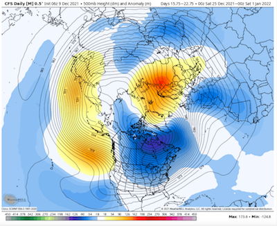
The 6z CFSv2 still holding onto a colder week after Christmas and maybe also the first week of January before likely reverting back to a western trough by the second week of January.
-
Man, you know I am old when I lived through an ancient analog. LOL. Oddly that winter was a weird deal where the polar vortex was trapped and when several deltas further south than was normal. Can you imagine the, "Polar vortex! Polar vortex!" talk if we had had social media back then. The PV(or at least a piece of the PV) sagged into E TN. Not sure I would say extinct, but would agree that is a rare, rare occurrence - even for then. 2017-18 is probably more reasonable in today's climate, and the rivers froze every bit as solid here as they did then. The 84-85 winter was not overly cold for most of that winter - was super warm immediately following and not a soul complained about those warm temps either. It was those crazy departures during those couple of weeks January that made it a cold winter. Northwest flow events were spectacular during that time frame. Man, we went to a crap ton of Saturday school to make up for those weeks. What is crazy is that many of the winters of the 80s were much warmer than the 70s, and progressively so. Having grown up as a grade schooler during the 70s in Knoxville, I am forever jaded to what "normal" winter should be like. It snowed often. By the late 80s, winters at TRI had flipped quite warm. Anyone want to take a guess at what also flipped then? The much talked about AMO. I think when the AMO flips back, those cold and snow intrusions will likely occur again but w/ 21st century climo style. The snowy benchmark winters of my lifetime (that stand out to me): 84-85 14-15 95-96 (lived in Knoxville at the time...TRI folks would rank this year second) A couple of years after 1975 92-93(blizzard) 93-94 09-10 So every decade has memorable snow and cold for me except for the one we just entered....Two events that I doubt that I ever see again in my lifetime are the Blizzard of '93 and the cold of January 84-85. So while we are reminiscing about the days of old. You all know that I like the thunder in the mountains rule of thumb, right? BTW it worked again this week. Here is another....I have heard this old tale told many times. Old timers talk about trees exploding when it gets cold as well. Now, personally I think that is more likely that a tree falls during extreme cold and gets busted up pretty good. However, I had a biology teacher who spoke that like the truth in high school.
-
Here is the link to the CPC analogs. It will change each day.
-
Just tagging on to what John is saying. Agree with John in saying this is not a forecast, but the CPC has '84 placed in both the 6-10 and 8-14 twice each. CFS has a similar outcome, before warming back up. Again, not saying that will happen as that is THE benchmark winter for extreme cold in NE TN, but we can still look at similarities. There are some warm winter analogs in that CPC analog package as well. Almost seems as if we are heading for one extreme or the other or both. Personally, I think it is going to be tough to beat down that SER for any length of time. However, it would not surprise me to some extreme swings as that SER wave is beaten down(before bouncing back). There is wicked cold waiting in the wings in Canada. When the SER relaxes, the push of Arctic air would likely make it through almost all of the forum area and hold for a few days. Check out the end of the 6z GFS run both at the surface(temps) and at 500 in the LR. Very similar to the CFS. The CFS has been bouncing around between ridge and trough for eastern NA. I suspect the GFS is in a hurry, but the CMC was pretty close in its run. For now the GFS is on its own, but cold late in the run. It is going to need some support before I give it any weight. If it was January, I would take the Euro and run(still might). But I trust the Euro only slightly more than the GFS until the winter pattern settles in. Then, the Euro is the "go to" for me. Really nothing new today from my perspective. Lots of very cold and very warm temps on the map. If forced to make a call, I would say that bitterly col air will almost certainly plunges into the western Prairies of the Dakotas, Canada, and Montana. The wildcard is whether it can find its way eastward. I think there are two windows to watch - one around Christmas and the other during the first week of January. Neither is a certainty, but I suspect we see 1-2 trough amplifications in the East where the cold rushes eastward behind a cutter. Our way to score some snow at that point would be to have something develop on the trailing edge or to have something phase on the Arctic front. Then, after the cold surges east the stand wave SER quickly pushes back. Just a guess, but that is my thinking. Again, lots of extreme temps(warm and cold) on that map. Severe wx might be a concern also with the mixture of those two air masses a near certainty somewhere over the Lower 48. Sorry, long post which didn't say a whole lot. Huge grains of salt as the pattern is likely base warm with cold intrusions. Just trying to find windows for winter wx.
-
Personally I suspect the GFS is slightly too quick in breaking down that big ridge as it is formidable. I like the 18z CFSv2 this evening. Reasonable look and makes sense. That said, if an NAO is developing it is going to be tough to model at this range. IMHO, getting the NAO right is still a tough feature for computer models to get right at LR.
-
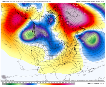
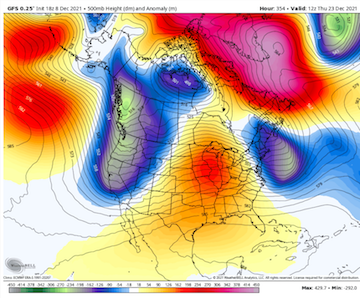
Just because we are in a boring pattern at the moment. Normally, I would never post a map this far out, but it is at least worth some fun. And if we can't have fun, what in the world are we doing here, right? This is truly a fantasy land -NAO. Perfectly positioned.
-
And out of colors on the 500mb map as well for the NAO. That would be an extreme run. Huge grains of salt. We all know the drill. Fun though.
-
@Holston_River_Rambler, the 10mb anomaly at that timeframe is off the charts. LOL. Literally out of colors on WxBell.
-
FTR, the surface is cold in that shot. Not sure it could be anything but cold. Might be the biggest NAO I have ever seen on modeling. If anything, goodbye strat!!!!
-
-
The 18z GFS has found the -NAO again after d10. It is pronounced.
-
The invest is a thorn for sure!


