

Carvers Gap
-
Posts
17,461 -
Joined
-
Last visited
Content Type
Profiles
Blogs
Forums
American Weather
Media Demo
Store
Gallery
Everything posted by Carvers Gap
-
Just because it is a slow night....will talk the 0z GFS By 189, there is a continue trend of disrupting the Aleutian high. Trough would appear to be headed eastward...we'll see if we don't get a cutter first.
-
That pattern I just posted looks remarkably similar to LR modeling today...and also to Feb 20'. One was a nada and one was a La Nina. One was a dud and the other was historic. @John1122, very interesting about LA and great post. I have always considered storms coming in at the latitude of LA a good thing. That has not held true so far. I have held to the rule of thumb that storms that enter the west at a specific latitude normal exit on the east at a similar latitude. Not always true, but wonder at some point if that works in our favor.
-
Yeah, I kind of stumbled into the Feb 20 thread. Pattern looks very nada right now...similar to that. Here is last year's pattern that ran up to the big storm.
-
Not sure how I got into the Feb 20 thread! LOL. Last year's GEFS(about two weeks prior to the winter/ice storm) do indeed look almost identical to LR maps right now. Correct link is above. Thanks to @Holston_River_Ramblerfor posting those gifs. They are a great historical tool.
-
19-20'...What was the ENSO state that year?
-
Ah, yes. Thanks. Grabbed the wrong one. Here is the set of Weeklies running up to the outbreak last February. Still, lots of similarities to now.
-
Update: This is the wrong link. Correct link to the weeklies is below. Unreal the similarities. Thought this was kind of fun. This is what the Weeklies had for the pattern that ran-up to the crippling Arctic outbreak/over-running event last year during mid-February. @Holston_River_Rambler, just needed your map - not picking on you in the least. Take a look at Holston's bleaklies thread. Indeed, they looked bleak. Two and a half weeks later, the power was out in the western areas of the forum.
-
Trough eventually lifts out, but I am starting to wonder if we might be seeing the initial seeds planted for a pattern reset. GFS is likely early, but it has hammered the Aleutian ridge during several recent runs. Not saying the reset will be any better. The LR result of that is the PV lifts northward, and we are left with zonal. Nor worried, that will very likely not be the same next run.
-
LOL. That is an awesome run. TPV gets trapped and the dam breaks.
-
Impressive, impressive run of the 18z GFS. I also didn't think the Euro Weeklies looked half bad. Its control looks strikingly similar to the current GFS.
-
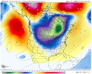
294 on the GFS is how this gets done...just an example and not the gospel. This is the second straight run with something similar.
-
The 18z GEFS is how winter gets unleashed for a time. Impressive trough.
-
Interestingly, the 18z GFS is sort of doubling down on the same deal. It is hammering the Aleutian high(edit).
-
12z GFS... Much different run. Cold has come earlier. EPO ridge is in place after the 1st and AN heights into the GOA. Good trends overall.
-
12z GFS coming in is a bit cooler around December 30th. We will see how that affects the rest of the run. Might be interesting.
-
Three straight days of BN temps at TRI. Will today be a fourth? Modeling pretty much nailed the pattern just prior to Christmas as it did the days prior to the 20th. It likely will nail the pattern after Christmas as well from the 25th to the 31st. We are now watching the pattern just after New Year's. See John's post above. Welcome to the world of extremes. Base warm pattern with interludes of cold(maybe severe cold at times). What we need, to grab a quote from another thread, is an active STJ. Dry conditions are our main nemesis, not just the longer interludes warm wx. Looks like we get another amplification of the eastern trough around Jan 3rd. That looks like a window with some potential. Modeling has been fairly adamant that we will see a trough roll through then. So, it is progressing along. What happens after that potential cold shot is open for much debate. January is one of those months that doesn't require strong BN temps for snow. Even slightly AN temps will get the job done.
-

Fall/Winter Banter - Football, Basketball, Snowball?
Carvers Gap replied to John1122's topic in Tennessee Valley
Vols with a big win over Arizona. BIG! -
Been out finishing up some Christmas shopping. Modeling still looking good.
-
And that would make some since given what we are seeing in the LR.
-
Waiting for the MJO to roll right now. We may be looking at a pattern change, but more likely a relaxation of some sorts and full change later in January. However, what is on most modeling this morning is the first hints of the current pattern beginning to break down. WxBell still has the PNA negative on its run, but that is a PNA ridge that pops on the 6z GFS. Oddly, and I thought about this yesterday, but wasn't brave enough to post it. It is like the -NAO(which normally we want very strong) is causing a buckle which locks the cold out West, because it is in conjunction with the Aleutians high. When the NAO gets out of the way, it is like a dam breaking. That said, it does its work by forcing the cold south. Without it, the cold would slide across the northern border states. Not saying that is the gospel, but it did cross my mind. Reading through the MA forum which has a great winter thread going as well, they mention the NAO is more strongly correlated to eastern cold during mid and later winter.
-
The 6z GFS is nearly a pattern reversal to an eastern trough. The Euro control was nearly the same thing. Really good trends in modeling overnight. After reading John’s post, I agree. Looks like a 6 which is now moving to a 7. Have to think the typhoon was causing havoc last week.
-
0z ICON and CMC sneak a cold front through on the 29th. Worth noting, because that is different than what we have been seeing.
-
I think we can deal with the Aleutian ridge. It is actually common during many good La Nina winters. The GFS for the past 2-3 runs has shown it basically working to connect over the top with the NAO. If that occurs the TPV will be forced south into a broad trough between the Rockies and the Apps. I take the 0z GFS as is....that would likely be an overrunning event if real. Great discussion, everyone....
-
It was not as warm here today as I thought. Maybe I have seen all of these warm maps, and just got ahead of myself. Neighbor of mine had his fireplace going all day pretty much.
- 167 replies
-
- 1
-

-
- frost
- cold front
- (and 4 more)
-
Definitely a lot of shoveling going on! LOL.
- 167 replies
-
- 1
-

-
- frost
- cold front
- (and 4 more)
