

Carvers Gap
-
Posts
17,461 -
Joined
-
Last visited
Content Type
Profiles
Blogs
Forums
American Weather
Media Demo
Store
Gallery
Everything posted by Carvers Gap
-
We will see if it is right, but the 18z GEFS is an outlier now among modeling...It may be leading the pack. Not sure.
-
Good point. This is the most recent update. What do you make of the third bulleted point in conjunction with Aleutians ridge? MJO indices continue to depict an enhanced West Pacific signal, and upper-level velocity potential anomalies show the enhanced phase crossing the central Pacific. The amplitude of the MJO has decreased, and the RMM-based MJO index depicts little eastward propagation over the past week due to interference from the La Niña base state and Rossby wave activity. The GEFS and ECMWF ensembles depict persistent enhancement over the West Pacific, with little to no eastward propagation. It is possible that this signal may reflect a temporary weakening of the La Niña atmospheric response. There is considerable uncertainty regarding the potential for this MJO event to remain coherent as it crosses the Pacific.
-
Reading reports in the SE forum of steady, frozen precip falling in western NC.
- 167 replies
-
- 2
-

-
- frost
- cold front
- (and 4 more)
-
After 300, the Alaska ridge slides southwest into the GOA. Cold air jettisoned from the Arctic headed due south. Very cold pattern beginning around 282 for most of the Lower 48. Like a dam breaking that run.
-
18z GFS again moves the Aleutian ridge....this time it builds monster heights into Canada. Looks very much like the Canadian ensemble and maybe even the Euro control. Good trend continues.
-
The 18z GFS has the cold intrusion now on Jan 2nd. We will see if that holds during future runs.
-
And the GFS at 18z is back on the cold train. That is quite a cold look around Jan 3rd.
-
I am tempted to post the temp anomaly map for the Euro control at 360...super tempted. The entire US is much below normal. Looks like the Canadian ensemble, and 12z GFS. I lean warm, but barely warm in my thinking. I wouldn't be shocked for the overall high temp in January and low temp in January to have 80 degrees between them. All it is going to take is one strong cutter into the Plains....and it is going to get super cold here.
-
I think it worthy to discuss the warm solutions for sure, but ignoring the extreme cold solutions is probably unwise. It is worth remembering that the Jan 1-5 timeframe is still in the d10-15 range. It is also worth noting that the only ensemble model with 500 heights AN after 300 is the GEFS. Who knows where this goes, but that isn't exactly a warm set of ensembles after 300. Very possible(maybe even likely) they bust, but we can't ignore colder solutions of the 12z GFS, 12z Euro control, 12z GEPS, and I also thought the EPS looked decent after 300 as well(cold centered out West by bleeding west). I tend to agree with warmer solutions right now as trends support that. I keep saying this, but this reminds me of the run-up to last year's cold/snow event in the middle and western areas of the forum. With that blocking up top and the extreme cold in Canada, I expect the wild, wild swings in modeling to continue.
-
I very much agree on all points. I just don't understand that kind of talk(cancel winter and giving up) on Dec 22nd. I mean this winter could be a dud, but very unlikely with the cold sitting in Canada right now. We literally have the Canadian ensemble, the 12z GFS, and the Euro control showing Arctic outbreaks. There are some obvious models/runs which are totally the opposite. But there is a ton of model spread right now. I suspect we see a sever Arctic outbreak this winter but I could be wrong.
-
Euro control worth a look.... Word from an old timer. Webber, Cosgrove, and HM. Roll with those guys. I don't think folks sugar coat in this sub-forum. We just generally don't get overly worked up by a warm pattern. We are from the Upper South - just as slow roll. Cold is never really "pushed back" as it was never real in the first place. We are dealing with computer models which are at the mercy of programing and quality/quantity of data input. When looking at modeling, what we are trying to find is the reality of what will come. If given 25 outcomes, what we are trying to do is to find the one which makes the most sense and will close resemble future wx. So, things aren't really being pushed back or delayed. They just weren't real to begin with. But I do understand that we don't really have a better word/phrase for it. I use the term as well. Modeling is all over the place right now. The Euro control looked very much like the 12z GFS in terms of the surface temp result over the Lower 48. It didn't get there the same way, however. In fact, the control looks an awful lot like the Canadian. I mean it drops 6-12" of snow over the eastern half of the state late in the run. The entire forum area received snow with that slp.
-
12z GEFS and 12z GEPS are worlds apart. GEFS is warmer. GEPS is colder. The 12z GEPS looks like the 12z GFS.
-
Yeah, it may be gone next run as that is a major flip which leaves me very wary. Let's see if that looks gets a bit consistent over time....or not. Doubt we see that extreme each run...and that is extreme. But we can hope that is a hint that there is some restructuring about to occur up top. I haven't looked at the strat on that run, but guessing it is on fire.
-
Updated with better graphic....Here you go...12z compared to 6z...d10.5-15.5. This is 5d mean. The actual final outcome late in the run is far more impressive than this. I like using a 5d mean in order to show this isn't just a one or two day change. This was a wholesale change which means it is an outlier until it gets support. The Aleutian Ridge leaves and the cold heads SE. That is how you draw up an Arctic outbreak. Again, NOT SAYING this is going to happen, but it is always wise to pay attention when a model switches up like that.
-
That is a large scale shift after 240 - massive. That is what HLB can do in response to an uncooperative MJO.
-
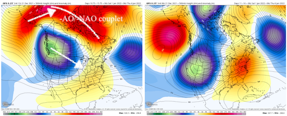
Actually that couplet begins around the 280 mark. The destruction of the Aleutian Ridge begins about 240. This not just an evolution which begins past 300. Basically, the -NAO region retrogrades. The Pac Ridge connects, gets pulled eastward, and that is how you switch a pattern. NOT saying that is going to happen, but it is a potential. We all need to be rooting for that trend to continue!!!!
-
That would be a -AO/-NAO couplet on the 12z GFS. Doubt that is right, but there it is beginning around 300.
-
IF the ensembles are correct, we should begin to see the operationals spit out some runs that look similar. The 12z GFS is a massive break from its earlier runs...adios Aleutians Ridge. Massive block up top. Trough should come eastward.
-
Doesn't look uncommon at all for weak La Ninas to stall. Good nugget right there. 98-99 was one of those late 90s winters which I don't remember fondly. I remember the grass never really turning brown during one of those - think it was that one. The West was coming off several bad years of drought. Thing to remember there is that we had several really strong El Nino's and a flipped AMO which didn't allow for a lot of variation other than warmth. Cool post. In the age of social media, a 30 day stall would be fun...only to see it snap back cold after everyone had given up. If the weather has taught us anything it Is to expect the unexpected.
-
The time frame just after Christmas has generally been warm on modeling for several runs. No surprise there. The time frame prior to Christmas it was modeled cooler than it will actually be, and that will be a bust. Less warm for sure, but just one BN day here at TRI. All three ensembles have a similar look in the 500 pattern in the same time frame as yesterday. GEFS is probably 24 hours slower. The 0z GEFS looked not great. The 6z returned to form. The MJO is definitely hitting a wall. Whether it stays there, no idea. Again, LR modeling has done really well for several weeks now in picking up the long wave pattern. Ensembles look good this morning. The 6z GEFS looks about as good as one can draw it up. We will see today how modeling reacts to the MJO staying in 7 longer. One note, if I am remembering correctly, the EPS/Euro was adamant that the MJO would loop back into 6. It didn't. However, the Euro/EPS has been correct about the warmer temps. So, taking a blend of the MJO between the GEFS and EPS is prob not a bad idea. I think this winter is just repeating a lot of what occurred last winter without the late December cold snap. I strongly suspect that the cold finds its way eastward at some point. 98-99 certainly lurks as a dud analog, but there are many which support a colder push eastward in a quick reversal of previous weeks' warmth. We should all be thankful the MJO isn't stuck in 3-4-5-6. We often talk about climatology. January is often our coldest month of the year(not speaking of norms but actual temps). I suspect it will live up to that again this year. North of I-40 we can get by with temps slightly AN. I am not convinced the MJO takes the full circuit 8-1-2. However, as La Nina wanes later this winter, it might. More likely it would loop back through the COD into warmer phases during mid-Jan. Late Jan and Feb could see a full circuit. I think the counter balance will be the NAO region. The SER will fight, but the storm track should get suppressed once it is fully established, and that should allow periods of cold to push eastward. BTW, I don't think the potential cold snap in early January is a pattern change. Looks like the pattern will be...cold builds in the West and then pushes eastward. I wouldn't be surprised to see the cold linger in the east at some point per November's pattern. Just don't see that yet...though the GEFS at 6z is close. The Canadian is outstanding...just not sure I buy that at this point. Again, MBY doesn't really see snow prior to Jan. Past decade has really had more snow prior to January than at any point I can remember. IMBY, winter is Jan-mid March. Way too early for me to worry. Long post which didn't say a lot, but there ya go.
-
Yeah, the setup on ensembles mildly worries me, especially western areas of the forum. I also feel like there is a loose connection to big wintertime tornado outbreaks and winter storms following -2-3 weeks later in our regions.
-
I don't see a delay at this point, but it certainly could happen. Looks like the Jan 2/3 timeframe has been moving forward nicely during the past several days. But we have definitely seen cold shots pushed back this winter and during past winters. Just part of it. Several days ago, this wasn't even on ensembles and now it is. I always kind of feel like getting a pattern inside of d10 is key - almost there. Indeed, the features which will induce blocking are due to begin forming within 2-3 days. If cold "delays" on modeling, it will often hang up between d10-12 as it comes into focus. In other words, when that happens it wasn't real in the first place. The real fun, Mr. Kevin, is tracking a great storm for 10-12 days and have it only turn into a frontal boundary with some backside snow. Time will tell. I certainly understand the concern though!!!!
-
The 18z GEFS is very close to nice winter pattern. Verbatim it is.
-
Yeah, the 18z GEFS is stout in NAO land.
-
LOL. What is that we say in the SEC, "It just means more."


