

Carvers Gap
-
Posts
17,461 -
Joined
-
Last visited
Content Type
Profiles
Blogs
Forums
American Weather
Media Demo
Store
Gallery
Everything posted by Carvers Gap
-
7 is tricky for January. I hear it is slightly different for La Nina. The CPC map is cold for 7 when the three month time frame is centered during December, but gets warmer for January. Again, Nina may well be slightly different. Major reshuffle in modeling. No idea where this ends-up. So, 12z flipped warm and 18z flipped crazy wild with a huge EPO ridge. Pattern shake-up likely under way...again, no idea where this heads but it could get wild. Have a good one. If you get a good tweet, feel free to share. Not much to talk about at present as we get ready to ride out a warm-spell after Christmas.
-
The 18z is the ying to the 12z's yang. If you watch the global wind pattern at 200-300mb, you can see each deepening of the western trough is progressively eastward. Why is that important if true? That means the pattern is progressing eastward. The 18z features a monster GOA positive height anomaly late in the run. No idea where this is headed, but models are all over the place. Likely culprits are a strat warm(no necessarily a split) and also bitterly cold air over the western Canada(likely a feedback problem). Been a wild day of model watching!!!!
-
When you see a ridge over the mid-latitudes(especially over eastern NA) hook-up with a -NAO....we have seen this for several years, and it nearly always precedes major changes in stratospheric anomalies. The consequence of that coupling is model mayhem and extreme cold dropping into either EurAsia or NA. That is all I have on that. Let's see if that trend continues.
-
I strongly suspect we are about to see some MAJOR happenings in the stratosphere if that run is even 25% correct. I should have caught that at 12z when the models made an about face. We have seen great patterns during prior years just go poof...usually the strat is getting HOT!
-
Wild run by the 18z GFS underway just in terms of how cold it is to the previous run. Again, it doesn't hurt to repeat that the ultra cold air in this pattern is playing havoc in concert with two very strong anomalous blocking regimes. Could be a wild next month of weather in terms of extremes in both North America and our forum area.
-
That was what was said last winter....always safer to go warm. Last winter saw historic cold and snow in western parts of the forum area. I think we will be ok.
-
If looking for positives, the end of the 12z EPS run looks plausible. I still like the Dec 20-30 as a transition time frame, especially at high latitudes. Jan 1-10 looks cold-ish though I am less confident after the 12z suite. Warm-up third week of Jan, and then maybe we see true winter later in January. Again, similar to last winter for those just to my west. Almost looks like the EPS didn't flip warm as much as it delayed the cold by 48 hours. I can hear the eye roll and understandably so as I share the same concern - cold pushed back again and I agree. But, not uncommon for that to occur. I like the timeframe around New Year's for a transition to seasonal cold with some warm interludes for sure. As Jeff notes, the SER is going to fight all winter. I also agree that the NAO at some point will hook into the wester Pac ridge. I think that is when we score a decent pattern. The EPS has this late.
-
Looks like the GEFS/GEPS are accentuating the western Pac ridge. Almost looks like a feedback error. My guess is that modeling is not even close to having a solution for the first ten days of January. Not good trends at 12z but a ways to go. Seems like whichever area of blocking is accentuated(even in the slightest), it is moving the trough around by thousands and thousands of miles. On the plus side, the CFSv2 is much colder this run. I just think things are going be all over the place. Reminds me A LOT of last winter.
-
Same trends on the 12z EPS so far. Might be time to tune-up the lawnmower!
-
I hear ya. This pattern is an extreme pattern. Just tough to know if we have the bear or if the bear has us! I think we see some cold and snow...maybe a lot of it at times. Warm Decembers usually lead to one of two outcomes - non-winters or big winters. Looks like this is going to be a year when Canada is really cold. I think we see maybe 1-2 severe surges of cold. I suspect the MJO got wonky on the GFS at 6z. CPC's MJO stuff is not available for some models(don't know if those are connected or just a tech issue for them). Saw where Robert had a new post on WxSouth. Anyone have access to it? Not looking for a repost, but just if he thought it might get cold. It won't take but a small adjustment for it to get really cold here. Oddly, I don't want to be in the bullseye for cold right now.
-
Boy, we had better hope the 6z and now 12z GEFS are not right. 12z GFS never went BN for the entire run. 12z GDPS looks great. I don't think the American suite is handling the block well. Crazy how the model sees it first, and then tries to break it down so quickly. Once the block retrogrades into the Davis Straits and the model gets inside of d12....should see some more cooling in the model. Though admittedly, this feels almost exactly like last winter without the Christmas cold snap. But as Cosgrove mentions, at some point this pattern could send brutally cold air southward.
-
Bring on the rain in NE TN, it is badly needed. La Nina is doing the work here in terms of low rainfall. I think remember that the Ohio Valley can get a lot of rain during La Ninas. That might be helping middle TN. Rain yesterday helped, but our urban streams are still quite low (as of last night). Not even a trickle was going over the dam at Bays last week.
-
That is wild. With November being so cold, would have thought they would have recorded at least a trace. Higher elevations here have recorded some.
-
Not a lot of changes overnight. There is one trend which I don't like which is seeing the MJO loop into 8 and back into 7. The GEFS switched from being very cold at 0z to quite warm at 6z. Might be a blip and might not. Looks like American modeling, CFSv2 included, has had something change between 0z and 6z. Now, that is no uncommon but worth noting. GEPS and EPS look very good. However, I am wary of any blip on the GEFS in particular as it can grab a trend first. I do think the NAO does its work. Addendum: The GEFS at 6z weakens the -NAO more quickly. This is a bias in American modeling which is to break down high latitude blocking too quickly. I don't discount it though quite yet. Let's see what other modeling does.
-
JB mentioned this evening that some of the air being modeled is so cold that it is giving models fits. Remember last year how the models had the EC at record cold temps for a while, but it switched to the nation's mid-section. Models will be all over the place with very cold air. Key right now are the delivery systems are in place for Arctic air. Looks like cold will setup shop out West and push East. Classic, classic La Nina look. But everyone should have a health distrust of modeling at this range. Huge grains, right!!!
-
Another nice set of ensembles at 12z.
-
As Holston mentions, the 500 pattern after d10 has the NAO retrograde west and slightly south. Trend overnight(and yesterday) is for some modeling to connect that NAO to the Pac ridge. What we are seeing, and it is out here so huge grains, is a pattern which could potentially go BN right during the coldest weeks of winter. It is not impossible that a piece of the PV could get dislodged under that type of block and get sent into the Lower 48.
-
And the 0z. ICON looks similar, but is probably too quick with the transition....but that is a whopper of a NA trough at 500. 0z is less enthused, but if extrapolated....likely would have gotten there.
-
That is the first time in a while that we have seen the GFS break in continuity for that time frame. Really can't draw-up a better LR pattern than the 0z GFS. We have rarely had that look during the past 25 years. Both a -EPO and -NAO. Kind of doubt that verifies, but the NAO is doing its work there. Big change. Let's see if the model can hold onto that at least somewhat consistently for the next few days.
-
The 0z GFS looks great. It will surely change by the next run, but that is a perfectly placed -NAO and the model reflects that.
-
Reminds me A LOT of last winter....w/ the blocks in almost identical positions. Aleutian Ridge looks like it is going to be there for some time. As Jax noted a few pages ago, sometimes that ridge slides into the GOA...and that is optimal. Thing is that second year Nina's (off the top of my head) tend to center cold a bit more eastward. I noticed feedback in modeling in early December. I took 10-14 days for the feedback to eventually show something that didn't look like a "copy and paste" pattern. Pretty good look out there right now. Again, I think when modeling shows the "copy and paste" look in the LR, it is likely wrong. We don't need wall-to-wall cold for snow in January. Very interesting to see the CPC go w/ equal chances for pretty much the entire forum areas. Brave forecast in the face of a week of big warmth. They wouldn't put that out there if they didn't have pretty good reasoning. So, some good signs. Important to note that the Atlantic can drive our weather pattern here, doesn't always have to be the Pacific. Been a long time since we have seen back-to-back winters with strong -NAOs to work with. Though, I do think Pacific driven patterns are generally easier for computer wx models to work with.
-
Fantastic post. Click the header. That much of an anomalous west-based -NAO on a 10-15 day mean is just insane. We should start to see some chances around Christmas into the New Year with shortwaves rolling underneath the block (like the 12z GFS). It might warm up for a bit as the SE ridge pumps for a day or two in that timeframe, but that will be transient if it happens. Models often take a while to see the full effect of the block on the longwave pattern, and the EPS has generally done a horrible job from the start determining the strength of the block to begin with, so I'm not so sure I trust its depiction of the pattern over the CONUS as much as the other ensembles.
-
Boone right on time with those comments as both the 12z GEFS and GEPS both show what would be a sharply colder pattern just edging into view of LR models. Get some split flow into that pattern and that has potential.
-
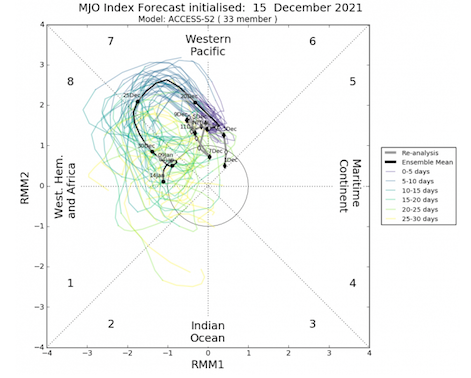
Courtesy of WxBell. The Australian MJO plot....that is a good look.
-
These were published yesterday. Seasonal temps with normal precip in January....we take.


