

Carvers Gap
-
Posts
17,461 -
Joined
-
Last visited
Content Type
Profiles
Blogs
Forums
American Weather
Media Demo
Store
Gallery
Everything posted by Carvers Gap
-
No problem. Man, sometimes I am in the school carline(or just in a hurry) and it looks good on the iPhone, and then looks like hot garbage on a bigger device! LOL.
-
The Atlantic if the CFSv2 is right. If that Atlantic ridge forms, it may force things to back-up in NA and buckle the jet. It is close enough to NAO land that it may well behave in the same manner. The 12z GFS operational was super close to this. Now, as you know, we are dabbling on the edge of the accuracy of computer modeling. So, this is pure speculation on my part.
-
I usually take about 5-10 minutes after each post and make sure it looks/says what I want it to say.
-
Give me a sec....still editing that post.
-
The CFSv2 at 12z reminds me of the 18z happy hour runs prior to the GFS getting its most recent update. Not saying this is going to happen. The possibility is there if the MJO manages to rotate into phase 8 which some members of the CPC MJO model group were flirting with. Maybe there is some strat stuff in play. Yes, I know it will be tough for the below scenario to occur, but it is not without precedent during La Ninas(nor is the warmth without precedent). However, high amplitude 7 even getting close to 8 could force a PNA/EPO ridge to pop. The NAO, fickle as it is to predict, is showing up in modeling now at times. Below is the CFSv2 for early January. Needless to say the departures under that are ridiculously cold. Some of those departures are twenty degrees below normal at the coldest time of the year. Now, the CFS will have a different solution at 18z. Just how that model works. This is a double block....EPO/PNA and an Atlantic block. This is not a forecast. This is spitballing for the upcoming pattern. I don't own a wx blog nor operate any social media for wx. I don't trade in futures nor do anything in the stock market. This forum is pretty much it for me. So, zero reason for me to hype. This is just discussion. This may work out and it may not. The Euro Weeklies...just flip all of the ridges to troughs and troughs to ridges. I should add that BN heights in the SE occur much earlier than this on this particular model. This is just where it goes a few weeks after things switch up. The CFS begins to move pieces around after December 20th by undercutting the ridge with BN heights in the SE.
-
Tagging onto my earlier post, the fronts generally pinwheel in the northern tier of the Midwest and Plains. The development of an EPO ridge, if true, is a significant adjustment by the GFS. The GFS, though often too quick with pattern evolution, will often catch adjustments more quickly than other models once the winter season settles in. One other not with that run, there is a low in the Aleutians instead of crazy AN heights. The CFSv2 could score a coup on this if it verifies.
-
Fairly interesting look on the 12z GFS as it pops an epo ridge around the 17th. A HB vortex then pinwheels cold fronts into the lower 48. Most of the fronts are not overly impressive, but that look can work.
-
Maybe snow tomorrow morning in some of the forum area, and a record high Saturday possible at TRI. Then, maybe "cold chasing rain" snow after the from passes Sunday. @Holston_River_Rambler, great posts.
-
I don't follow them on social media. I don't even Twitter. LOL. Most of the cool tweets I read are from AmWx or @tnweathernutwill keep me plugged-in. I get up in the morning and work through models, usually before I go to any sites just to have an unbiased perspective. May catch some of the Bills game as the weather their is windy and at times snowy.
-
Yeah, those cats are sharp! East based is kind of dry NW flow if we are lucky with a ridge trying to belly in from the southwest. My thinking on that is the east based NAO would hopefully retrograde westward.
-
You know they really aren't that far off right now. Just spitballing, but I think we have a cold shot coming later this month. They are possibly sniffing out a trough amplification(no idea if a pattern change) after the 21st. But yeah, I like 17-18 as my general rule for this winter...but I think we get a second shot of cold this time around due it being a second year Nina and the QBO in our favor. November being cold is a big card. I mean the Weeklies control is stone cold while the mean is warm - not sure I have ever seen the two that opposite. The control just unloads on the forum area with -20F departures at times(and a prolonged cold shot at that). JB made a good point this evening - he noted that the AO and EPO are negative in the means for the 12z EPS late in the run(think it was the EPS but you can check me on that) where they were not at 0z. The Weeklies are derived from the morning run. Would have been interesting to see the Weeklies run from the 12z run. Maybe some light at the end of the tunnel. Let's just hope it isn't a train! LOL.
-
Of course we knew the Weeklies (Euro) would be toasty. I wasn't expecting its control to be exactly (and I mean totally) the opposite for the entire run.
-
I mean is it too much to ask for the Pacific and Atlantic to both be in sync just once every twenty years or so?! LOL. I think the cold is there this year. Just need to get out of the eastern ridge and/or gradient pattern(where the cold is bottled up north of the lower 48). I tend to think the November pattern will repeat in a way that disrupts the overall base-warm pattern. I was reading a post on FB from some folks in western Montana. They are like, "Where is the snow?" It is brown up there when snow pack building should be well under way. I have a feeling that is about to change for them though.
-
LOL. He has been salty lately! I like it though. Jeff shoots straight. I can be just as salty at times. He and @Mr. Kevin are just making sure there is balance to the force. Staring at the big red blob over the Aleutians and eastern NA....Literally, I sit and look at operationals and ensembles and am like, "How long can that feature stay in one place?!" Heck, I am just glad to see it wobble just a bit!
-
Yep. No idea of it happens, but the scenario is a possibility. The 12z GFS shows high latitude blocking galore. The GEFS is well into 7 approaching 8 on the MJO plots of CPC. However, I do urge caution with those as Jeff makes a sound case for it not rotating into 8. That said, Atlantic blocking could offer some relief as it did last winter. Those guys in those tweets have forgotten more than I will ever know.
-
12z GFS...Kind of wonky after d10, but does manage to pop a massive east basted -NAO(loosely defined admittedly). Also, the much discussed ridge lasts about one week. Seems suspicious for it to break down that quickly, and the GFS is often too quick to roll over well established ridges. I use this term a bit to much. But certainly is a break from continuity. The evolution of that pattern is wonky enough to cast doubt upon it. However, it is not without some support from previous CFSv2 runs. Higher elevation snows still showing up for next weekend as well. If I hadn't been watching the big red blob over eastern North America for nearly a week straight in LR modeling, I would actually be ok with that run considering it is only December.
-
You are just preparing for basketball season. LOL. Hey, may be time to talk a little basketball in the banter thread.
-
Thanks for the humbling compliment. Truly, there are many on this sub-forum and other sub-forums who know much more than I do. I learned(and still learn daily) from those folks, and realize each day how little I know(the more that I do this). What makes AmWx so awesome is that it is a collection of people who enjoy the weathe/climater(enthusiasts is a great word), and generally keep it free of the clutter of the rest of this world. We just come here and talk weather which is awesome. We are also truly fortunate to have meteorologists who participate. Hopefully, we can find some cold weather this winter. My wife's family is from northern Ohio! So, nice connection there!!!
-
Thunder in the mountains!!! LOL.
-
John pretty well covered the first potential winter event next weekend which will likely precede an underdetermined period of warmth which follows. The EPS certainly looks like it would kick the trough eastward(if it continue?) late in its run as AN heights move into the GOA. Just to show that we aren't talking out of our minds. This is what the CFSv2 has this morning after a similar set-up (to the EPS) on it. Will be interesting to see which fork in the road modeling eventually takes. I do my best not to talk in absolutes but it can happen. So for now, just presenting two options. The warm option has been well documented. However, I do not think it is a given right now that things turn warm and stay warm through the core of winter. I certainly don't discount that, but certainly can see that the potential for other scenarios exist. Again, my overall winter forecast ideas are warm with January and February being the warmest month. My main contention is that cold(possibly severe at times) will be embedded within those warm means similar to 17-18. IF(stress IF) the AN heights in the Aleutians move into the GOA, this is the potential that exists if that happens. The control is a little later with this evolution, and I think it is certainly possible that the CFS breaks down the eastern ridge too quickly. And again, the CFS is not a model which I trust as it has a cool bias at times. However, with the Euro suite bouncing around about as much as the CFSv2...might as well give it a look.
-

December 2021 Medium/Long Range Discussion Thread
Carvers Gap replied to North Balti Zen's topic in Mid Atlantic
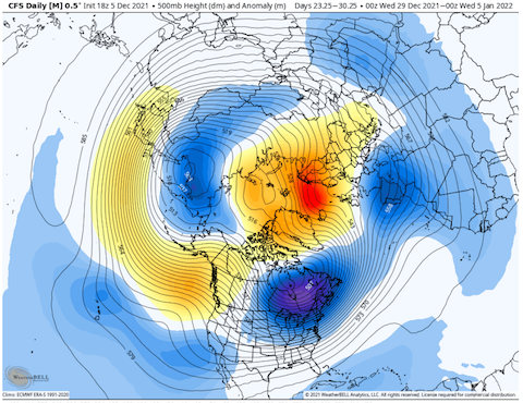
Thanks, PSU, for the great posts. I eventually made a similar map just with a NH view. It is posted in TN Valley thread. I compared it to the 18z CFSv2. I also have added the analogs for the d8-14 CPC LR forecast. Some famous ones and some infamous ones. Been trying to make sense of the Scandinavian AN heights I am seeing showing up in modeling after d10. It is interesting to see a similar feature showing up(on analog maps) in the Scandinavia and/or Ural regions. -
Notice the the three air masses(cold and warm). Actually the December analog package looks similar to our November which we just had. Also, notice the ridge near Scandanavia - as fickle an analog as it may be. Current differences would have nearly opposite 500 features over NA and Greenland. Either we have just left this configuration or we may be headed there. Below is the 18z CFSv2 for the last part of December and first part of January. Not exact but close to the analog maps above.
-
Here are the December composites of PSU's Nina maps. I haven't taken into account which were second year Ninas.
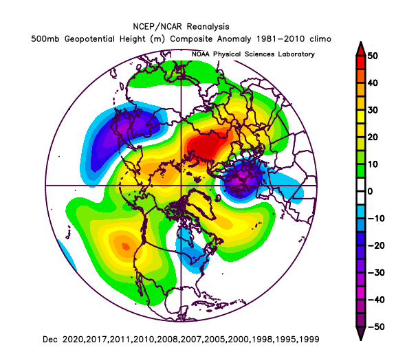
-
Here are the d10-14 analog packages. Some interesting ones in there. Beware, this graphic might change with each update. There are extreme winter analogs (warm and cold) in that package. The best and worst winters I have experience are found in that analog package.
-
I don't think the way to colder weather will be via an SSW though a perturbation of the TPV is probably likely at some point this winter season. Just pointing out that some similar features to those analogs are showing up on current modeling. Pretty cool I think. We will see in time where that leads. I asked in the MA thread if PSU knows how those Decembers looked. I just don't have time to enter those into reanalyses program. If you have time, go for it. Would be interesting to see what a composite of those previous Decembers looked like...


