

Carvers Gap
-
Posts
17,458 -
Joined
-
Last visited
Content Type
Profiles
Blogs
Forums
American Weather
Media Demo
Store
Gallery
Everything posted by Carvers Gap
-

Fall 2021 Thread (September, October, November)
Carvers Gap replied to Carvers Gap's topic in Tennessee Valley
Euro Weeklies in addition to the seasonal CANSIPS, banging the drum for a fairly significant high latitude blocking pattern to develop later this month and into November. Basically, a HB bay block builds into a Greenland block. Euro Weeklies are generally always warm at the surface, but the pattern at 500 is one that would bring significantly colder air at least to the western slopes of the Apps if not all the way to the EC. Huge grain of salt at this range, but there are hints of pattern which could produce BN temps. Would not surprise me at all to see the first snowflakes of the season flying during the first couple of weeks of November. But we will see. That is my "bold" prediction for a soggy Friday morning - meaning seeing some snowflakes during November is not exactly unusual at all and pretty much right on time. -
That would be early. Are early SSWs more favorable for the EC?
-
Torch city. I haven't seen the Euro seasonal yet though, just CANSIPS. The CFSv2 is usually all over the place from run to run. The Euro Weeklies are hinting at some cold pressing SE during the early to mid part of November. My initial thoughts have been for a cold December. HOWEVER, if the cold arrives in early November, we could actually see a thaw at some point in December. LOTS of speculation there on my part as there are several solution paths on the table, and I am only talking about one path in (cold in November). If the cold arrives later in November, that lends itself to a cold December as a whole. Throw in what John is saying and it would look something like this.....cold November ---> thaw at some point during December ---> cold arriving again by mid to late January. What we really don't want to see are the high latitude regions emptied of their cold source during November. Might make it tough to reload, and some models are hinting at that solution. But ya'll know the drill, this is speculation and this could go any of several different directions not mentioned and usually does. Chaos is difficult to predict. When we are discussion things in the 4-10 week range, that needs to be taken (as John notes) with huge boulders of salt.
-
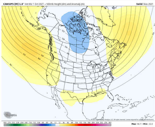
New CANSIPS is showing a very cold pattern for November. Blocking is depicted in EPO and Greenland regions with a deep trough over much of NA. If true, like it or not....our best shot at winter may be very early in the season, but take that with a huge grain of salt.
-
Fall 2021 Thread (September, October, November)
Carvers Gap replied to Carvers Gap's topic in Tennessee Valley
Weeklies (Euro) are showing signs of high latitude blocking towards the end of October. Not sure we want that in place quite yet. Would essentially mean ~6 week blocking episode if we go by 4-6 week pattern cycles. Means mid-Dec could be warm. Way too early to guess that. However, early season blocking might be a good sign for winter...so there is that. Looks to me like the summer heat is gone. -
Fall 2021 Thread (September, October, November)
Carvers Gap replied to Carvers Gap's topic in Tennessee Valley
To echo @John1122 in the banter, starting to see some signs of a temporary breakdown of the EC ridge complex as several storms traverse the western Atlantic and drive the cool boundary every southward. I like it. I like it a lot. -
Fall 2021 Thread (September, October, November)
Carvers Gap replied to Carvers Gap's topic in Tennessee Valley
Spoke way too soon. Models have returned this morning to near record heat for some in the forum area. My point and click is now 93. That is not a record high for Tuesday, but pretty sure it would be fo Wednesday. I don't see a lot of support in modeling for that point and click, but the wx pattern with HP over us definitely supports very high temps. Really hate weather like this during fall. It is not unprecedented, but I still don't like it. -
Fall 2021 Thread (September, October, November)
Carvers Gap replied to Carvers Gap's topic in Tennessee Valley
Other models have finally come back to normal for next week as John noted the extreme temps seem dubious. Need the Euro to back off today, and we may have some consensus for seasonably warm temps vs crazy hot. Temps IMBY have dropped 5-7 degrees since the earlier runs re: next Tuesday. -
Fall 2021 Thread (September, October, November)
Carvers Gap replied to Carvers Gap's topic in Tennessee Valley
The 14th has mid 90s all of the way into northern Indiana on the 0z Euro. The GFS has cooled considerably on this date with its 6z run. Pulling for the 6z GFS at this point. However, the GFS has consistently been showing incredible heat. The Euro just recently jumped on board with a bit of a more modified(but very hot and expansive) heat wave. There are a few solutions that sometimes manage to get a front through during that time frame. 8-9 days out, but not liking the recent majority of runs for that date. Would certainly like to see the cooler solutions verify! -
Fall 2021 Thread (September, October, November)
Carvers Gap replied to Carvers Gap's topic in Tennessee Valley
The 12z Euro yesterday was not cool around the 14th. I have been using that day as a benchmark. The GFS has actually cooled off in E TN. Interestingly, it was the GFS which caught the last warm-up. I truly hope the GFS is wrong. -
Fall 2021 Thread (September, October, November)
Carvers Gap replied to Carvers Gap's topic in Tennessee Valley
Seeing some much AN temps showing up in the d8-10 period - just brutal stuff. This would easily be a record breaking heat wave for someone in the forum area. Really, really hope I am wrong. Looks like the hottest air of the season. Western areas of the forum are in the bullseye for now. Worst of summer appears still ahead. La Nina summers are the worst. -
Well, we are just one season away from winter. Nice to have a respite from the heat this week as the remnants of Ida depart the area. Thoughts and prayers for all of those affected by the hurricane along the Gulf Coast. Rainfall along the far eastern valley has been steady but reasonable - more as you go west I am nearly certain. This morning features light rain/drizzle and very low cloud decks. Lows in the northern valley are supposed to get into the 50s during the next few nights, and that is welcome news! Saw the first evidence of maples beginning to change color this morning. There is this one maple in our neighborhood which always changes first. Some of the dogwoods are beginning to show red in their leaves. Sycamores along the river are showing some yellow. For sure, some of that could be heat stress. Well, it is the first day of meteorological fall. I suspect this season will feature a quick snap to winter time temps late in the season. I am thinking warm early-mid fall, and then a sudden flip to cold. Somebody please fire-up an obs thread and also a banter thread for fall.
-
Spring/Summer 2021 Medium/Long Range Forecast Discussion.
Carvers Gap replied to John1122's topic in Tennessee Valley
La Nina extended summer looks locked-in. That is very counter to what LR models were showing just a few weeks ago. I suspect we see a very sudden flip, but until then....going to be HOT!!!! Some modeling is showing a pattern which gets progressively warmer against the norms. On the bright side, again, I think that might bode well to an early start to winter. Really though, I don't like this pattern all. Of all the patterns I really dislike, this is number one - August extending into September and the first part of October. Boy, I hope I am wrong. -
Spring/Summer 2021 Medium/Long Range Forecast Discussion.
Carvers Gap replied to John1122's topic in Tennessee Valley
First snows of the season are falling in the Big Horns today. Bout' time to create a fall thread........ -
Spring/Summer 2021 Medium/Long Range Forecast Discussion.
Carvers Gap replied to John1122's topic in Tennessee Valley
I think we are very fortunate. Folks in western North Carolina have been slammed. Looks like Carter and Johnson counties are having problems as well. https://www.usatoday.com/story/news/nation/2021/08/19/fred-flooding-missing-people-north-carolina-tornado-warning-northeast/8191424002/ -
Spring/Summer 2021 Medium/Long Range Forecast Discussion.
Carvers Gap replied to John1122's topic in Tennessee Valley
What is crazy is that it rained like crazy here, but barely raised many of the urban streams. On a positive note, my yard turned green almost over night! -
Spring/Summer 2021 Medium/Long Range Forecast Discussion.
Carvers Gap replied to John1122's topic in Tennessee Valley
Headed down to @waltrip country last night in order to get some XC running on their course last night. As soon(and I mean right when we put the truck in park and got out), it started to thunder. So, we got back into the truck to wait, and wait, and wait. Those storms were coming off the mountains heading NW. All it would take would be a little ripple. As soon the storm come off the mountain, it unloaded and trained over east Greeneville. Finally got on the course around 7:15 after about a two hour wait. You can see the same deal on the radar above. As the rainfall descends the mountains - nada. As soon as it hits flat land....rain appears. This is textbook as to why during winter that the valleys do better with storms that come from the GOM. The foothills get the shaft in this set-up though(on the west side....east side gets hammered.) -
Spring/Summer 2021 Medium/Long Range Forecast Discussion.
Carvers Gap replied to John1122's topic in Tennessee Valley
There are two potential rainmakers. The flow from the GOM with Floyd and a potential front late next weekend. MRX has a pretty decent rainfall map on social media. That looks reasonable to me. What will be interesting is whether we get significant rainfall in day6-10. That could be a problem on the heels of Fred. Right now, we could use the rain. -
Spring/Summer 2021 Medium/Long Range Forecast Discussion.
Carvers Gap replied to John1122's topic in Tennessee Valley
I am not seeing the aggressive totals with the Euro or Canadian. Is the American model more accurate with this type of set-up? -
I like this thread today!!!!
-
Great post. I miss those winters. This is an odd flip this time. The QBO never really cycled during the last negative cycle. It left the loop early. It has done the same thing with the positive cycle. It is almost like we are actually entering a true negative stage this time where last time was an off cycle head fake. Will be interesting to see if this current negative trend continues. After many, many normal cycles...it has gone pretty wonky. I don't completely trust it right now, but I definitely like the trend. I would seem this sets the stage for an early start to winter, but I have no crystal ball on that! LOL. I almost feel like this is has the potential to have a 17-18 cold snap which was brutal cold but dry. Oddly, I am a little less worried about cold this winter, and maybe more concerned that precip is sparse. I suspect we may have some chances with NW flow stuff. The new Euro seasonal is banging the drum for a big ridge out west for December and blocking in Greenland which lasts in January. Very much hoping we are at the beginning of a new -NAO cycle.
-
Oddly, 95-96' has a similar flip...just a bit later. 09-10 and 14-15 also have a QBO that flipped almost exactly at the same time as this summer's.
-
@tnweathernutshared this with me today. Take a look at what the QBO has done....gif of guy throwing all of his papers up in the air! LOL. Well, to quote Bob Kesling, "What a turn of events." Check out those last two QBO changes. Not sure many were expecting that. Double digit negatives now for the QBO for June at 30mb. That has my attention. Chaos right there. https://www.cpc.ncep.noaa.gov/data/indices/qbo.u30.index
-
TYS just had its driest month since '95....Man, wouldn't it be nice to see the 95-96 analog pop up this winter?
-
Looks like we managed ~0.25 of rain this evening. Very thankful for the rain. Some area to our east, as has been the case for several months, did very well. Right now IMBY, we are getting rain so infrequently that it reminds me of tracking snow during the winter.

