Carvers Gap
-
Posts
17,460 -
Joined
-
Last visited
Content Type
Profiles
Blogs
Forums
American Weather
Media Demo
Store
Gallery
Everything posted by Carvers Gap
-
TYS just had its driest month since '95....Man, wouldn't it be nice to see the 95-96 analog pop up this winter?
-
Looks like we managed ~0.25 of rain this evening. Very thankful for the rain. Some area to our east, as has been the case for several months, did very well. Right now IMBY, we are getting rain so infrequently that it reminds me of tracking snow during the winter.
-
Normally, when it rains(during a summer with normal rainfall), I don't have to water my garden for about three days. Right now, soil moisture is almost non-existent IMBY. We received about 1.25-1.5" last week during that rain event(got lollipopped here)...had to water within 36 hours as the rainfall was soaked up or evaporated that quickly. With La Nina set to return, very possible this drought could intensify - though that is no guarantee as some La Nina's have produced plentiful rainfall during recent years. That said, drought/heat IMBY is almost always correlated with LaNina conditions. As I noted during spring, when NE TN has BN precip during spring...that is usually a really good indicator that summer is going to be a problem in this area.
-
Yards are beginning to fry up here. Mine is toast. With the heat forecast mid-week and a lack of consistent precip, potentially could get much worse. We have only had three days at TRI which have seen 0.1 or more of rainfall. Two of those days were way back on July 1-2. If we don't score tomorrow, we are looking at a developing drought here. The US drought monitor from last week is picking-up on those conditions in this area.
-
Update on peppers. With the increase in frequency of warm weather and warm nights, we have been blessed with an abundance of both giant Marconi sweet peppers and a poblano peppers(planted those in the hopes of making chile rellenos). The Marconi plant produced so many peppers that if fell over(and pulled the stake out of the ground). We also have had a better crop of cucumbers this year. Went with Spacemasters and Beit Alpha(an Israeli variety).
-
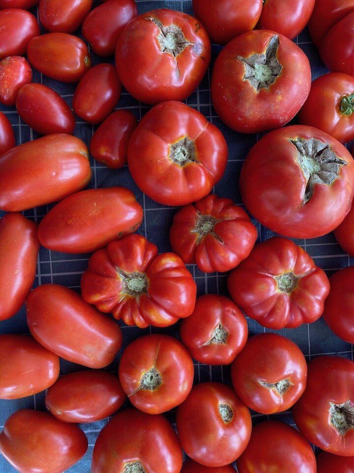
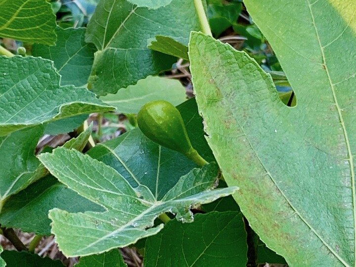
We planted a fig tree this year. Found a great website which is documenting backyard gardens by Italian immigrants. I know we have some NE folks browse this thread from time to time. Would enjoy hearing your stories. Cool thing is they actually have been growing figs and lemons in areas of New York - thinking Long Island. The way they preserve their trees through cold NE winters is nothing short of genius. I have two neighbors who grow figs. One set of neighbors are expert gardeners. The other neighbor, a fine gardener in her own right, has a fig tree which was grown from a cutting by a coal miner in SW VA who was Italian. Growers in NE TN need to simply get a fig tree, and plant it on a south or southwest facing side of your residence, and then do some reading on taking care of it during winter. They are by no means a rarity, but they are also not found in abundance at this latitude. If you see a fig tree in NE TN or SW VA, those folks have either worked carefully to preserve their tree through winter, OR they chose a variety which overwinters well here. We are rookies in the fig tree hobby, but it is very rewarding. So far, deer will not touch the tree. I have heard that deer don't like the sap of established plants. Fresh figs taste incredible. https://www.theitaliangardenproject.com That fig tree, in its first year, decided to produce figs. Pretty cool. Additionally, we have been blessed with probably our best tomato crop ever. We are going to process those into spaghetti/marinara sauce. Despite limited rainfall in TRI, the garden has gone crazy. We installed an irrigation system this year, and it has been worth its weight in gold. The lack of consistent rainfall has actually mitigated disease. BTW, the ribbed tomatoes below are Marsalato Marmande which is a French variety. They are striking in appearance both on the vine and on the plate. Seeds are pricey, but the plants have been very disease resistant with plentiful production.

- 292 replies
-
- 2
-

-
- garden
- vegetables
- (and 4 more)
-

Spring/Summer 2021 Medium/Long Range Forecast Discussion.
Carvers Gap replied to John1122's topic in Tennessee Valley
Since it is kind of a boring wx pattern, though we might discuss the heat in Mountain West and the absolute scorcher that is likely to come to pass. They have already begun to close rivers. Oddly, they had a good snowpack in many places(Wyoming Range), but the water content was very low. Other places had to depend on a wet spring there for additional moisture(to add to deficits). Now, couple low water with hot temps....bout to get bad out there. Looks warm here in the TRI with temps in the low to mid 90s for the next several days. It is going to be HOT!!! -
Spring/Summer 2021 Medium/Long Range Forecast Discussion.
Carvers Gap replied to John1122's topic in Tennessee Valley
The 18z GFS in the front range of the Rockies is torch city with some temps approaching 110F+ in the medium range. Man, I hope that is not coming this way. Yikes. -
Received some much needed rainfall yesterday afternoon/evening. Looks like I got lollipopped to the tune of 1.5." Water was ponding on the baked ground. We had places where 1-2" of water was on dry, brown grass. Looked really odd. Anyway, everything is much greener today but the humidity is wicked.
-
Powell, awesome to hear!!!!
-
Kind of an interesting "opposite" to my my recent post. The CFSv2 is picking-up a Greenland Bock for early fall. If that occurs(and it doesn't bridge into an E Coast ridge) that is a great sign for those of us who like seasonal fall temps. I think climatology supports a warmer fall, but right now, I am not seeing that in all LR modeling. The Euro is nearly opposite of the CFS suite. So tough call this far out. The Euro has a really bad bias of being too warm in its Weeklies forecast. However, American modeling is often too cold. Split the difference, and you get seasonable temps. That said, if the American suite scores a coup(and correct me if I am wrong, but I "think"it picks up on Greenland blocking a bit better at range), extended summer would not occur. So bottom line, nothing is a slam dunk this far out, and while climatology(building La Nina) supports extended summer, one wonders if we can actually sneak through fall without the atmosphere responding to the Nina. I have learned not to discount the CFS of late.
-
Have to agree with Cosgrove, thinking fall is looking much warmer than I thought a few weeks ago. Anyone for another extended summer?
-
We had a nice rain shower this AM. It really soaked things. Thankful for that!!!!
-
Yeah, it has been crazy. I can probably drive 20 minutes and find similar departures. When this finally breaks, probably going to have more than we want!!!
-
0.08" of rain during the last 11 days. Pretty sure on the day where excessive rainfall was a potential that MBY got zip. Through nearly mid-July, there is potential for July to finish as TRI's fourth straight month w BN precip.
-
All the time. I-81 is kind of the demarcation line. East of that is generally a slight upslope until JC, and then of course one hits the Smokies. West of the interstate is more of a downslope. Part of what is going on right now might be that NE TN is sitting just close enough to a Bermuda high that precip is just running out of gas as it hits it. You can really see that on how the line this evening is forecast to dissipate just to the east of TRI.
-
Yard looks great, Powell! Finally received some rain last last evening. It wasn't a lot(I don't think), but it was enough to keep the garden watered. Looks like today there is actually a chance for excessive rainfall in NE TN per NWS/MRX on FB.
-
Have barely had a drop here this week. Yards reflect this. I-81 eastward has not done as poorly. We have had a three minute "shower" which didn't even get the pavement under trees wet. Moisture was gone within minutes. Hopefully we can score some rain this weekend. The irrigation system in my garden is now paying dividends in this dry weather here.
-
TRI is 1.9F BN for temps so far this month. We take!!! Have had a few nights with temps in the mid 50s. We take!!!
-
Rain has been dodging MBY all summer. It did again today. Temps were pleasant though with some light drizzle/rain drops early with about a 60 second shower this afternoon. Swing and a miss today, but like John said...no complaints about the temps!!!!
-
For now, as it did similar last summer....The Euro likes the West to be under a stout ridge.
-
The Euro is in which runs out to six months which means it gets us to January. It has a full latitude trough running from the Rockies to the western Atlantic. Looks like it has a fairly strong EPO signal with a warm Alaska. Hopefully everyone knows the drill....huge grain of salt since this is July. Just thought I would share.
-
Here is a nugget from the CANSIP monthly forecasts(BTW, it is usually blind to cold outbreaks so TIFWIW). It develops a -PDO(DJF) in conjunction with what looks like a La Nina which is displaced westward. That is torch city for our area IMO. Now, it could be wrong. ENSO forecasts have some skill at this range, but I have been burned many times in early to mid summer by an ENSO forecast that flopped. -PDO combined with La Nina is pretty much a ridge over the E and SE. No idea if the CANSIPS is correct. It does say that if we get winter Nov/Dec are our best options IMHO. Hopefully I don't have any of that backwards. @nrgjeff, does that seem right or am I oversimplifying this?
-
Spring/Summer 2021 Medium/Long Range Forecast Discussion.
Carvers Gap replied to John1122's topic in Tennessee Valley
@Blue Moon, new forecasts(for each month) should begin to roll tomorrow with the CANSIPS being first and the Euro a few days later. Whew, been like a hair dryer in NE TN for the past couple of days. Steady winds and hot temps. It is drying everything out. Crazy that we are actually under a flash flood watch tomorrow!!! Need some rain big time here. We have been flirting with "abnormally dry" on the drought monitor for about a month(off and on). Everyone east of 81 got a great dousing of water a couple of days. Nada IMBY. -
Man, just be glad you weren't in Eugene, Oregon, last week!!! The West has actually had incredible winters during the past decade in the northern Rockies and front range. The East is due, just not sure this is the year while fighting a La Nina. But who knows. I do think the IO firing in unfavorable locations of the MJO(unfavorable if one likes winter) is really throwing a wrench in things. @nrgjeff has been all over that. Bet it is a strong key this winter. I am just not sure if one can predict its frequency and intensity during the middle of summer, or I would have mentioned it.