AfewUniversesBelowNormal
-
Posts
4,753 -
Joined
-
Last visited
Content Type
Profiles
Blogs
Forums
American Weather
Media Demo
Store
Gallery
Everything posted by AfewUniversesBelowNormal
-

Clouds - 2018
AfewUniversesBelowNormal replied to bowtie`'s topic in Outdoor and Weather Photography
This is a good thread. Clouds are so different now. I remember large cumulonimbus in the 1990s here in Maryland. Even on Sunny Sunday's it was a sky full of fluffy cumulus 80% of the time. Now it's these wispy clouds, saturated raindroplets. Someone said the earth has more water/ice now, but I think there is less rainfall. -
2018 Mid-Atlantic General Severe Discussion
AfewUniversesBelowNormal replied to Kmlwx's topic in Mid Atlantic
Not really close. For the eye to pick up 50-200 unique strands on a single bolt is pretty incredible imo. If you want to talk, these are just averages. The real story is the temporary balance (in high-low pressure?) the storm caused. -
2018 Mid-Atlantic General Severe Discussion
AfewUniversesBelowNormal replied to Kmlwx's topic in Mid Atlantic
Most powerful storm of my lifetime happened last year and I actually got struck by lightning. 20-50 branches of real lightning was striking every 1-2 seconds. Multiple pulses, dark swirling clouds, all. Besides that, the climate for severe weather has really changed in this area since the early 2000s. For example, it's almost May and there hasn't been a storm and it really hasn't been close. It has been a cold pattern but where are the cumulus clouds? In the 1990s it was also much different. -
Arctic Sea Ice Extent, Area, and Volume
AfewUniversesBelowNormal replied to ORH_wxman's topic in Climate Change
-
Neutral
-
Models bring back -PNA in Pacific now. You don't see this in new developing El Nino's
-
Definitely El Nino, subsurface is leading indicator
-
Mid to Long Term Discussion 2018
AfewUniversesBelowNormal replied to Cary_Snow95's topic in Southeastern States
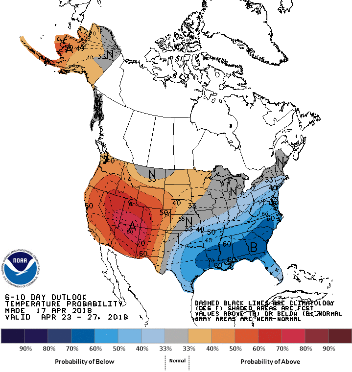
It will probably be an above average temperature Summer. -
I remember someone said the Kelvin wave during La Nina as strong as preceded rises to at least +Neutral even though the net effect was a cooler, more La Nina-like subsurface. And a monster -PNA for a few weeks. I thought this was interesting because it verified, the subsurface warming in the east is movement from that Kelvin Wave. It happened before the La Nina peaked is my point.
-
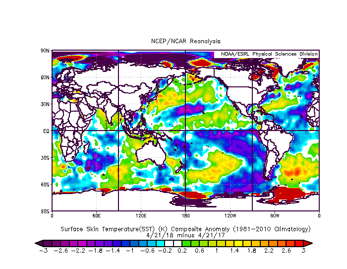
I always always make the point that the subsurface is a better indicator than the surface. This is yet another example of it. The Northern Hemisphere is transitioning to El Nino now, with the subsurface Ninoish and the surface not. Subsurface is +3 in El Nino-warm area, and Nino 3.4 is still negative
-
Mid to Long Term Discussion 2018
AfewUniversesBelowNormal replied to Cary_Snow95's topic in Southeastern States
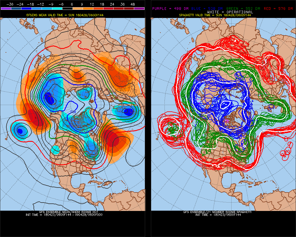
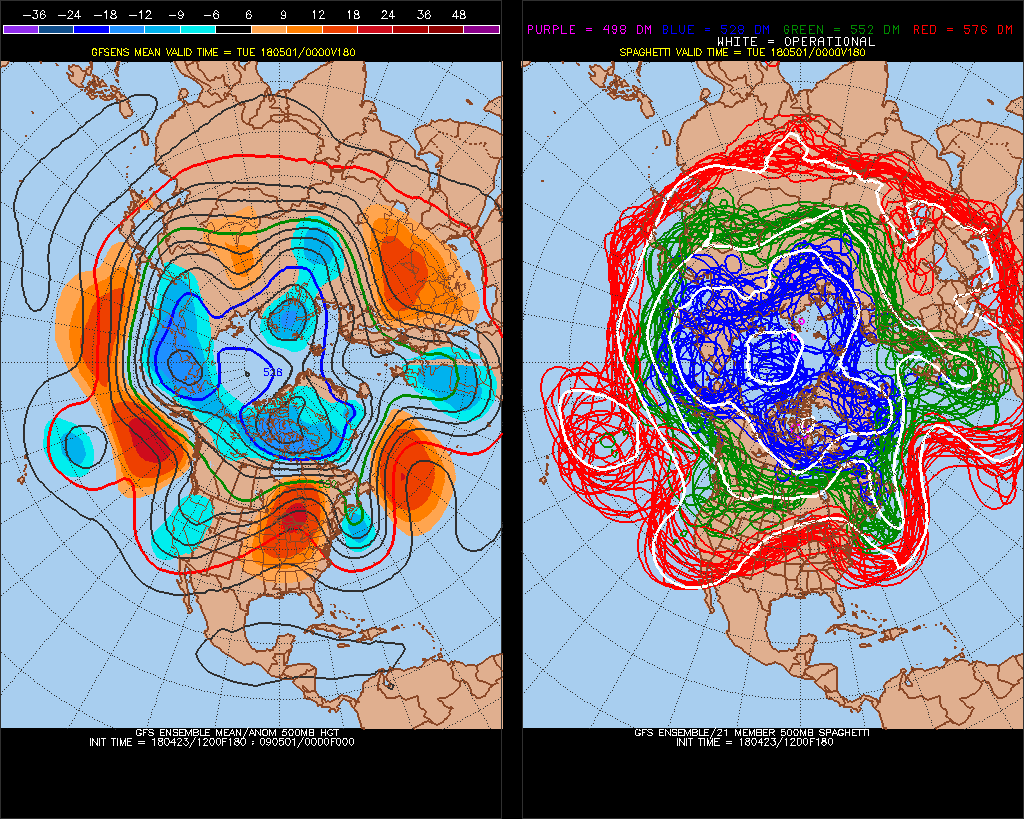
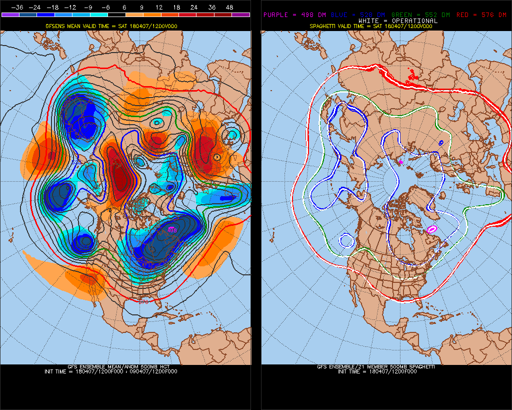
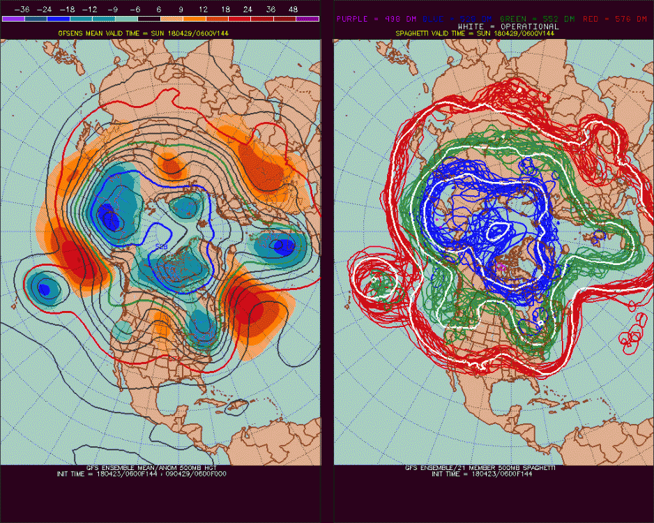
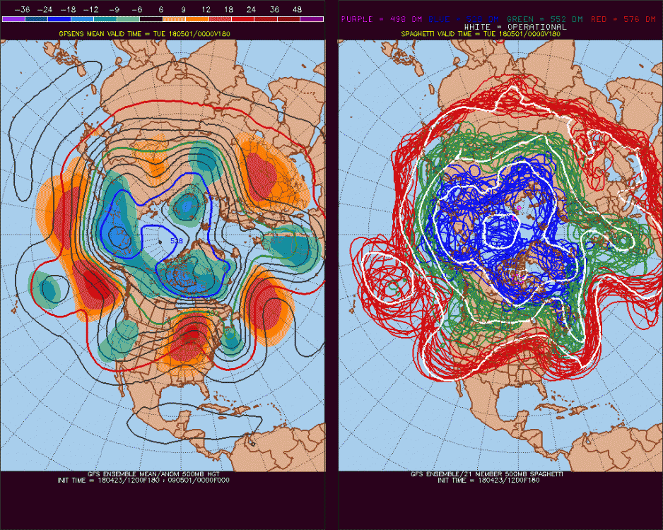
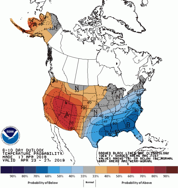
Check out the progression of storm 4-20 to 4-23, very El Nino-ish -
Mid to Long Term Discussion 2018
AfewUniversesBelowNormal replied to Cary_Snow95's topic in Southeastern States
There is a pretty good signal of negative North Atlantic Tripole right now. Historically, the Spring is a great time to correlate Atlantic SSTs with hurricane season activity. 1969,1995, 1998, 2005, 2010 were the highest +NTA Spring's and the average #storms for these years is about 20. El Nino also looks like a sure things, so I'd go over/under on number named storms 12. -
I think it will be a basin wide El Nino. Right now it looks like Weak El Nino, but odds of Moderate aren't far behind. Very low chance for strong, ~5%
-
Yup, good call. I stated in the initial post 500mb was measurement for this, because that is the SST correlation.
-
Subsurface is a good indicator in April/May 85% chance this crosses Weak El Nino threshold in the weeklies by the Summer
-
2013 was major climate change
AfewUniversesBelowNormal replied to AfewUniversesBelowNormal's topic in Climate Change
-
Subsurface trends early 2018 has 7 analogs.. 3 went El Nino, 4 were Neutral. The way it's going, I would guess Weak or low end Moderate El Nino as a max, about the same % chance for Neutral, and slight chance we go back to Weak Nina in the Fall. Hurricane season is probably active with a lot of US misses.
-
Neutral NAO, but really I might call this slightly negative
-
2013 was major climate change
AfewUniversesBelowNormal replied to AfewUniversesBelowNormal's topic in Climate Change
-
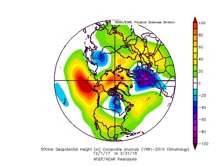
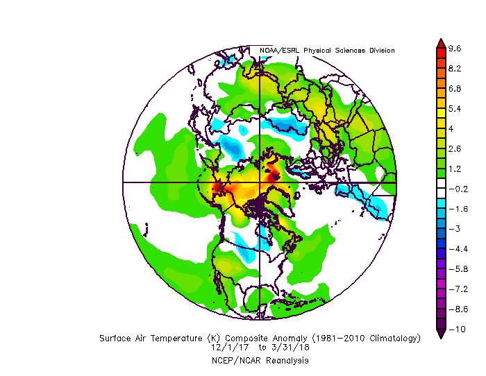
Hadley Cells expanded north, Polar Vortex shifted
-
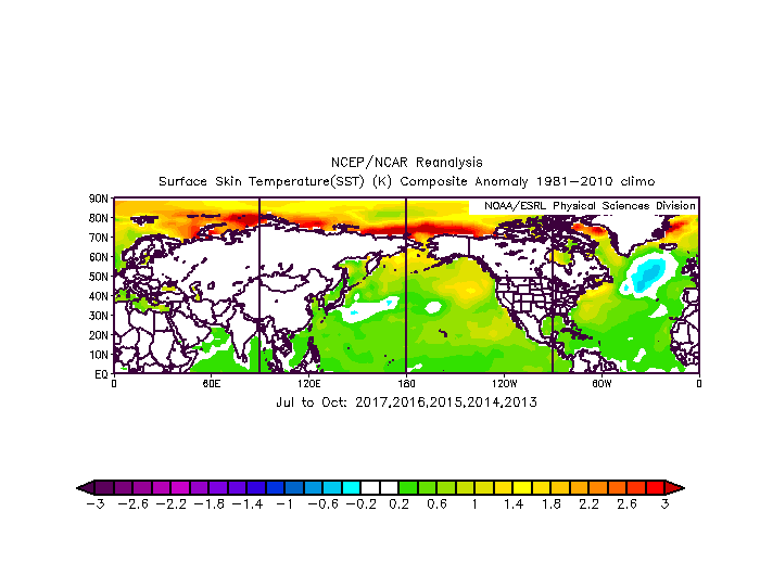
Next year might be El Nino so that would be interesting with how warm N Hemisphere SSTs were this Winter.
-
Southeast Sanitarium - A Place to Vent
AfewUniversesBelowNormal replied to Jonathan's topic in Southeastern States
I would think in a 1000 year period the largest snowfall would happen in the Southeast, US. probably Florida -
Spring/Summer 2018 Banter and Complaint Office
AfewUniversesBelowNormal replied to IWXwx's topic in Lakes/Ohio Valley
Definitely warm when breaks