

AfewUniversesBelowNormal
-
Posts
4,753 -
Joined
-
Last visited
Content Type
Profiles
Blogs
Forums
American Weather
Media Demo
Store
Gallery
Everything posted by AfewUniversesBelowNormal
-

Mid to Long Term Discussion 2018
AfewUniversesBelowNormal replied to Cary_Snow95's topic in Southeastern States
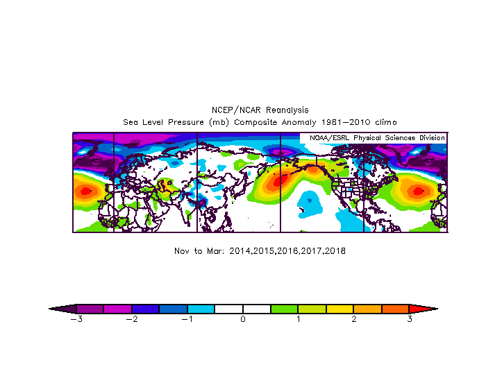
Looking really good for Winter. Weak El Nino and huge bias for Hudson Bay-south trough/+PNA/-EPO pattern right now, the Summer through... -
2018 Mid-Atlantic General Severe Discussion
AfewUniversesBelowNormal replied to Kmlwx's topic in Mid Atlantic
What an awful year for storms. The worst, probably ever. The air has this constant ice-cube-like tint. Call it natural or whatever, I think it's a reason for the clouds. -
Updating my prediction to Weak El Nino peak. The cold in the subsurface near 180 degrees is concerning for stronger than +0.8 ONI trimonthly high.
-
Check out this strong +PNA which you usually don't see in La Nina, 52-46-2 (Nino-Neutral-Nina). Then the NAO is positive and this whole evolution is really developing-El Nino-like http://mp1.met.psu.edu/~fxg1/ENSHGTAVGNH_18z/ensloopmref.html
-
It goes something like every event that has broke in June-July peaks in October-November or later. Subsurface looks like a 2 month warming at least.
-
Coldest wind chill by state
AfewUniversesBelowNormal replied to beavis1729's topic in Lakes/Ohio Valley
The upper midwest one's aren't that impressive. -50 in Chicago? Big deal. I bet the further south has some better extremes. I bet the western 1/3 of the country has some better extremes. -
Yeah, not a big deal. More -PNA duality than anything else. Surface SST trend doesn't necessarily correlate to North Pacific +PNA, although sometimes shown on models. Easy 3-5 day bias-correction I think
-
There's been two substantial anomalies in April and May. On Feb 21, 2018 when Washington DC had 500mb heights of 591dm, breaking its old record of 583, there was a major PV in this area.
-
2013 was major climate change
AfewUniversesBelowNormal replied to AfewUniversesBelowNormal's topic in Climate Change
Hadley Cell Atlantic, Hadley Cell Pacific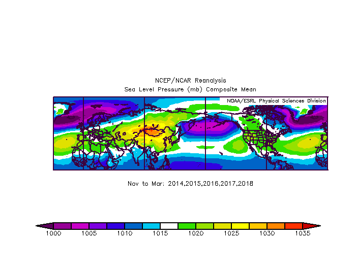
-
Mid to Long Term Discussion 2018
AfewUniversesBelowNormal replied to Cary_Snow95's topic in Southeastern States
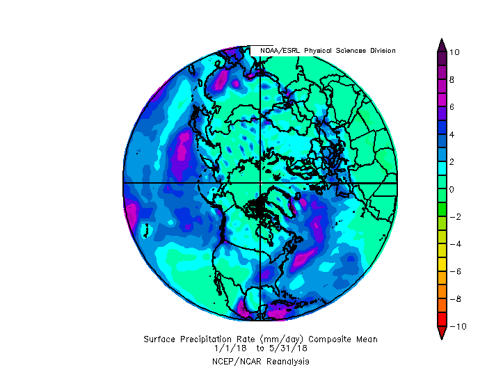
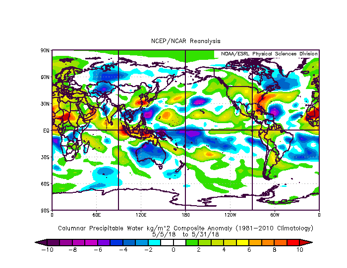
A lot of water in the Hemisphere right now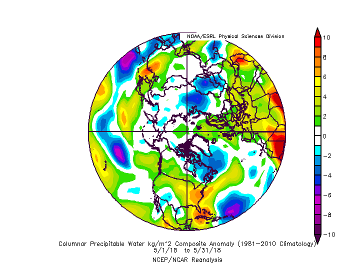
-
Blizzard of 93 conditions have been building as a potential energy over the south part of Greenland for the last few months and years. Not really related, but a cool point. I can see this potential energy hitting the northeast in a few years as either a hurricane or storm.
-
When the subsurface warm pool reaches a peak in surface warming, it looks like a GOA Low is on models. I wonder if this will happen. (I think not)
-
I mean, the most named storms ever in El Nino is 15 (2004) and second is 12 in 11 years (Since 1978. The 1960s went higher)
-
Thanks. This is the subsurface data for May. 2018 5 0.73 0.76 0.89 Opp: 2016, 2010, 1998, 1995, 1992 For: 2012, 2011, 2009, 2006, 1997, 1989 7/11 chance El Nino (CPC ONI) (but it's really about 90%)

-
It could be one of the best Winters in a while
-
This means subsurface temps in the central region will continue cooling, which probably means the events remains Weak or goes back to Neutral in the Fall.
-
Tao/Triton maps are warming rather rapidly. +0.5 pool
-
The surface is warming pretty rapidly now. We'll be able to see it in about a week.
-
Mid to Long Term Discussion 2018
AfewUniversesBelowNormal replied to Cary_Snow95's topic in Southeastern States
Here comes El Nino -
Surprised so many high guesses, the AMO is cold and we are going into El Nino most likely. I can see 13-7-3, something like that.
-
Some +3> subsurface anomalies are getting close to the surface and Nino 3.4 has made switch to positive. Maybe in a few weeks.. AMO should start to warm soon, wonder if this will create a sea-saw effect with ENSO (spurring Nino). Medium term models are La Ninaish for the Hemisphere.
-
2018 Mid-Atlantic General Severe Discussion
AfewUniversesBelowNormal replied to Kmlwx's topic in Mid Atlantic
No, we haven't. This is like 175% water after ice cubes melt, in the air and stuff. It's not thunderstorm producing.- 1,302 replies
-
- 1
-

-
- severe
- thunderstorms
- (and 3 more)
-
Now the modeled pattern is shifting a little bit. I think more in an AMO thing though.
-
So check it out, subsurface negative trend in the center of subsurface regions, and big -PNA

