LongBeachSurfFreak
-
Posts
9,479 -
Joined
-
Last visited
Content Type
Profiles
Blogs
Forums
American Weather
Media Demo
Store
Gallery
Everything posted by LongBeachSurfFreak
-
 I remember we tried to go sledding at cedar creek and you couldn’t walk up the hill. That’s some serious ice accretion!
 -
A huge ice storm is my worst nightmare for snow removal. Luckily the last big one was way before my time. They happen, but are rare near the coast. I’ll never forget the look of the trees in the sun after the 94 ice storm.
-
It’s been a nightmare of a snow removal event do to the ice and duration. Our crew is shot. Nothing worse than a glaze of ice and temps around 20. Salt becomes increasingly ineffective when the temps are 20 or below.
-
Still all snow uws, I’m exhausted I have been up all night doing snow removal. I would estimate 2” here a few miles north of the park.
-
93/94 wasn’t as great right at the coast. I remember taking the bus home from wantagh middle school up by the southern state in snow and hitting Merrick road and it was raining. One of my earliest weather memories and what got me fascinated with Long Islands weather. Could easily see that tomorrow morning.
-
While you are right on the money about nor’easters, those are worse for the north shore and Jersey. These have been cutters with SE winds and have had extremely large fetch’s. That’s why south facing beaches are getting rocked. It’s really a serious situation. Our life guard shack at Jones beach which was obviously rebuilt after sandy, hasn’t flooded since. Well it had feet of water the last storm. Meaning all the equipment we store over winter is screwed.
-

-
The beaches can’t even take the next storm. Im currently watching the pacific blvd cam and and the waters to the boardwalk. All that sand added after sandy is gone.
-
We are both lynbrook guys now, and we for sure had at least a half an inch during the last storm. Im right at the northern tip of lynbrook. But the yard was def snow covered for a bit. So we aren’t striking out so to speak.
-
Well at least you get to see snow now that you moved. What’s terrible stretch for the island. Hopefully our one shot at redemption next week.
-
1/9-1/10 Now Morphing to Less-Than-Exciting Power Cutter
LongBeachSurfFreak replied to Torch Tiger's topic in New England
Exactly. It’s the extremely long fetch. Which builds wave periods above 14 seconds. Something usually only seen on the west coast. The next storm is going to cause big erosion issues. On par with 10/91 and 12/92 -
Another intense Great Lakes storm late Friday 1/12 with the brunt of 1" rain/shore gusts ~50 MPH Friday night, followed by widespread west gusts 40- possibly 50 MPH late Sat-Sun 1/13-14/2024. This serves as the OBS thread late Fri onward.
LongBeachSurfFreak replied to wdrag's topic in New York City Metro
Check out the beaches, it’s getting really really bad. These storms have these huge Se fetch components. Which build enormous high period swells. This next storm could be the knock out blow for allot of places, especially fire island.- 90 replies
-
- 1
-

-
- flooding rains
- damaging wind? squalls?
- (and 2 more)
-
Two Mdt to high impact events NYC subforum; wknd Jan 6-7 Incl OBS, and mid week Jan 9-10 (incl OBS). Total water equiv by 00z/11 general 2", possibly 6" includes snow-ice mainly interior. RVR flood potential increases Jan 10 and beyond. Damaging wind.
LongBeachSurfFreak replied to wdrag's topic in New York City Metro
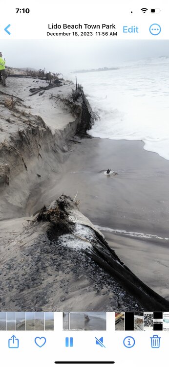
Just monumentally bad beach erosion today.- 3,610 replies
-
- 3
-

-
- snow
- heavy rain
- (and 5 more)
-
Two Mdt to high impact events NYC subforum; wknd Jan 6-7 Incl OBS, and mid week Jan 9-10 (incl OBS). Total water equiv by 00z/11 general 2", possibly 6" includes snow-ice mainly interior. RVR flood potential increases Jan 10 and beyond. Damaging wind.
LongBeachSurfFreak replied to wdrag's topic in New York City Metro
Very very severe beach erosion from what friends are telling me. Our life guard shack at Jones beach didn’t flood during the last storm but now has feet of water. As soon as I leave work at 2 I’m headed to lido, Long Beach. It’s gotta be terrible there. -
Two Mdt to high impact events NYC subforum; wknd Jan 6-7 Incl OBS, and mid week Jan 9-10 (incl OBS). Total water equiv by 00z/11 general 2", possibly 6" includes snow-ice mainly interior. RVR flood potential increases Jan 10 and beyond. Damaging wind.
LongBeachSurfFreak replied to wdrag's topic in New York City Metro
Watching all the Surfline premium cams currently as it’s high tide and my God the beaches are being destroyed. It’s another super long fetch event.- 3,610 replies
-
- 1
-
-
- snow
- heavy rain
- (and 5 more)
-
Two Mdt to high impact events NYC subforum; wknd Jan 6-7 Incl OBS, and mid week Jan 9-10 (incl OBS). Total water equiv by 00z/11 general 2", possibly 6" includes snow-ice mainly interior. RVR flood potential increases Jan 10 and beyond. Damaging wind.
LongBeachSurfFreak replied to wdrag's topic in New York City Metro
That line was nuts on the uws strongest winds since Isias- 3,610 replies
-
- 1
-
-
- snow
- heavy rain
- (and 5 more)
-
Two Mdt to high impact events NYC subforum; wknd Jan 6-7 Incl OBS, and mid week Jan 9-10 (incl OBS). Total water equiv by 00z/11 general 2", possibly 6" includes snow-ice mainly interior. RVR flood potential increases Jan 10 and beyond. Damaging wind.
LongBeachSurfFreak replied to wdrag's topic in New York City Metro
I’ll be there in two hours. -
Two Mdt to high impact events NYC subforum; wknd Jan 6-7 Incl OBS, and mid week Jan 9-10 (incl OBS). Total water equiv by 00z/11 general 2", possibly 6" includes snow-ice mainly interior. RVR flood potential increases Jan 10 and beyond. Damaging wind.
LongBeachSurfFreak replied to wdrag's topic in New York City Metro
It’s basically a super abrose jet event. This will sting.- 3,610 replies
-
- 1
-

-
- snow
- heavy rain
- (and 5 more)
-
Yeah, it was actually a legit emergency where I grew up. Busses couldn’t leave until the tide dropped and forget about parents in cars and station wagons in the days before SUVs. I remember being stuck for hours at mandalay elementary in wantagh as a 5th grader. Not to mention the winds were on par with sandy. That roar you never forget of hurricane force gusts.
-
Two Mdt to high impact events NYC subforum; wknd Jan 6-7 Incl OBS, and mid week Jan 9-10 (incl OBS). Total water equiv by 00z/11 general 2", possibly 6" includes snow-ice mainly interior. RVR flood potential increases Jan 10 and beyond. Damaging wind.
LongBeachSurfFreak replied to wdrag's topic in New York City Metro
That’s another monster fetch you just don’t see on the east coast. Major to extreme beach erosion is a lock, as tides are higher than the last event and this looks stronger.- 3,610 replies
-
- 1
-
-
- snow
- heavy rain
- (and 5 more)
-
Two Mdt to high impact events NYC subforum; wknd Jan 6-7 Incl OBS, and mid week Jan 9-10 (incl OBS). Total water equiv by 00z/11 general 2", possibly 6" includes snow-ice mainly interior. RVR flood potential increases Jan 10 and beyond. Damaging wind.
LongBeachSurfFreak replied to wdrag's topic in New York City Metro
- 3,610 replies
-
- 1
-
-
- snow
- heavy rain
- (and 5 more)
-
Two Mdt to high impact events NYC subforum; wknd Jan 6-7 Incl OBS, and mid week Jan 9-10 (incl OBS). Total water equiv by 00z/11 general 2", possibly 6" includes snow-ice mainly interior. RVR flood potential increases Jan 10 and beyond. Damaging wind.
LongBeachSurfFreak replied to wdrag's topic in New York City Metro
I was just looking at buoy obs from down south and wow, there have been some seriously strong winds for a winter storm down there. 64 knot gust just south of Alabama. Seas are also pushing 20’ in the gulf. I think this is a real wind threat this time.- 3,610 replies
-
- 2
-
-
- snow
- heavy rain
- (and 5 more)
-
Two Mdt to high impact events NYC subforum; wknd Jan 6-7 Incl OBS, and mid week Jan 9-10 (incl OBS). Total water equiv by 00z/11 general 2", possibly 6" includes snow-ice mainly interior. RVR flood potential increases Jan 10 and beyond. Damaging wind.
LongBeachSurfFreak replied to wdrag's topic in New York City Metro
I’ll never forget being on the Long Beach boardwalk during March 10. Legit 70mph gusts will throw you around. I’m sure there was some intensity increase because of the buildings but it was unforgettable experience. Only other times I experienced winds of that magnitude were December 92 and of course sandy. I’m thinking more like 60mph here.- 3,610 replies
-
- 1
-
-
- snow
- heavy rain
- (and 5 more)