LongBeachSurfFreak
-
Posts
9,504 -
Joined
-
Last visited
Content Type
Profiles
Blogs
Forums
American Weather
Media Demo
Store
Gallery
Everything posted by LongBeachSurfFreak
-
.03” at the wantagh mesonet. Winner winner or loser loser. Makes up for Saturday. .
-
Outflow in the southern semicircle is impressive. Almost looks like half a major .
-
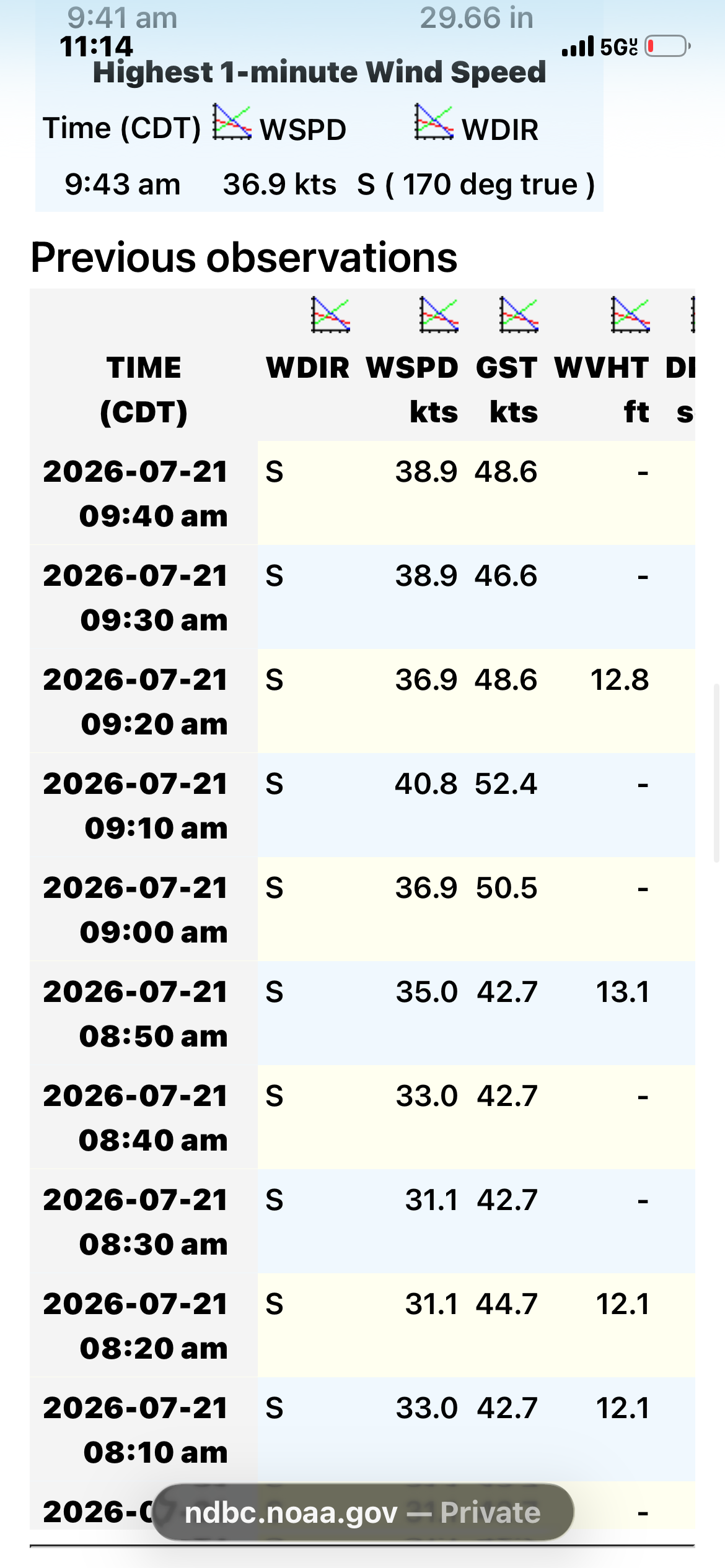
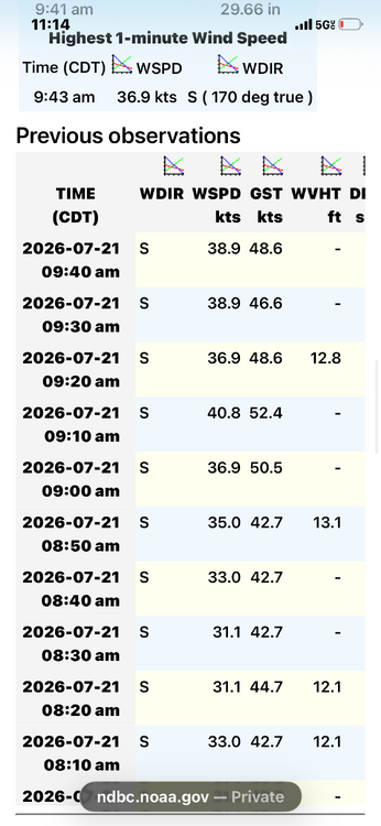
Very solid buoy obs .
-
The wind is already blasting onshore at jones beach, so we are going to have instability issues here. .
-
Well said, it’s a gorgeous beach day. .
-
I was surprised driving home from the beach that there wasn’t a leaf out of place once north of merrick road. Down on the barrier island the few trees there are, which are very used to wind had branches and leaves down everywhere. Signs blown down all over the park as well. Fits with a localized microburst. .
-
We actually have damage in the park. Maybe a wet micro burst .
-
Absolutely insane storm at jones beach. Zero vis and at least 60mph winds. Definitely need a severe thunderstorm warning .
-
Round two is incoming for the south shore. Constant thunder at jones beach currently .
-
That’s always been the bullseye for this event and historically. .
-
That cell is incredibly unusual. Vis down to less then a mile now at jones beach .
-
Typical boreal stuff like black spruce, red spruce, balsim fir and birch’s. Maybe a few hardwoods mixed in because it’s not that far north like sugar and red maple. .
-
Vis is pretty low at jones beach right now despite a minor sw sea breeze .
-
Hottest day of the summer at jones beach with the wind Nw. We lucked out during the last heatwave with just enough onshore component. .
-
Low of 81 at LGA, the king of the heat island. Still a decent Southerly vector to the wind should keep the beaches reasonable today .
-
Ok I’m not here for an argument and I do not want to pull radar loops. But that enhanced area that came off New Jersey only scrapped jones beach and not the rest of Long Island. Regardless I do not have a rain gauge at JB but I had a measly quarter inch when I got home to lynbrook. My go to with jones beach is when the administration parking lot floods. We had some water coming out of the sump today but just barely in the lot. .
-
Where are these stations? 5 miles south or more then any inhabited land. Rain trained right along the barrier islands. .
-
Consistent moderate rain with rumbles of thunder at jones beach. Have to be near an inch here .
-
Seems to break apart heading east. Currently light rain at jones beach .
-
Good point. Areas that had been dry did especially well during the last heat wave. JFK is a great example. .
-
Nice let’s break the trend of one a done 100 heat waves. .
-
My bootleg gauge (I need to get a legit one) had 3.5” just now. Biggest event here in Lynbrook in over a year. .
-
Over 2” in sw Nassua now. Rates have been consistently below what’s needed for real flash flooding. So it’s mainly a much needed good soaking .
-
Alternating between moderate and heavy in sw Nassua. Looking good for at least 2” .
-
Jones beach air show cancled, for what so far has amounted to nothing more then light showers on the south shore of Nassau. .