SnowGoose69
-
Posts
16,752 -
Joined
-
Last visited
Content Type
Profiles
Blogs
Forums
American Weather
Media Demo
Store
Gallery
Everything posted by SnowGoose69
-
Yeah that total always baffled me. I have no idea how they managed to come up with that one
-
Yeah I forget when they moved it. My guess is probably 1996. I was also told once snow measurements prior to the 93-94 winter are questionable (yeah we know they are questionable after too lol) but the reason told to me was they used to measure somewhere downstairs from the NWS office up til 92-93 and the measurements were likely too low most times
-
Its probably safe to assume the Saturday FROPA will be later than currently shown...most models consensus is near 21-02Z but in summer its rare models at this range are not about 12-18 hours too fast. If true it probably will lower potential of severe if its Sun AM vs Sat eve
-
They cut away a ton of the junk around it too so I have wondered if maybe more its a sensor issue now
-
89 now at NYC. Would think a good chance 90 happens
-
If the extended HRRR is right Wed could be mainly dry and it pushes fairly far east. The RGEM/Euro are furthest west overall.
-
88 now but still not accurate
-
Given it is likely to be a similar La Nina to last winter that is unlikely
-
Will be pretty funny to see LGA go to like 85 when winds shift SW ahead of the front
-
As I said yesterday this bore some resemblance to 12-11-93...difference is no negative tilt this time so the snow band is going to rotate through quickly. Interesting how in both cases almost 30 years apart the models did not see the snow correctly associated with the vort/trof and incorrectly placed too much precip earlier.
-
A retired met always used to tell me that rain to snow events here where you see significant sleet or snow mixing in when you’re still 38-39-40 often turn out to be much worse than expected. We’ll see if he’s right. I still don’t expect more than 2 near the city
-
Models do not diverge til 14Z or later so really won't be able to get a sense where this is going til then. The RGEM may be a nose too slow at 04z over PA progressing the cold air E but its not a huge amount. I still think the faster progression of colder air will verify...there could be a period of PLSN or RAPL perhaps near the city and the HRRR does show that
-
It was a very east based -NAO if I remember right, the block was by Iceland
-
That was a coastal low with a closed low at 500...that is the only way you can ever see backend snows here with a coastal low, otherwise the system exits too fast and or the cold air does not come in fast enough
-
This event is somewhat similar to 12-11-93 but the main difference which will prevent the bigger snows from being near the coast is that you had a more notable neutral to negative tilt to that system. As a result you had a good 6-9 hour period of snows and your flow both at the surface and aloft was more NNE vs NW so there was no notable downslope impact.
-
The RGEM often times in scenarios where your CAA is coming on a NNW-N trajectory is way too slow bringing in the colder air...this event is atypical to many of the anafrontal snows we have seen in recent years where we got our cold air on a NW push...those always take forever and often models are too fast bringing them in. The difference in a 320 push vs 350 is night and day. The issue I still see though is 20-23Z I do not buy any meaningful snow in areas where downslope is a factor so basically most of the area except the NW...you'll see 17-19Z as the window for snow near the city and that is probably all with just flurries after...the 3km NAM idea post 19z I think due to the NW component is overdone
-
If temps are marginal it will be too high usually...it showed 2-3 mean across whole area last event which was obviously too much...it has 1-2 from NYC to the Suffolk border and 2-4 NYC west with some 4-5 inch areas Orange County and NW NJ
-
The RGEM really sucks in anafrontal type scenarios or where you have incoming cold air...it usually is way too slow bleeding it in...the changeover will probably be closer to what the NAM or HRRR shows but I still do not expect much snow near the metro once you have the gradient flow through 700 being most NW...the HRRR shows snow 20-23Z in NYC but reality is that would be flurries...the period from 17-19z when you're more NNE or N is when you'd see your snow. Any sort of NW flow in a rain-snow scenario here never pans out...you need to be N-NE
-
The RGEM/NAM are probably too far west if you ask me but I still do not like the setup anyway near the coast with the 3k nam or Euro setup
-
HRRR basically has the change line to EWR-NYC by 16Z so it seems to indicate its going to go with snow to the coast 18-22...overall the HRRR has been fairly good recently to my surprise at 24-48...it never was impressed near the metro with this last storm and was rainier than the NAM/RGEM at 18-24 hours out
-
Don't see how significant snow or really even low end meaningful snow happens at the coast in this one unless you get the track notably more east. You have too much of a NW component to the flow which will cause downsloping.
-
This is one of those strange cases where places which radiated at night are more snowy than places more urban that normally would be snowier in an e-se flow
-
10am-noon is the window to watch...could see mod snow in that time and where you probably get a quick 2 inches at the coast but it would then probably flip back to slop soon after
-
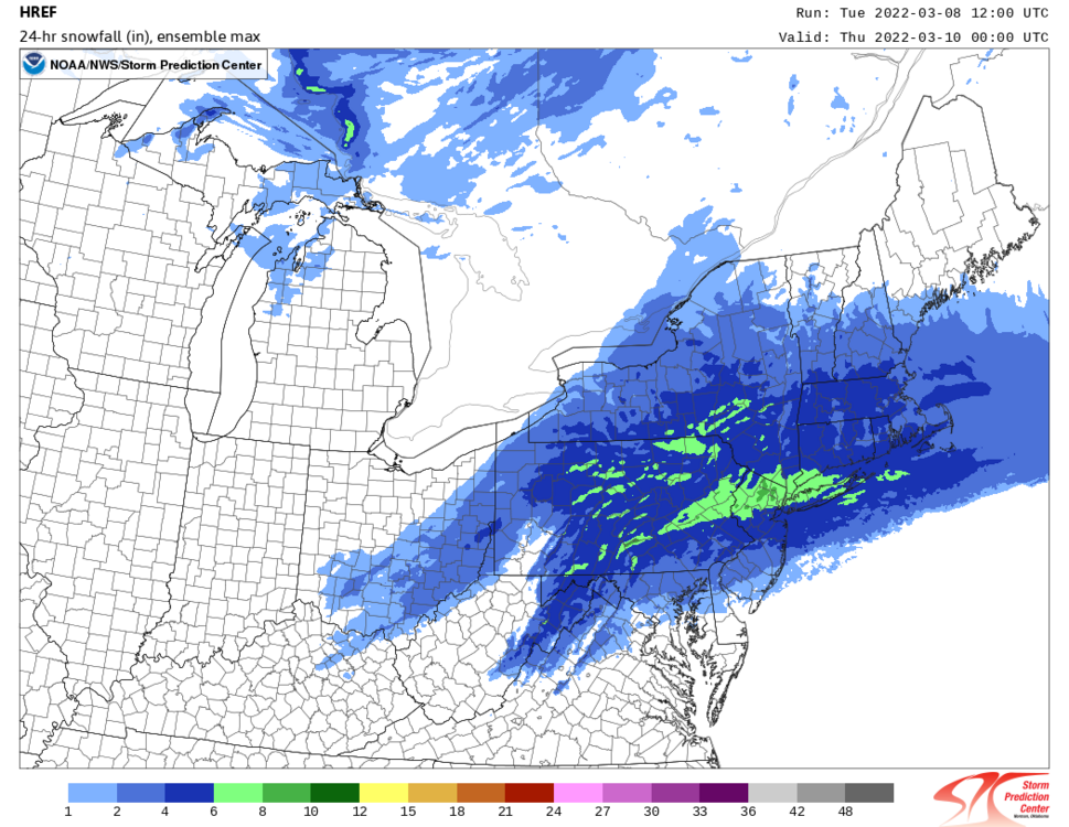
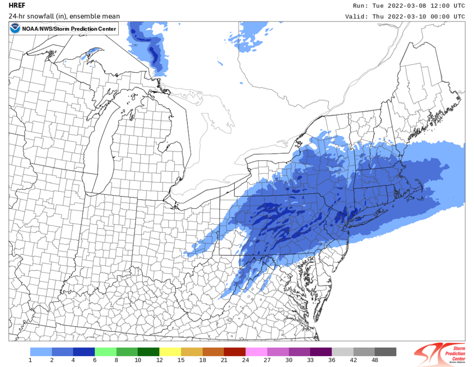
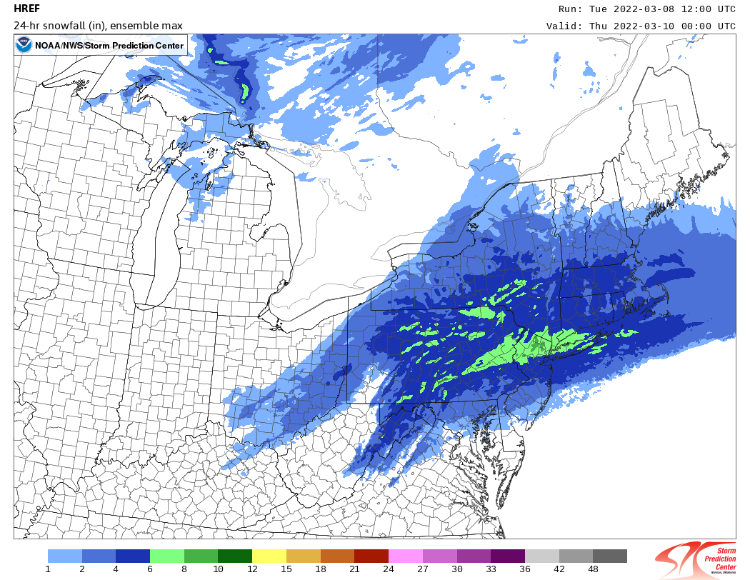
The SPC HREF has a mean of around 3 with spotty areas of 4 NE NJ/SW CT/Westchester with a max potential of 7-8. Its constantly been too high all winter though in marginal temp situations but it does indicate a potential for widespread amounts of 2 or so.