SnowGoose69
-
Posts
16,826 -
Joined
-
Last visited
Content Type
Profiles
Blogs
Forums
American Weather
Media Demo
Store
Gallery
Everything posted by SnowGoose69
-
It was a very east based -NAO if I remember right, the block was by Iceland
-
That was a coastal low with a closed low at 500...that is the only way you can ever see backend snows here with a coastal low, otherwise the system exits too fast and or the cold air does not come in fast enough
-
This event is somewhat similar to 12-11-93 but the main difference which will prevent the bigger snows from being near the coast is that you had a more notable neutral to negative tilt to that system. As a result you had a good 6-9 hour period of snows and your flow both at the surface and aloft was more NNE vs NW so there was no notable downslope impact.
-
The RGEM often times in scenarios where your CAA is coming on a NNW-N trajectory is way too slow bringing in the colder air...this event is atypical to many of the anafrontal snows we have seen in recent years where we got our cold air on a NW push...those always take forever and often models are too fast bringing them in. The difference in a 320 push vs 350 is night and day. The issue I still see though is 20-23Z I do not buy any meaningful snow in areas where downslope is a factor so basically most of the area except the NW...you'll see 17-19Z as the window for snow near the city and that is probably all with just flurries after...the 3km NAM idea post 19z I think due to the NW component is overdone
-
If temps are marginal it will be too high usually...it showed 2-3 mean across whole area last event which was obviously too much...it has 1-2 from NYC to the Suffolk border and 2-4 NYC west with some 4-5 inch areas Orange County and NW NJ
-
The RGEM really sucks in anafrontal type scenarios or where you have incoming cold air...it usually is way too slow bleeding it in...the changeover will probably be closer to what the NAM or HRRR shows but I still do not expect much snow near the metro once you have the gradient flow through 700 being most NW...the HRRR shows snow 20-23Z in NYC but reality is that would be flurries...the period from 17-19z when you're more NNE or N is when you'd see your snow. Any sort of NW flow in a rain-snow scenario here never pans out...you need to be N-NE
-
The RGEM/NAM are probably too far west if you ask me but I still do not like the setup anyway near the coast with the 3k nam or Euro setup
-
HRRR basically has the change line to EWR-NYC by 16Z so it seems to indicate its going to go with snow to the coast 18-22...overall the HRRR has been fairly good recently to my surprise at 24-48...it never was impressed near the metro with this last storm and was rainier than the NAM/RGEM at 18-24 hours out
-
Don't see how significant snow or really even low end meaningful snow happens at the coast in this one unless you get the track notably more east. You have too much of a NW component to the flow which will cause downsloping.
-
This is one of those strange cases where places which radiated at night are more snowy than places more urban that normally would be snowier in an e-se flow
-
10am-noon is the window to watch...could see mod snow in that time and where you probably get a quick 2 inches at the coast but it would then probably flip back to slop soon after
-
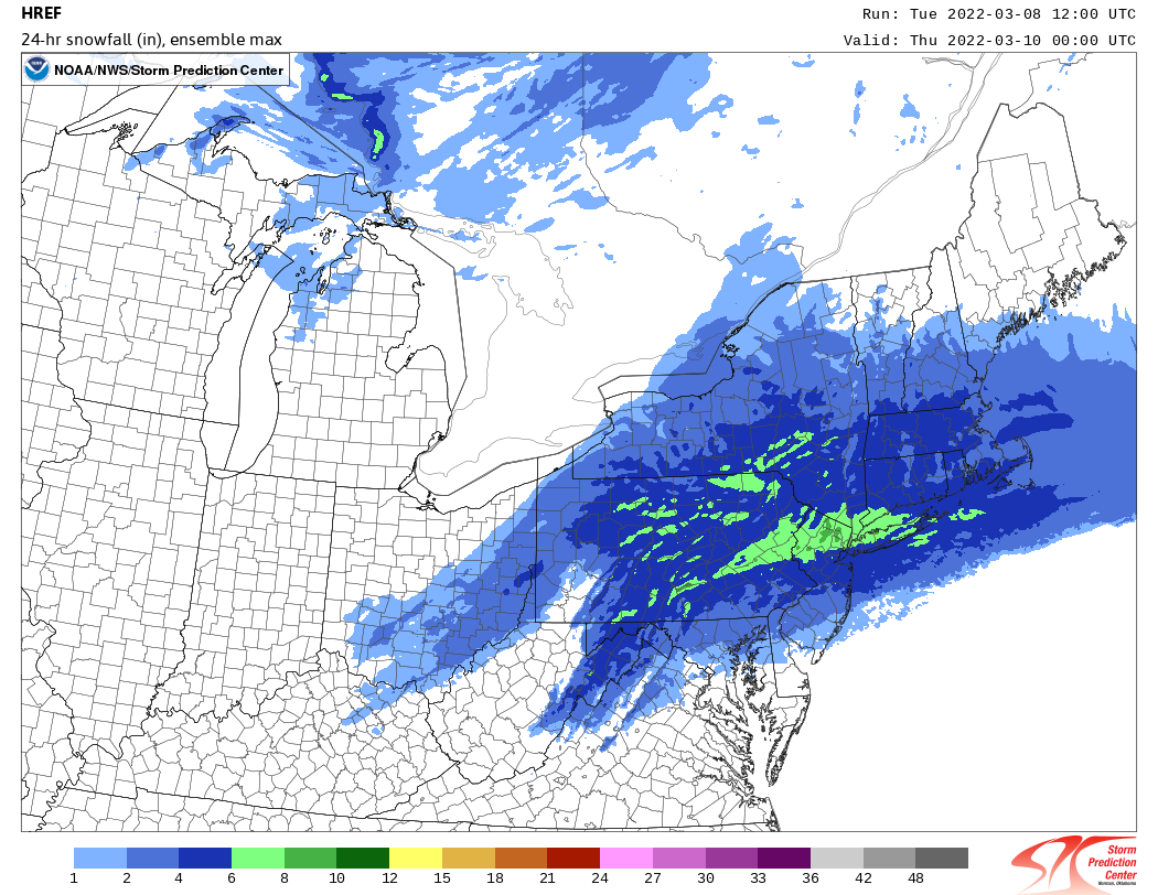
The SPC HREF has a mean of around 3 with spotty areas of 4 NE NJ/SW CT/Westchester with a max potential of 7-8. Its constantly been too high all winter though in marginal temp situations but it does indicate a potential for widespread amounts of 2 or so.
-
March 2022 Obs/Disc: In Like a Lamb, Out Like a Butterfly
SnowGoose69 replied to 40/70 Benchmark's topic in New England
Not the HRRR though! -
Well the HRRR sure looks good Wed 12-18Z if you want snow but as we know not trustworthy at this range
-
Euro is .27 snow at LGA but again taking those numbers verbatim is iffy..the Euro does indicate rates may be high enough but its also a whisker away from being amped enough its all rain
-
LGA 74 JFK 54
-
Ptype wise the 12Z RGEM makes more sense...it more indicates the coast is rain but if this ends up as dynamic as the 12z NAM/RGEM show it could be decent snows even at the coast...both show roughly 36/28 spreads when the snow moves in...thats more than enough if you have steady precip this time of year to pile up outside of the pavement
-
There is a notable snow min 3/15-3/30 then a second peak 4/1-4/10...I don't know if thats purely by chance as we are only talking about a period of 130 years or it may be a factor of continued shortening wavelengths leading to better chance a system is not able to wrap up and go inland or along the coast in April leading to better chance of a favorable snow track
-
It was Sunday night 10pm-6am Monday AM. I got 7.5 in Nassau. Most places saw 6-10 I think on LI with 3-6 in Queens/NYC though the airports due to it being 32-33 measured low. I think models simply could not resolve how well the lower level cold air would advect in...it was like 48-50 degrees at 6pm. I recall clearly the 4pm update Upton dropped the WSW which was out entirely.
-
For some strange reason NYC has climatological holes in snow from 1/1-1/6 and also 3/19-3/27 or so despite having big events before and after that..I'll never figure that one out, especially the early April max
-
Basically NNE winds everywhere...as is usually the case with these with a high in that spot models wanted to turn winds too ENE
-
LOL SWF reporting SN IP. I don’t think IP has been the code for sleet since the 80s
-
Yeah this still needs to be watched from LGA on W-N...there are still indications on all guidance of surface winds backing somewhat to 050-070 after 09-10z...and typically they underestimate the degree of backing when they show that and it ends up more 030-050..if that happens places like NE NJ/NYC/N Queens/Bronx are going to have problems
-
I think everyone in this subforum is 5 inches or less for sure with the 5 near SWF and 1 or less near NYC
-
The SPC SREF as far as snow amount mean is something between the NAM/RGEM in the LHV and S CT...for FRZ RAIN its fairly ominous for the metro and has notably high confidence across all of WRN LI W-SW into CNJ and the metro