csnavywx
-
Posts
5,730 -
Joined
-
Last visited
Content Type
Profiles
Blogs
Forums
American Weather
Media Demo
Store
Gallery
Everything posted by csnavywx
-
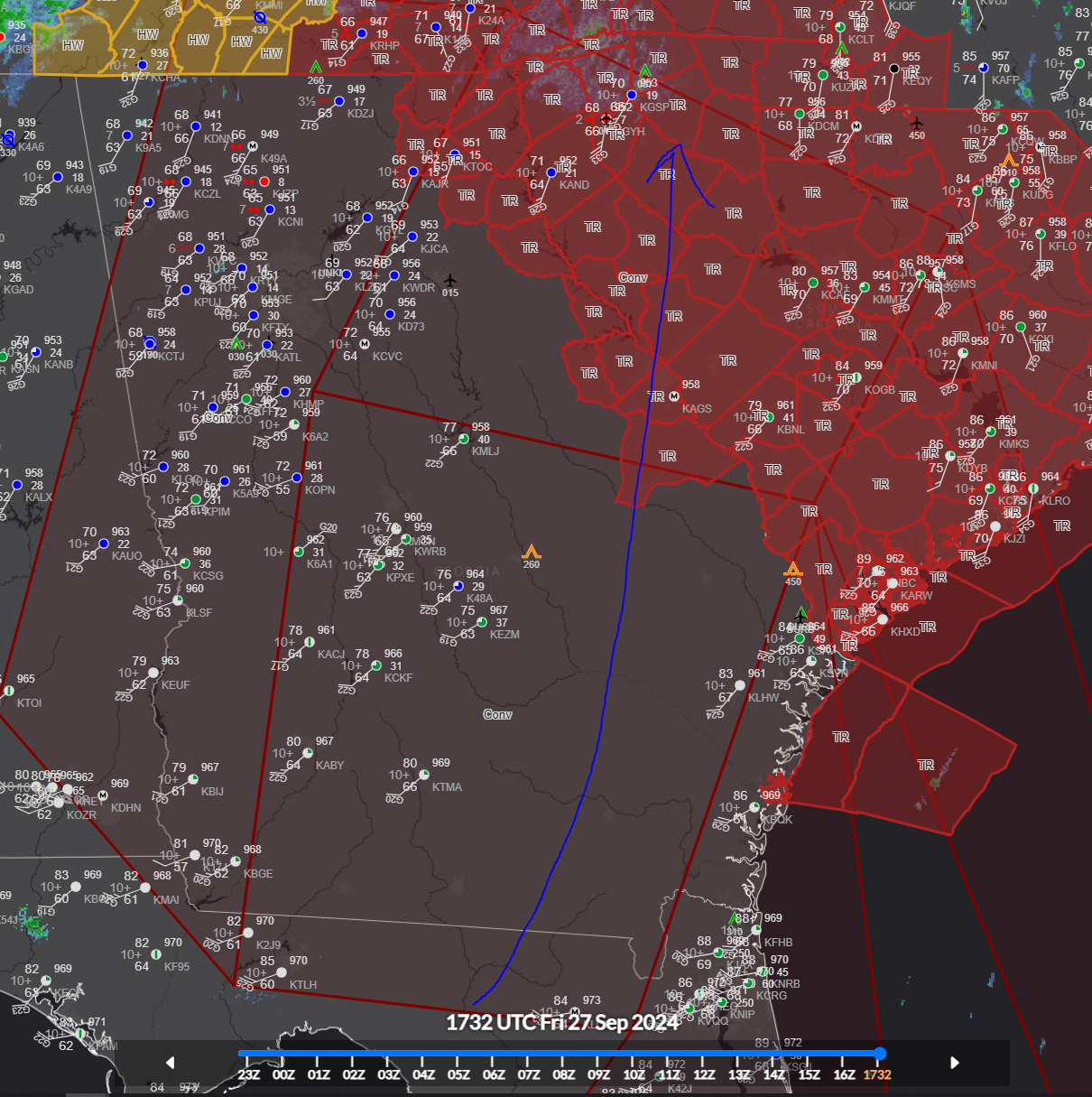
Really comes down to who is handling the H5/H7 features better here. GFS opens the upper low later than the EC and as a result has a more coherent WCB and warm nose, which ends up causing p-type issues but makes up for it somewhat with a stronger backside as the H5/7 vort maxes slide just south. The tracks and timing are otherwise basically the same. Either way, there should be some banding along/just left of the mid-level vort maxes.
-
I love these little systems. They tend to outperform. Quite a few lightning strikes now showing up on my display (14 in last 10m or so).
-
Temps ahead of the trough/front will be pretty mild (u30-l40s), but given the very cold temps aloft and the borderline convective setup right along the boundary, I would expect temps to drop pretty quickly as precip arrives. Convective overturning is in play here.
-
1/2" hail and plenty of lightning. Gusts to around 40mph. Very solid mid-winter thunderstorm. Probably the strongest cold season storm I've gotten since I've lived here.
-

Southern MD / Lower Eastern Shore weather discussion
csnavywx replied to AnEndlessMaze's topic in Mid Atlantic
Two legit chances here. First with the clipper-type system on Fri, which could produce a brief, but stout band or two and the front-end of Monday's system, provided the wave doesn't get sheared out too quickly or suppressed too much. -
Wouldn't sleep on this one. Nice trop fold, very weakly stable to moist neutral atmosphere as it moves in, strong digging mid-level (500mb) jet streak, and a favorable position of mid/upper features. Lack of decent low-level/surface reflection and a relatively dry boundary layer due to weak return flow are cons.
-
Land carbon sink stability (particularly in tropical rainforests and now in the Arctic) is now at serious risk: https://www.woodwellclimate.org/2024-arctic-report-card-tundra-net-source-carbon/ This comes as a significant jump in warming has occurred in the last ~10y. It seems increasingly likely that the existing stock of land plant and soil carbon just isn't stable at these temperatures. The one that worries me the most is South America and southern Africa as asymmetric NH warming causes the ITCZ to migrate northward. Respiration driven losses in those areas combined with outgassing and burning permafrost land (esp. peat) could conceptually eventually cancel out the global land carbon sink in general if it keeps going the way it is.
-
The fact that we're just going to gap straight up almost as much as we did last year (off of '16) is crazy. CERES imbalance has finally been reacting since spring and coming down off the dizzying heights of '23 though, so we *should* see some consolidation or retracement on the chart over the next few years. One would hope anyways. If the imbalance starts working its way back up without much temp retracement though, that's going to be a world of hurt.
-
St. Pete gusting to 100 on that last ob.
-
It's here: KSRQ 100136Z 32060G89KT 1 3/4SM +RA BR OVC008 23/22 A2860 RMK AO2 PK WND 33089/0134 RAE0059B06 P0012 T02280217 $ 102mph gust there. The 105KT FL winds recon found offshore a bit earlier in the southern quad were definite trouble, as was that telltale hook/stinger.
-
-
Yes, generally speaking, a shear vector aligned with the steering current is less detrimental, esp. in a case where you've got baroclinic forcing helping. It works up to a point. Michael had a good 20-25kt of shear for instance (if I'm recalling correctly). It won't stop 35+ knots of shear from being detrimental of course, but can effectively increase the threshold of viability.
-
It's going to be an interesting night of competing forces: increasingly favorable forcing from the entrance region of the subtropical jet vs. gradually increasing shear values.
-
My base case as well. It's got a window for another peak out there just past the Yucatan before shear starts to become an issue.
-
That method isn't really made for eyes that are 5 miles wide. GoM basin record in serious jeopardy. Been saying it since this morning elsewhere. Patricia, ERC or bust.
-
Outage maps are insane. Power outages all the way to the Ohio River valley. 200k outages in *Kentucky*
-
Lots of missing stations. Only the big ones leave a hole like this, in my experience.

-
Getting a lot of baroclinic help as it roars inland. Central pressure has been slow to rise relative to normal.
-
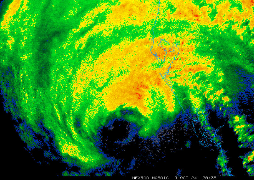
Still intense lightning activity in the western eyewall. Going to be a close shave for TLH.
-
Wavenumber 4 shape going on with the eyewall. Was probably there to an extent before but radar beam height getting low enough to pick up on it now.
-
Back down to closer to 250 strikes/3m. One of the most insane spikes of hurricane lightning eyewall activity I've seen though.
-
650. Peak? Last 10m have been insane. 2200 total.
-
Still spiking, 500+ strikes in last 3m.
-
I have >100 strikes a minute (426 strikes in last 3 min, 317 in 3-5m bin).
-
N/NW eyewall seems especially vicious. Clear overshooting tops on IR and lots of scalloping on reflectivity and on velocity products. Intense convection.