csnavywx
-
Posts
5,752 -
Joined
-
Last visited
Content Type
Profiles
Blogs
Forums
American Weather
Media Demo
Store
Gallery
Everything posted by csnavywx
-

2026-2027 Record-breaking El Nino
csnavywx replied to Stormchaserchuck1's topic in Weather Forecasting and Discussion
I agree Feb has the best chance of being cooler. Most of the caving is currently in the Jan window. I would expect something closer to what the BoM ensemble depicts. -
2026-2027 Record-breaking El Nino
csnavywx replied to Stormchaserchuck1's topic in Weather Forecasting and Discussion
The issue with using the CFSv2 at this time is that it is clearly having issues maintaining the initialized thermocline slope. That's definitely going to have an effect on its forcing placement and one of the reasons we see it giving ground. Feb will likely end up warmer. -
Big meh.
-
2026-2027 Record-breaking El Nino
csnavywx replied to Stormchaserchuck1's topic in Weather Forecasting and Discussion
No surprise the CFS is having problems here. It's been having issues maintaining the initialized thermocline slope for a while now -- hence the reason it continues to underforecast Nino 1+2. Some of that may be related to the model's native climo, and/or a bias towards reverting towards stronger easterlies. This is particularly important for a very strong, very east-based event. -
Day in and day out. Having a really hard time with holding onto elevated convection in setups like this. Decent instability gradient for them to ride down and shear improves this afternoon, so there's at least some chance this stuff makes it.
- 2,598 replies
-
- 1
-

-
- severe
- thunderstorms
- (and 7 more)
-
2026-2027 Record-breaking El Nino
csnavywx replied to Stormchaserchuck1's topic in Weather Forecasting and Discussion
The recurring interesting question for me has been how far east the warm pool will make it. Max SSTs are now sitting at 170-140W, which puts it neatly and completely inside the 3.4 region (and only a few degrees off of as far east as it ever got in '97). Further movement towards the east will increasingly put max SSTs inside Nino 3 at the "expense" of 3.4. If it gets to say, 130W or 120W, cooling will enter 3.4 from the *west* and it may end up stalling 3.4 while still spiking Nino 3. TLDR: This event may get so east-based as to break the measurement benchmark and cause it to systematically understate the event. -
2026-2027 Record-breaking El Nino
csnavywx replied to Stormchaserchuck1's topic in Weather Forecasting and Discussion
Subsurface moving back up in response. Surface should follow over the next several days. 1997-98 did not reach this level until mid-Oct. Any forecast that has us close to 82/83 or 97/98 at this point isn't really viable without a significant increase in trades *now*. -
2026-2027 Record-breaking El Nino
csnavywx replied to Stormchaserchuck1's topic in Weather Forecasting and Discussion
We've tapped the brakes here on the subsurface (peaking in the short run around +10-11C) as the trades temporarily recovered a bit, but the recent very strong WWB plus a migration of the standing wave towards 160W over the next ~10d should put the pedal back to the metal. CFSv2 forecasts are just playing catch-up on fully integrating the effects of wind stress and should bottom out here in the next week or so before crawling back up. -
No reason to think this train pauses before printing some 1.8-2.0 months.
-
2026-2027 Record-breaking El Nino
csnavywx replied to Stormchaserchuck1's topic in Weather Forecasting and Discussion
Might be sooner. In a separate interview the author said it may start earlier with the sub-polar gyre and we're already hugging the upper end of the equiv. warming rates in the paper. -
2026-2027 Record-breaking El Nino
csnavywx replied to Stormchaserchuck1's topic in Weather Forecasting and Discussion
That "snap back" effect may be more pronounced than currently imagined: https://www.nature.com/articles/s41558-026-02730-w -
2026-2027 Record-breaking El Nino
csnavywx replied to Stormchaserchuck1's topic in Weather Forecasting and Discussion
Ironically, if the increase in Nino variance extends to CP Ninos (as some CMIP6 models suggest may happen soon), then we may see enhanced CP episodes in addition to EP episodes, which ofc will be far more effective for cold winter patterns here. Add in PV disruption via a shoaling Atlantic water into the Arctic (setting up an increasing amount of ridging) and that may also constructively interfere. -
2026-2027 Record-breaking El Nino
csnavywx replied to Stormchaserchuck1's topic in Weather Forecasting and Discussion
I'll add on a bit here and say that the Arctic is much warmer now than in these events (especially post-2007). Quality of source region air is not going to be the same. If 1877-78 and the Great Nino of 1788-93 had trouble getting it to work, I'm not sure the baseline expectation here should be much different. The sample size here for these extreme Ninos is tiny ofc, so it is unlikely we have sampled the extent of the distribution but if these events (and the 1600s Nino) are any indication, we should probably not discount how fat the right (warm) tail is here.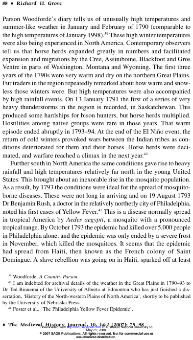
-
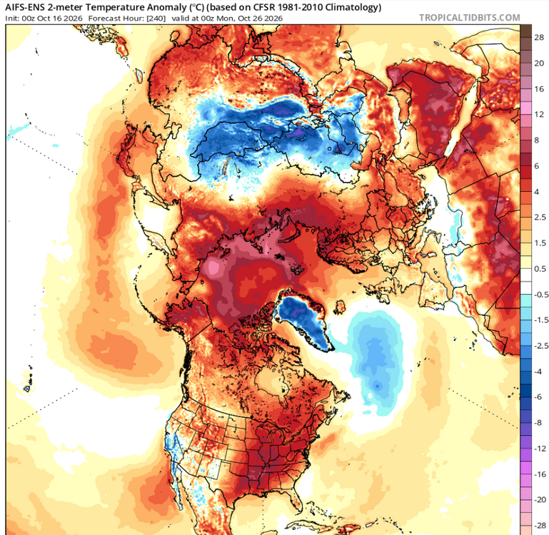
Someone needs to convince them to just start using the EC-AIFS alongside this. The initialization, bias and skill score improvements are too good not to.
-
This, ladies and gents, is what we call a dead cat bounce.
-
2026-2027 Record-breaking El Nino
csnavywx replied to Stormchaserchuck1's topic in Weather Forecasting and Discussion
Interesting article that would solve part of the kill mechanism of the P-T. Too difficult to compare today. We have a better continental configuration with more evolved ecosystems, a somewhat smaller basin and ice sheets+lower albedo to work with, but a sun that's 2-3% brighter. The buffer is obviously better, even if the "hothouse" ceiling has fallen a lot since then due to luminosity increases. -
2026-2027 Record-breaking El Nino
csnavywx replied to Stormchaserchuck1's topic in Weather Forecasting and Discussion
A review by GPT of the literature on 1k-10kyr (Holocene) ENSO: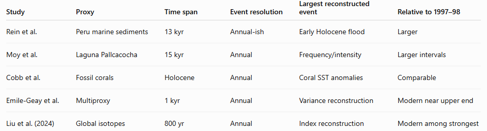
-
2026-2027 Record-breaking El Nino
csnavywx replied to Stormchaserchuck1's topic in Weather Forecasting and Discussion
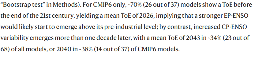
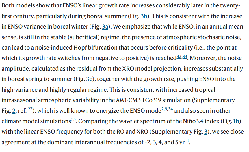
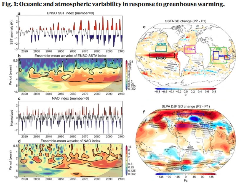
I've tried finding some ENSO reconstruction studies via proxies and can't find anything pointing to something this large. Still looking though. Prob safe to say 150y at this point. Might be realistically as long as 1kyr or something like that. A few recent papers have pointed towards increasing ENSO variance and amplitude with continued warming: Emergence of changing Central-Pacific and Eastern-Pacific El Niño-Southern Oscillation in a warming climate | Nature Communications (2022) And: Global climate mode resonance due to rapidly intensifying El Niño-Southern Oscillation | Nature Communications (2025) Strictly speaking, it is too early to say whether we are entering a phase of increased ENSO variability, much less resonance. The models here also use SSP5-85, which we are running under for emissions (but above for radiative forcing!). The takeaway, in my mind is to keep an open mind here about the *possibility* of a changing system. It's often common to see increased volatility as a state change approaches in non-linear systems like this (even if it's still decades away). The million dollar question, as @BlizzardWx points out, for this season is how far east the warm pool gets and how far east convection gets rooted into this winter. I think it may be as far east as 120W, given that we're already ahead of 1997 (which got to 140W). We're in such rarified air here, it's hard to tell.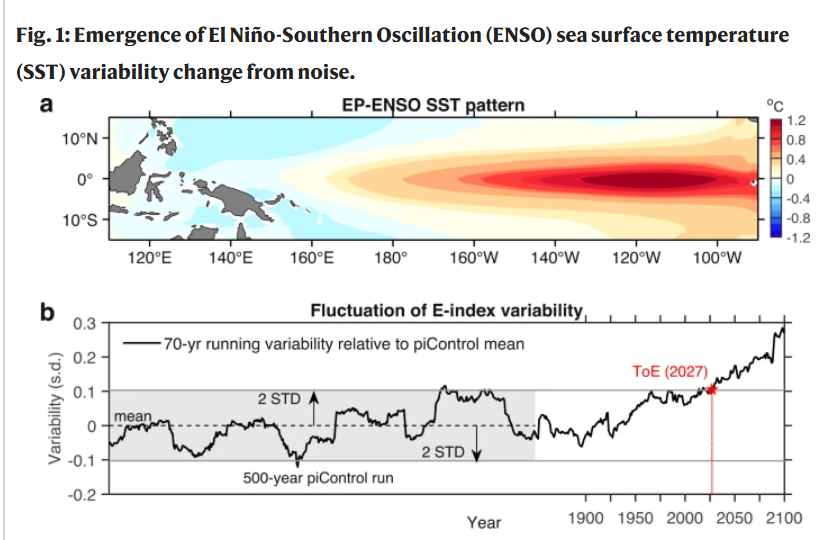
-
Carbon+nitrogen causing greening is good and it works until it doesn't. Burned area including ag stubble and grasslands instead of being broken out into category is also a problem. When you're changing ambient conditions by several degrees over the typical lifetime of a hardwood tree or conifer tree, we should not be surprised when that plant and soil carbon stock becomes unstable vs. realized temps. People generally think of wildfires as the primary component of correcting a landscape towards its equilibrium state and that's certainly an important mechanism (especially if we're doing peat or old growth forest burning), but if anything, the true surprise has been how total ecosystem respiration (TER) has changed in hot-wet environments and how big of a carbon source those regions are.
-
2026-2027 Record-breaking El Nino
csnavywx replied to Stormchaserchuck1's topic in Weather Forecasting and Discussion
Twitter feeds some of these folks to me too (I assume algorithmic engagement bait doing its thing), but yeah, agree that most of them are hobbyists. That said it's not totally hopeless if the forcing moves far enough east to sneak in some stuff late in the season. And we're kind of in a n=1 space if it comes to say, the warm pool making it to 120W (instead of 160-140W, heck it's *already* at 160). -
2026-2027 Record-breaking El Nino
csnavywx replied to Stormchaserchuck1's topic in Weather Forecasting and Discussion
Pretty obvious it wasn't going to be a Modoki from early on given the unusual off-equator WWBs and strength of the subsequent WWBs near the equator. It was catchable by late March-early April and dead easy call to make by late May. -
2026-2027 Record-breaking El Nino
csnavywx replied to Stormchaserchuck1's topic in Weather Forecasting and Discussion
This is a known issue with the model. It will almost always favor CP Ninos until later on. I'm going to guess this has at least partially has to do with too much ocean model vertical mixing and diffusion as well as convective schemes that underestimate coupling and convective feedbacks (e.g. Bjerknes feedback). -
The newer CMIP6 models place more importance on winter temps and the Atlantic front going forward. This year is a good example of that. Pretty good conditions present on the Pacific front, but the Atlantic front is weak enough to place the CAB near record lows with continental heat placing the CAA near record lows too. I keep expecting us to hit a wall here on extent (and we probably still will). However we may also get a decent late season run since there's still quite a bit of ice left to melt at lower latitudes in the Pacific. Regardless, I would not expect anything flashy until later next season or during the fall refreeze in '27. That's when big +ENSO tends to have an outsized effect.
-
2026-2027 Record-breaking El Nino
csnavywx replied to Stormchaserchuck1's topic in Weather Forecasting and Discussion
Record warm water volume this time: -
2026-2027 Record-breaking El Nino
csnavywx replied to Stormchaserchuck1's topic in Weather Forecasting and Discussion
Yes. The keystone paper you're looking for is here: Influence of the state of the Indian Ocean Dipole on the following year’s El Niño | Nature Geoscience Made a note of it last year, but at that point it looked initially like a moderate event was most likely. wxchris on X: "The recent record/near record -IOD is collapsing. Warm water is sloshing east towards the WPac, putting the fully mature Nina on borrowed time. Expect whiplash. https://t.co/rZb3PjimBU" / X