csnavywx
-
Posts
5,722 -
Joined
-
Last visited
Content Type
Profiles
Blogs
Forums
American Weather
Media Demo
Store
Gallery
Everything posted by csnavywx
-
 Virtually all of the LSRs are confined up on the Piedmont and mountains to the west/southwest. Makes sense, because that was the only area that got a chance to destabilize a bit before the crapvection-driven overturning got going. Consolation prize is that it's killing the line off completely to the south, so there might be a chance for the cold front this evening to have a bit of something to work with.
 -
Needs a lot more helicity with this low amount of buoyancy. There's a narrow window this evening before the cold front, but you'd have to stop bombarding the warm sector with this low grade overturning for it to work. This is why capping is so important. You have it or you get this nonsense.
- 1,093 replies
-
- 1
-

-
- severe
- thunderstorms
- (and 1 more)
-
Glad I've been downplaying it to all of my customers today. Quite the bust on the way. Hell I might have not downplayed it enough. Sure, there will be some more 50KT reports and a tor or three but I anticipate this probable bust is going to cause some issues later in the season when we do actually get a system with a clean warm sector. And that's pretty likely, imo, given the strong ramp into Nino.
- 1,093 replies
-
- 9
-

-
-

-

-
- severe
- thunderstorms
- (and 1 more)
-
Little peeks of sunshine here. But too much crappy low grade convection polluting the warm sector now, especially in the east. Some is okay ofc, because ideally you don't want your LCLs too high, but still need a corridor of at least some halfway decent destabilization ahead of this afternoon's activity.
-
LevelTen warns of rising PPA prices amid US trade, policy strain – pv magazine International This is even more up to date. Tariffs are mentioned and I'm sure those aren't helping, but the trend was there prior to that. And it does not include the global run up in almost all base materials over the last 1-2yr. There's a lot more supply that needs to be unlocked, but that requires sustained higher prices. This was mostly dismissed for years as there was "plenty enough global reserves to go around and the market would take care of it". Well the market is going to take care of it alright. By taking it right out of your pocket.
-
Yes, too much talk about tail risk of nuclear and a chronic downplay of ECS >4C scenarios up until very very recently.
-
I mean, you made the point for me here. If we had hedged off w/nuclear (on a scientific, rational basis) we'd be in a much better spot today. But fear won and so did the campaign to offload responsibility onto the individual (e.g. "carbon footprint", "carbon offset" nonsense) and away from capital interests. Label the individual as the "junkie" (Purdue Pharma style, just nicer words) while perpetrating fraud. Sell the fix as cheap and easy and ultimately again, as up to the individual. Ignore the obvious ideological holes. And by god, never ever talk honestly about the tail risk. It was and continues to be a systemic, collective action and thermodynamic problem.
-
RE will continue to get more expensive on a PPA basis so long as we continue to ignore the issues plaguing transmission, distribution and direct competition between industrial scale AI/DC buildout and the insane lack of investment in upstream base materials supply (like spinning up mining and refining). I maintain that negative prices on the spot market are a sign of market failure, not something that should be cheered. These prices certainly are not going to get better this year: The correct take is that *all energy* will continue to get more expensive in the world we've built for ourselves now. (Disclosure that I am long ICLN -- because yes, most of these companies will try and expand their margins off the backs of the ratepayer and externalizing the grid cost -- my PNL tells me if I'm right or not, so far, so good.)
-
Southern MD / Lower Eastern Shore weather discussion
csnavywx replied to AnEndlessMaze's topic in Mid Atlantic
About a solid inch of paste with this system after a record high print yesterday (84 vs. 80 old record). Nice little last hurrah. Probably had the best rates of the winter for about an hour there. -
We win when we hedge the risk properly. The phenomenon you're describing is literally us discarding that tendency to hedge out the window, right as volatility ramps. Yeah, policy prescription has sucked to this point and the shilling about the "low cost of transition" has turned out to be damaging and wrong (if you have doubts, look at PPA prices and virtually every base metal in the past couple of years) It was always going to be costly (a significant % of GDP). The balking at the cost is understandable and the damage costs *to this point* have been mostly a "freebie" since it's a) mostly indirect, b) have not pushed us outside historical ranges except at/very near the equator, c) non-linear change tends to be slow at first, and d) tech/econ growth rate has been enough to offset. Problem is, if you wait until forward economic growth is meaningfully impacted, much slowing towards zero, then you are already too late. Hedging 20 years ago would've been much cheaper. Hedging now is fairly expensive. Hedging 20 years from now will be extraordinarily expensive. You hedge when it's cheap, not when you have to. But until we do hedge this risk properly and start really taking it seriously, the doomers will be right. You are literally short selling a temp graph that is accelerating up.
-
Southern MD / Lower Eastern Shore weather discussion
csnavywx replied to AnEndlessMaze's topic in Mid Atlantic
Big ol' parachutes coming down here with this little WAA driven event. Enjoying them while they last! -
Copernicus Marine showed a 76 (!) ZJ jump in OHC in '25. It's a much more volatile data series than the others, but even the smoothed IAP, etc showed ~24ZJ. Just for reference, if you plug 76 ZJ into the top 400m of the global ocean, you get +0.13C. That's oversimplified ofc, but gives you an idea of just how much heat we're dumping into the ocean. IAP's ~24ZJ gives you 0.14C if isolated to the mixing layer +1 y of extension via diffusion. And the implied EEI from that is about +1.5 W/m2. So these temp increases we're seeing at least seem plausible. We'd better hope these rates slow down, because we're talking pretty extreme rates of ocean surface warming which ofc will translate to even higher land surface temp rates. The fact that we can print a 1.44 W/m2 figure at these already very high temps is giving me some serious pause.
-
CERES monthlies have rebounded strongly this year. Much higher than I would have expected. Matches the notable leap in OHC figures. I was thinking this year's potential Nino would have a lesser impact on temperatures, but I am not as sure now: (from Leon Simons on X)
-
Southern MD / Lower Eastern Shore weather discussion
csnavywx replied to AnEndlessMaze's topic in Mid Atlantic
Back to snow grains/pellets. Having issues keeping the snow growth zone saturated it seems. -
Southern MD / Lower Eastern Shore weather discussion
csnavywx replied to AnEndlessMaze's topic in Mid Atlantic
Prob won't see much til about 6pm. Low is still >1000mb. Dropping fast now, but wind lags the increase in pressure gradient force. -
Southern MD / Lower Eastern Shore weather discussion
csnavywx replied to AnEndlessMaze's topic in Mid Atlantic
Getting some snow grains mixing in here. Usually means cloud tops are not quite cold enough. Needs more time. -
Southern MD / Lower Eastern Shore weather discussion
csnavywx replied to AnEndlessMaze's topic in Mid Atlantic
Better diabatic cooling from getting decent precip early on and strong low-to-mid level lift doing its job. Winds flipping north earlier than forecast didn't hurt either. -
Southern MD / Lower Eastern Shore weather discussion
csnavywx replied to AnEndlessMaze's topic in Mid Atlantic
All snow here. About 3 hours ahead of schedule. Usually a decent sign. -
Southern MD / Lower Eastern Shore weather discussion
csnavywx replied to AnEndlessMaze's topic in Mid Atlantic
For you, should be cranking into the overnight. Will be occasional breaks/lulls as the precip starts taking on a more convective nature and you do lose some saturation in the DGZ as the low pulls in super close to shore -- but there could be a few rumbles of thunder later this afternoon and evening too. -
Southern MD / Lower Eastern Shore weather discussion
csnavywx replied to AnEndlessMaze's topic in Mid Atlantic
Flipping from light rain to light snow here already. -
Southern MD / Lower Eastern Shore weather discussion
csnavywx replied to AnEndlessMaze's topic in Mid Atlantic
That's early! Good news there. -
If you're near or within ~50km to the left/west of the developing 700mb front, BL and ground temps are just not going to be an issue. 2"/hr doesn't care.
-
Southern MD / Lower Eastern Shore weather discussion
csnavywx replied to AnEndlessMaze's topic in Mid Atlantic
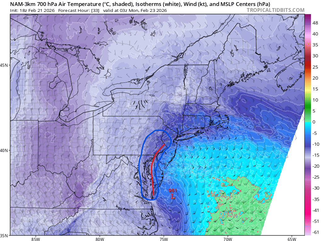
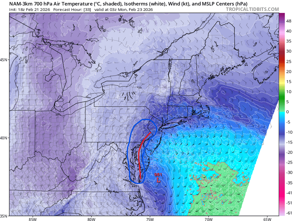
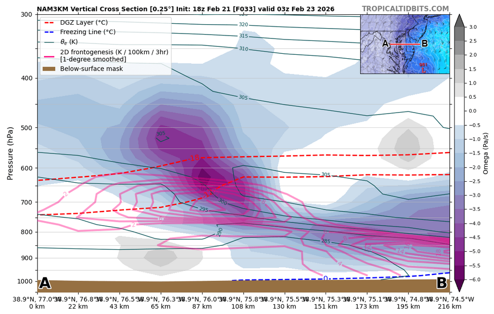
That 18Z NAM run is an all-timer. Bonus is that it's 18-24hr out. Gonna be cranking up the BUFKIT profiles for this one and posting em for everyone here when it posts to PSU. -
Southern MD / Lower Eastern Shore weather discussion
csnavywx replied to AnEndlessMaze's topic in Mid Atlantic
We gotta pump that post:snow ratio back up in here. -
Southern MD / Lower Eastern Shore weather discussion
csnavywx replied to AnEndlessMaze's topic in Mid Atlantic
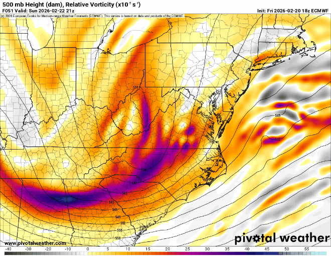
Better/earlier phase and better tilt with the new Euro. Note how the 500mb low closes off earlier. Delmarva nuke time: