csnavywx
-
Posts
5,722 -
Joined
-
Last visited
Content Type
Profiles
Blogs
Forums
American Weather
Media Demo
Store
Gallery
Everything posted by csnavywx
-

2023 Atlantic Hurricane season
csnavywx replied to Stormchaserchuck1's topic in Tropical Headquarters
For sure -- we're getting close to put-up-or-shut-up time. My lean this year has been at or below average. But it's the type of year where even one or two decent setups can yield some seriously convex risk. -
2023 Atlantic Hurricane season
csnavywx replied to Stormchaserchuck1's topic in Tropical Headquarters
Genuinely hoping none of those pan out. The last thing we need is a TC making into the furnace that is current Gulf/Carrib. SSTs/OHC with low shear this year: -
So far, this has been a *very different* evolution than we're used to for a Nino. It's done just fine surviving off of weak OKWs breaking near SA instead of further up the coast and tapping the NE Pac warm pool instead. Once the monsoon ends, we'll probably see the forcing being cited migrate east. The warm pool has already migrated to just west of the dateline and some significant TC-induced cooling has occurred near/north of the Maritime continent. I get the idea that we need strong WWBs and that's the classical analog take, but this one seems hellbent on using a route we haven't seen since the pre-satellite era. If I were a snowbird at this point, I'd be rooting for a HHTH forcing-induced blocking over western NA and to help nudge the BoA low a bit further west of its standard Nino position or just amp the western ridge. Then maybe the supercharged STJ doesn't completely screw over the synoptic setup by flooding the CONUS with Pacific air. Def seems like an easier lift than trying to bank on it heading to a more C-Pac based nino.
-
Might be relevant: https://journals.ametsoc.org/view/journals/clim/28/22/jcli-d-15-0006.1.xml Paper's a bit dated now but conclusion still holds. Stronger drying from subsidence probably not helping. And whaddya know: Now, I'm sure there was some component of drying from mass deposition from the TC (as Andy points out in the comments), but it was very dry regardless. Most publications will probably cite the stuff we hear all the time (increased SSTs, etc), but being as SSTs are regionally cooler than normal, that wasn't much of a factor here. Gonna say the downsloping helping mix down super dry air aloft was it.
-
Yep, that's the kicker. The secondary knock-on effects in this case might end up being greater than a simplistic radiative forcing calculation would suggest. And the regional signal for an ensemble is surprisingly large. Large enough that it's a consideration when putting together seasonal forecasts for the next few years. Might -- for instance -- nudge the typical Nino winter/spring pattern of a BoA low further west a bit, blow out snow cover early and chain to more Greenland ridging in the summer. That scenario would certainly match a warmer Arctic and regionally cooler mid-lats and wouldn't shock me if a number of the ensemble members are sniffing out just such a teleconnection. Also, ooof for West Coast rainfall and snowpack if that's correct.
-
2023 Mid-Atlantic Severe Wx Thread (General Discussion)
csnavywx replied to Kmlwx's topic in Mid Atlantic
Just got hit by that tail-end charlie cell. Strobing lightning. A few small hailstones but looks like the core thankfully went just south of the house. -
2023 Mid-Atlantic Severe Wx Thread (General Discussion)
csnavywx replied to Kmlwx's topic in Mid Atlantic
Tail-end charlie storm just SW of Fredricksburg looking pretty beastly after that merger.- 2,785 replies
-
- 2
-

-
- severe
- thunderstorms
- (and 3 more)
-
2023 Mid-Atlantic Severe Wx Thread (General Discussion)
csnavywx replied to Kmlwx's topic in Mid Atlantic
Yeah, that main bow probably going to steal the show and at the same time close off the (currently) most favorable area for supercells. Cells further south that can remain more discrete will have their shot as they get closer to the Bay.- 2,785 replies
-
- 1
-
-
- severe
- thunderstorms
- (and 3 more)
-
2023 Mid-Atlantic Severe Wx Thread (General Discussion)
csnavywx replied to Kmlwx's topic in Mid Atlantic
Almost pristine airmass downstream off the Blue Ridge. Weak capping and 45-50kt of eff. shear. 30-33K delta theta-e between mixed layer and mid-levels. My typical cutoff for severe is 25K, but can be lower with this kind of shear. The faster that cold pool develops and deepens, stronger it will get.- 2,785 replies
-
- 7
-
-
- severe
- thunderstorms
- (and 3 more)
-
Report: Another Year of Record Heat for the Oceans
csnavywx replied to donsutherland1's topic in Climate Change
I wish you the best, but he isn't here to actually learn squat. He's here to post bullshit social media memes like they're science fact. The literal inverse of his username. -
Citation definitely needed for this statement. Preferably anything peer-reviewed. Conversely, where are all the deniers from '13-'15 that were crowing about record highs then? Crickets now. That's the kind of behavior that you'd expect from people that have zero conviction about their theory. They vanish or move the goalposts when the short-term data goes against them. The constructive interference of internal variablity + wind stress changes + tropical forcing was always going to flip the other way at some point and if you knew what you were talking about, had conviction with the data to back it up and were willing to eat some humble pie in the short run, the prediction was always going to pan out in the longer-term.
-
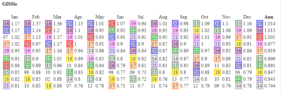
Actually, looking at GISS records vs moyhu's current temp change from June to July, the gap up for July annual could be similar or even slightly larger than the distance between (current) 1st place and 10th. Remarkable.
-
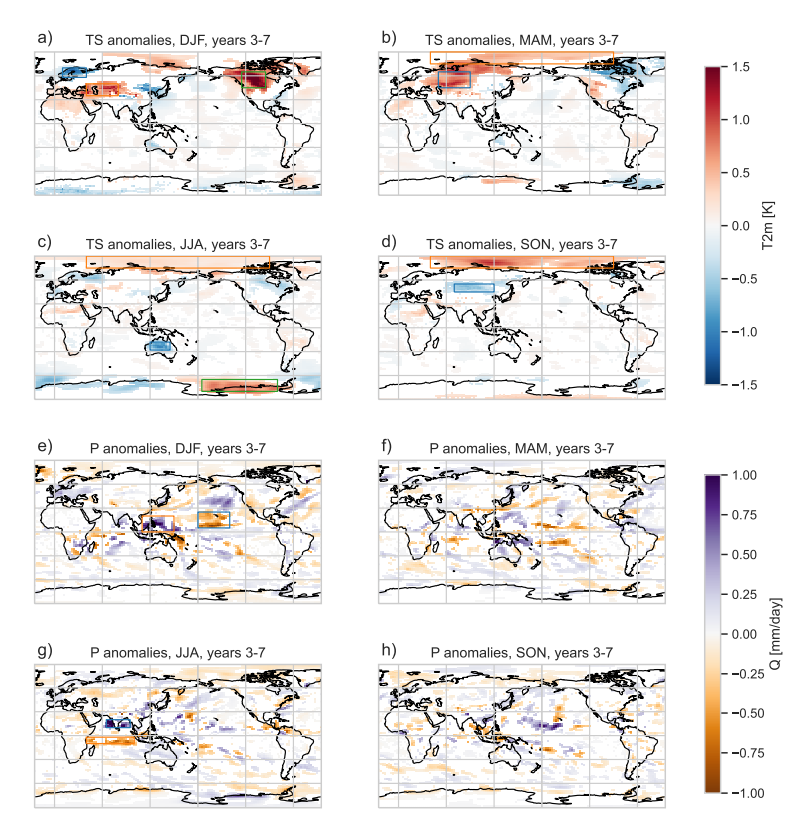
The gap-up coming for July is pretty surreal, esp. considering that ENSO effects are usually still seasonally muted at this point (image courtesy of moyhu):
-
The "price" is higher dewpoints. CO2 drawdown isn't really a thing beyond the delta you'd get by increasing planting density, which is already very high. Converting it all back to forest would work to a degree, but we aren't going to do that.
-
Nope. Well documented increase in mixing ratios/dews to go along with that trend. It's a transient response almost by default since planting density is already very high and most of the land that can be farmed already is. Crank it a few more degrees and you set up a pretty vicious snap-back temp response once crops start having heat issues and the ET response is weakened.
-
Yep, and that's the problem. We don't know what the distribution necessarily looks like now and since the transient climate response is so rapid by the time you get enough data, it's already moved on. Needless to say, paleoclimate doesn't have many nice things to say about where we're headed. This sort of "climate flickering" happened in periods of rapid change in the past as well.
-
Yep, lived there for a while. Wouldn't wish that malaise on anyone and a few hours of exposure can kill you. 40 minutes of that nearly put me in heat exhaustion once. Most outdoor work is done at night as a result. And - essentially -- they are reliant on air conditioning at times. One of my favorite tells to see if it was safe to go out during the bad times of the year (Jul-Sep) was to look out my window and see if any locals were walking around in traditional garb. If not, I stayed put. They're adapted for it -- so the shit won't really hit the fan on this angle until we start seeing these kinds of conditions spread beyond the usual spots.
-
Weak OKWs breaking along the equatorial coast instead of more poleward certainly helping, as was the contribution from the EPac warm pool. Probably a mode that was more typical pre-satellite era, but we were used to the big WPac driven events. Perils of sample size, I suppose.
-
Good thing is that we're going to be able to test this prediction pretty soon. Agree that this year was like a coiled spring from a global temp standpoint. Key will be to see where that spring manages to jump to.
-
We're not yet to the point where we need to worry with WBTs. You need T/Tds of 100/85 or 115/80 type temps to hit dangerous levels (>31C WBTs) and 115/90 or thereabouts for true, hard habitability limits. 100/85 seems reachable in a few select areas for brief times, but Tds of near 90 don't seem possible yet.
-
Yeah, after this little batch of activity, I'd definitely be looking upstream to the outflow-reinforced front. Should be a really nice instability gradient and source of low level convergence for another MCS to come ripping east again tomorrow.
-
That rear inflow jet -- sheesh. Looks to be outrunning the reservoir of readily available instability though. Only the southern fringe is likely to survive into the evening hours. Given the strength of the RIJ, cold pool and advection aloft, might see some induced isentropic lift atop the "dome" and get some additional elevated thunderstorm activity to fire in its wake.
-
2023 Mid-Atlantic Severe Wx Thread (General Discussion)
csnavywx replied to Kmlwx's topic in Mid Atlantic
Meh, mostly a bust for our area. Cells struggled as they came off high terrain over N Va and most of MD. Needed a bit more BL moisture to avoid it being partially mixed out in the PM hours. Where that was available, they did pretty well. Ironically, we'll probably get better storm coverage today with higher quality BL moisture and direct forcing from the upper trough. Shear is light, so shorter-lived multicells only.- 2,785 replies
-
- 3
-
-
- severe
- thunderstorms
- (and 3 more)
-
2023 Mid-Atlantic Severe Wx Thread (General Discussion)
csnavywx replied to Kmlwx's topic in Mid Atlantic
Deeper mixing is indeed a failure mode here but the HRRR is probably overdoing it, esp if there is any debris in the morning from overnight activity.- 2,785 replies
-
- 1
-

-
- severe
- thunderstorms
- (and 3 more)
-
2023 Mid-Atlantic Severe Wx Thread (General Discussion)
csnavywx replied to Kmlwx's topic in Mid Atlantic
Yep. My favorite theta-e delta method (diff of average boundary layer theta-e and average minimum mid-level theta-e) is sitting around 30-35 deg. K on the 3km NAM. My typical threshold for summer severe is 25 or slightly less on global models along with 35-40kt of wind somewhere in the 700-500mb layer to provide adequate shear. In this case, we've got that and some directional shear. I'm still a bit wary convective debris from overnight activity here but if there's no big organized, long lived MCS upstream, then what cloudiness there is might actually help tamp down BL mixing a bit in the late morning hours. Leaning towards ENH being necessary here without major changes.- 2,785 replies
-
- 8
-
-
- severe
- thunderstorms
- (and 3 more)