csnavywx
-
Posts
5,720 -
Joined
-
Last visited
Content Type
Profiles
Blogs
Forums
American Weather
Media Demo
Store
Gallery
Everything posted by csnavywx
-
Yes, thank you. Corrected it.
-
The sun was 0.6-0.7% dimmer 65 million years ago. You don't need as much CO2 for a given temperature this time around. Antarctica glaciated around 650ppm, but my guess is that due to solar luminosity increases, you'd only need around 550-600 to deglaciate it this time around. Humans do not appreciate just how late in the game we showed up and how lucky we are for CO2 to be as (relatively) low as it is now. Another 200-300m years and this planet is going to be a permanent hothouse. Edit: To correct "brighter" to "dimmer" as intended.
-
Sweet. Best of luck to ya and send us pics, man!
-
I think I'd avoid IL altogether at this point. 250mb jet position and shared energy area is a dead ringer for getting washed out by thicker jet cirrus. Guidance has just started picking up on it and now dprog/dt is starting to trend the wrong way. That shit will come in fast and you won't have time to reposition adequately. It'll look fine in the morning and by lunch, you'll be screwed.
-
Honestly, I'm afraid it's largely going to be a shitshow. There will be a few places that don't have any problems, but this is par for the course for April climo. The best one was always probably going to be Aug '17, though. The areas that *look* like the best (near STL/Carbondale) probably won't be because of thicker jet cirrus moving in at the last minute (that isn't being well forecast) and the little room you get to maneuver in IN/OH inside the dry slot will be crowded as fuck because everywhere else isn't great. Get too far east in OH and you're dealing with stratocu. Try to avoid it altogether and head to ME and you're running into a massive fresh (but melting) snowpack and less than stellar road network, and crowded too as most of the cities down south empty out to head there.
-
Cold core spring upper lows are the best. Need very little lift and instability to get them to work their magic and they usually produce strong winds and small hail with ease.
-
Reinforcing this conversation wrt Ortiz-Bobea et. al with this new paper, which attempts to quantify CC's effect on food inflation. https://www.nature.com/articles/s43247-023-01173-x#:~:text=Evaluating these results under temperature,amplify by 30-50%. TLDR, it's a lot. Enough that we should expect to see what's happening to cocoa in more commodities (sharp squeezes and dumps that don't quite correct back to the original level over the longer run). Inflation volatility also increases. Does not bode well for either food or fixed incomes that rely on government bonds. A persistent 50-150bp of headline inflation will cause a significant devaluation across the board and also hamper any equity price runs via bond volatility spikes.
-
Freezing levels are so low, it doesn't take much convective depth in this case to get lightning and small hail, given where the cloud bases are.
-
Feelin pretttttty good about this one from yesterday:

-
I think we all know who's sock that is by now and it's because they don't think the data is real. When a good scientist gets new data, they change their opinion. When most people get new data, they change the data.
-
Solar and EV equity prices continue to be smashed, with the TAN ETF down 16% so far this year and 43% y/o/y. Even the best positioned companies are suffering pretty heavy balance sheet hits due to higher rates and higher capex costs, despite hardware component price declines. Domestic EV makers are being hit in particular due to slumping demand and are sensitive to higher financing costs. Unless those margins can be improved, R&D and capex will start taking a hit and these deployment rates are going to suffer as a result. Like I mentioned before, costs are important, but we live in a capitalist system -- profit margins are even more important! I was hoping we'd get some interest rate cuts this year, but the market is starting to price those back out as core inflation remains too sticky/resilient.
-
Remember 10 years ago, when every denier was crowing about "flat temps since '98", increasing Antarctic sea ice and an impending "grand solar minimum"? Imagine saying that, then looking at this graph and *still* wanting to short sell it.
-
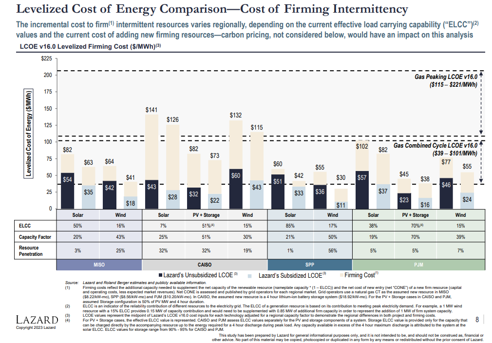
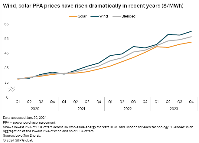
The IRA was definitely a much-needed stick save. Agree there. It could be worse. We could be Europe or the UK! They're now mired with sticky inflation, flat to negative growth and cratered PMIs persistently sitting in the 40s. We have largely escaped that (though we still have some sticky inflation which will keep rates elevated for at least a while longer). Hell, Europe had *negative* risk-free rates for a while. That was a trip. And incidentally, a goldilocks environment to do renewable investment. That quickly unwound with the pandemic and then the war. I'd prefer to see large baseload nukes preserved and expanded where possible and income-based supports for where firming costs are getting high (cough, CAISO, cough). Fee-and-dividend type system would go a long way, too. Chart is somewhat informative (it's not perfect, but it is what it is). We definitely don't want to fall into the trap that Europe has fallen into as that comes with all kinds of embedded geopolitical risk. (North American PPAs only -- the bottom was in '19/'20, this takes it back to 2017 or so pricing.) Src: https://www.spglobal.com/marketintelligence/en/news-insights/latest-news-headlines/north-american-solar-wind-power-prices-continued-ascent-in-2023-report-80219261

-
I'm less sanguine on this than others due to a complete lack of consideration for profits, power density, grid infrastructure or firming costs in virtually all of the analyses. Cost of raw hardware components and the initial margins are always talked about, because they're favorable. In reality, they end up being quite cheap *at first*, but quickly run into firming cost issues as soon as saturation increases. Regardless of whether you like it or not (I sure fuckin don't), we're trying to transition in an almost completely market-based manner and the market is overwhelmingly concerned about returns. Ask GE or Siemens how that's going for them recently with cratering profit margins. Hell, with battery farms, most of the returns at this point aren't even in what you would expect -- power arbitrage. It's in ancillary services! Returns in general were a lot easier in a low inflation, zero-interest-rate environment. Zero consideration is also given to rebound effects. Slow decarbonisation is a trap, as the incremental additional capacity will get used up on growth. Efficiency savings will be spent elsewhere and typically result in *more growth*. You need decarbonisation in large chunks.
-
79 here today. Daffodils loving it. Started coming up on the 23rd.
-
Nobody cares since you won't provide falsification criteria for your theory.
-
I'm still lending some credence to the shipping aerosol hypothesis mostly because they called the warming *before* it happened and it showed up pretty much exactly where and when you would expect it (N Pac, N Atl maximized in late summer). Of course, it's not the only thing going on and it will take some time to disentangle all the factors, but definitely not ready to drop it as a contributing factor. (The IMO phase out was in 2 stages, a smaller one in 2015/16 and the second bigger drop in 2020).
-
Snow shower activity showing up to the west as strong CAA aloft pushes in and drops the top of the boundary layer <-10C. Should see some pretty decent snow shower activity this evening after the main synoptic snow dies off.
-

Jan/Early Feb Medium/Long Range Discussion Part 3
csnavywx replied to WinterWxLuvr's topic in Mid Atlantic
Nino climo for the mid-Atlantic has pretty pronounced peaks in mid-Jan and mid-Feb. Following the script so far. -
Jan 18-19 Storm Threat: Bob Chill made me do it
csnavywx replied to stormtracker's topic in Mid Atlantic
HRRR is a failure mode. The delayed coastal development allows the inland low/surface reflection to strengthen more like a classic clipper. The best snow would be 50-150 miles left of the low track with the rest of the subforum confined to getting light f-gen and WAA driven precip on the front flank of the system, followed quickly by a dry slot aloft. If you want decent snow outside the northern part of the subforum (PA, NJ, far N MD, etc), you really don't want that inland low to develop like that. -
It's a testable hypothesis and soon. There are some similarities with the late 1877/78 El Nino, which came after 6 (!) years of Nina conditions. We had 3 years here, so while pretty extensive, not quite the amount of pre-conditioning we had then. The strong ENSO component will undoubtedly fade. Question is how cool it gets during the upcoming moderate-strong Nina. (The recent +IOD collapse is likely a harbinger here.) Also, we've had a very notable increase in trade wind strength over the past 20-30y, possibly due to the "pattern effect" of anthropogenic aerosol loading in the Pacific. It's a transient climate response that one would expect to be peaking right around now (this decade). The peaking and gradual relaxation of that effect in combination with a notable increase in EEI would support higher temps over time. Right now my eyes are glued to ocean heat content readings and EEI.
-
Jan 18-19 Storm Threat: Bob Chill made me do it
csnavywx replied to stormtracker's topic in Mid Atlantic
Absolutely. I've had a lot of overperformers pull this little trick and end up extending the duration of snowfall via earlier start times, especially when the lift is near/in the DGZ. Sharper trough would help that along. -
Jan 18-19 Storm Threat: Bob Chill made me do it
csnavywx replied to stormtracker's topic in Mid Atlantic
Little bit of 850-700mb frontogenesis showing up on the EC (matches some of the high-res runs) between 00-09z Fri. Might be a sneaky narrow band that sets up ahead of the main event if it can top-down saturate enough.- 684 replies
-
- 11
-

-
'tis alright. Given the hard IOD collapse, we've likely got a moderate-strong backlash Nina coming that should help test the lower bound of global temps. Though, I've noticed the mid-lats didn't really cool down all the way, despite the strong/super Nino, so they might still remain elevated.
-
Winter 2023-2024
csnavywx replied to Stormchaserchuck1's topic in Weather Forecasting and Discussion
Looks like a flooded source region and low quality cold airmasses. Very typical/canonical +ENSO/+IOD. The kind of crap where you need extra help from timing even with favorable tracks. Would probably shift that forward a couple of weeks. Mid-Jan to late Feb? Would give time for the Pacific Jet to chill the fuck out or the GoA low to retrograde a bit and get some recharge up north.