csnavywx
-
Posts
5,722 -
Joined
-
Last visited
Content Type
Profiles
Blogs
Forums
American Weather
Media Demo
Store
Gallery
Everything posted by csnavywx
-

2023 Mid-Atlantic Severe Wx Thread (General Discussion)
csnavywx replied to Kmlwx's topic in Mid Atlantic
Monday getting my attention. Remnant EML + DPVA from big, broad trough setups are pretty reliable producers. Still a bit far out and daytime mixing and convective debris are always concerns, though favorably cool mid-level temps make it less sensitive to boundary layer moisture issues.- 2,785 replies
-
- 9
-

-
- severe
- thunderstorms
- (and 3 more)
-
Warm pool in the NE Pac may be a contributing factor as well.
-
Finally seeing a bit of a trade surge near the dateline, albeit weaker and later than originally forecast a couple weeks ago and paired with (initally) westerly anomalies and outright westerlies north of the equator from 140W on east. That's likely the reason 3.4 has shot up quickly. Should see some flattening off of that trend once the trades pop back up in the next several days. However, this trade surge looks rather limited in duration. Perhaps 2 weeks tops. EPS is more like 7-10 days.
-
Btw, no argument that May melt ponds are a significant contributor! It's a good theory with consistent results. However, it's a tool like any other.
-
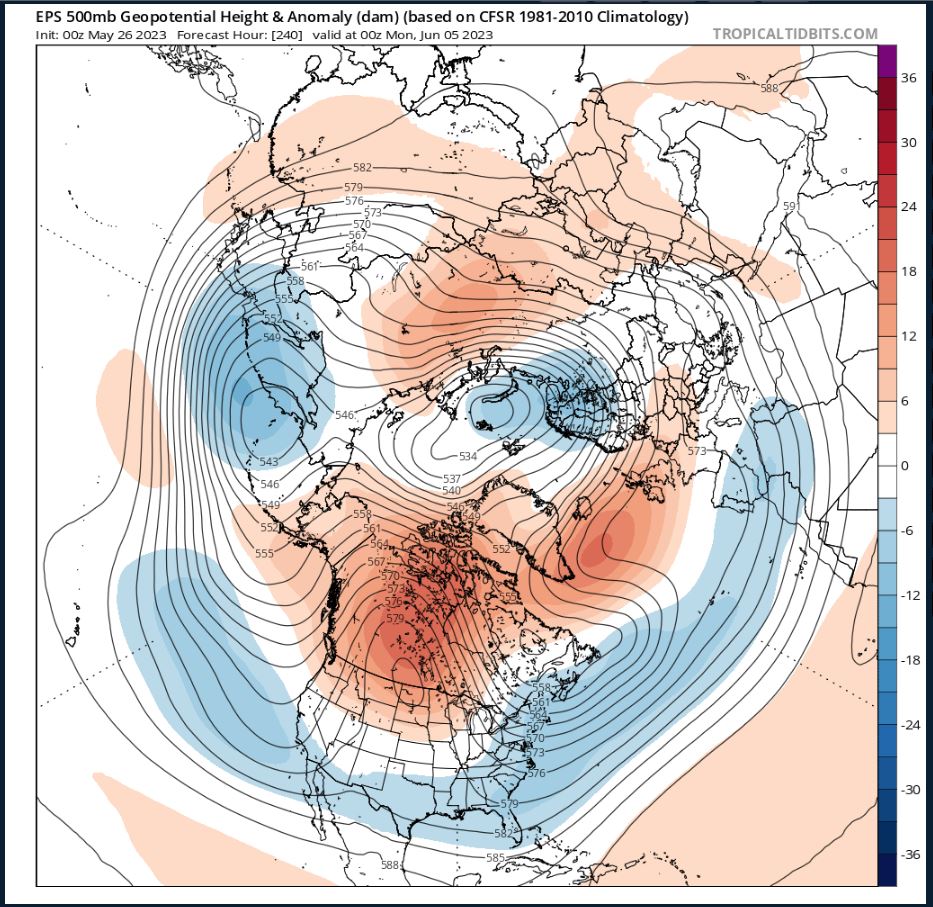
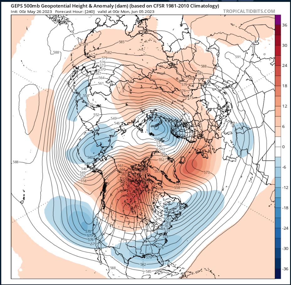
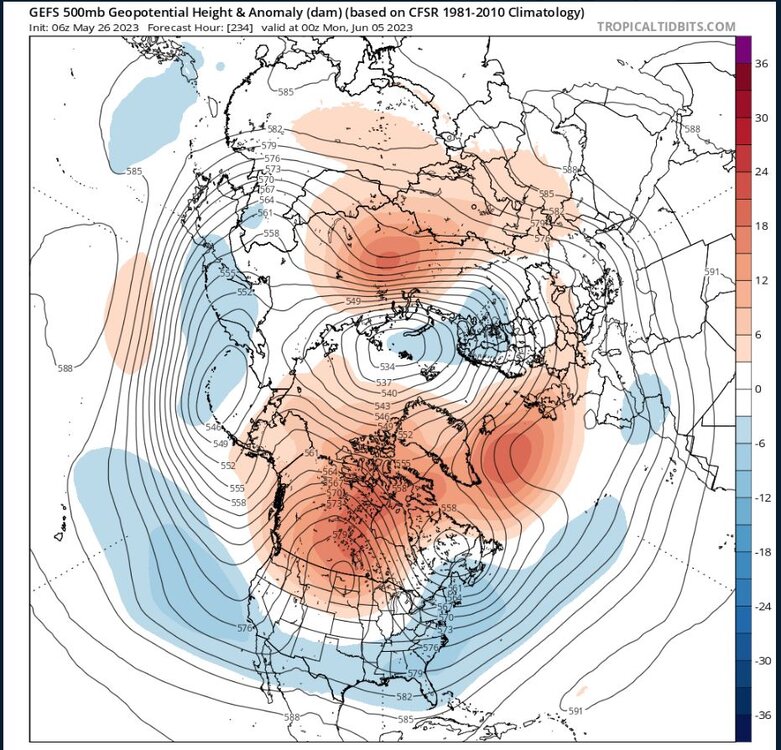
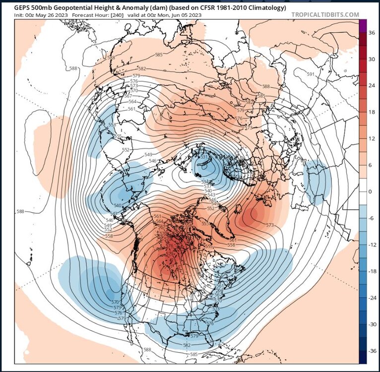
Yes, it's normally quite tough. In this case however, we've got a few "synoptically evident" drivers, two of which are STY Mawar and the location of the Pac jet (STJ). Once that recurves and interacts with the jet and baroclinic zone to the north, it is forecast to induce a large scale wave break via jet enhancement. This is a pretty common occurrence with large/strong recurving typhoons, it's just much earlier in the season than would normally be expected. A strong Bering Sea low and large scale downstream ridging resulting from that RWB is not conducive for the current +AO/annular pattern to maintain its grip. At the very least you would expect some significant disruption for a while.
-
The Canadian province fires experienced so far may just end up being a warm-up if this pattern is to persist as advertised and we may see another smoke-induced aerosol response.
-
Add in CFS weeklies (wk 2-4) and June monthly to that bin -- which have started aligning strongly with the projected pattern of the others.
-
So far, so good and a cursory examination of MODIS reveals most of the ponding is in the CAA so far this year with some small early melt in the Beaufort. An annular upper level pattern (+AO) has been generally protective of the basin proper. However, possible +AD lurking dead ahead with a split stream pattern (enhanced ST jet well separated from a weakened polar jet) and that favors lower heights/cooler temps in the mid-lats/subtropics and enhanced blocking in the upper mid-lats to high latitudes:

-
Yep, read that one! Helluva interesting paper.
-
Yeah, and the strong pos IOD collapsing like that in boreal autumn is a coherent signal for Nina development the following year.
-
There were plenty of reasons to be bearish on a forecasted Nino in '18. No IOD help, lack of recharge time, lack of WWV, etc, etc.
-
The PDO signature erosion is overwhelmingly due to the insane ridging over the NW Conus and far W Canada over the past few weeks. More of that likely on the way, however that may not impact the southern half of the signature much at all. Looks relatively cool in the subtropical belt for a while yet, especially if blocking stays anchored well north (as currently forecast).
-
We'll have to see on that tradewind surge. OP GFS kind of an outlier atm when compared to its own ensembles, EC, EPS, GEM, GEPS.
-
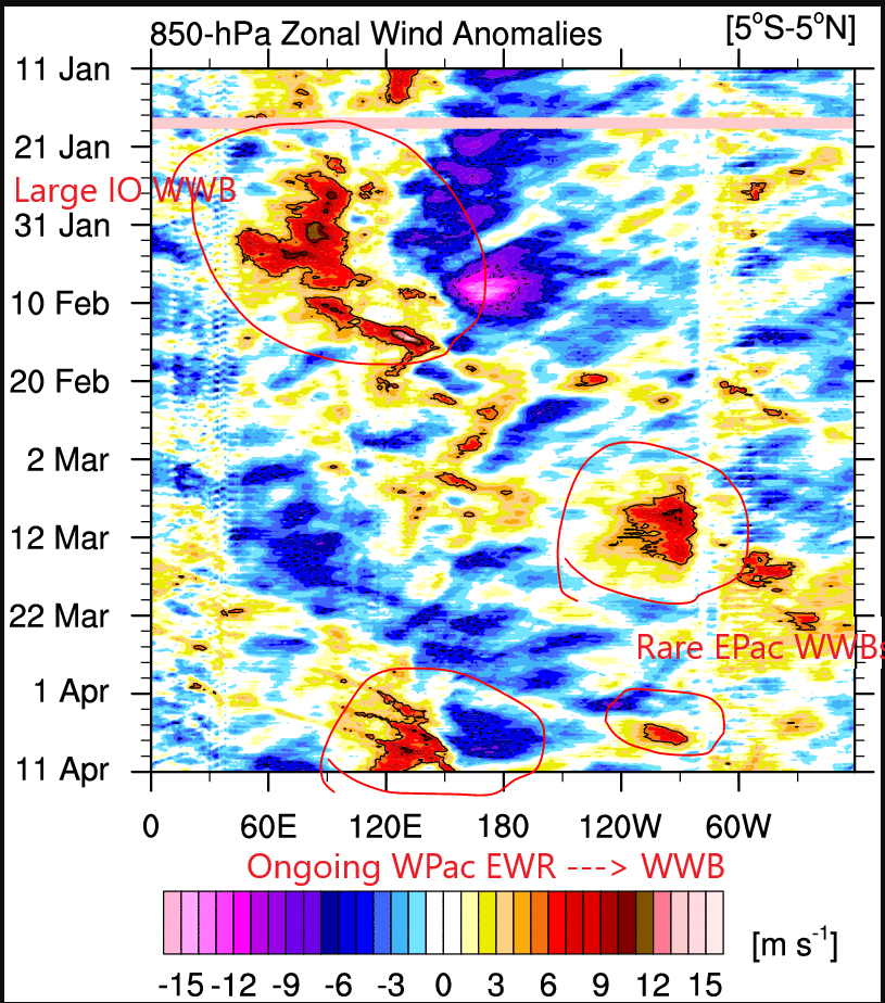
Thanks for the response! That makes better sense. To piggyback on this -- there was a collapse of -IOD conditions starting right around the same time: Peak was in Oct: 2021 0.051 0.243 0.266 0.250 0.009 -0.002 -0.228 -0.099 -0.058 -0.091 0.069 -0.120 2022 -0.056 -0.083 -0.093 -0.068 -0.122 -0.335 -0.195 -0.246 -0.322 -0.691 -0.269 -0.092 2023 0.109 0.157 Final collapse of -IOD in the form of strong IO WWBs took place from Dec to Jan. Most of the mechanisms in this paper we're already familiar with, but it makes the case that a IOD + WWV (warm water volume) has significant predictive value and gives a mechanism of action: https://archimer.ifremer.fr/doc/00002/11304/7831.pdf -- In other words, you can, with actually decent skill scores, pick out the likely emergence of a Nino well before the predictability barrier, in some cases as soon as Sept of the previous year! In this case, it was more like late Oct or November. The lack of any -IOD conditions (much less a sharp peak and cessation) from '17-'21 would've also strongly pointed away from the development of any significant Nino episode. It seems to me we're seeing that mechanism in action and it would go a long way to helping explain some of why we didn't need a classic WPac WWB to kick off the event. Certainly didn't hurt that we had 3 years of Nina conditions in the lead-up.
-
Thanks, didn't notice. Will edit post to reflect that!
-
Perhaps it's poorly worded or perhaps I'm misunderstanding here, but I disagree on one part -- this comes off as classic over-detection of correlation = causation. You set up and fail to show how the causation works as far as a transmission mechanism is concerned from the *subsurface* to the atmosphere (and specifically not SSTs, for some odd reason) which, by default, are not in contact with one another. This literally makes no physical sense. Should have left it at the AAM pattern. Maybe you meant SST trends leading to a +AAM tendency? Struggling with this one.
-
Yeah, seems overly bullish even if the MDR is warmer. Seems like a season where storms would do better in the subtropics or perhaps the Gulf.
-
This paper set to win again: https://www.nature.com/articles/ngeo760
-
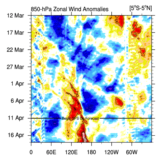
Of course it is -- warm pool is still largely in the WPac whereas the sample you're comparing to it had already migrated. Sample size issues gonna play havoc here. Most important development in the ST will be the consistent (or lack of) WWBs in the WPac and sustaining trade weakness in the EPac. If it wasn't already obvious, the evolution has been different from just about every other ENSO event in the modern era (post-'80), right down to the initiation being an IO WWB (Jan)+EPac WWB (Mar), record strong MJO episode and 3 years of pre-conditioning via a triple-dip Nina.
-
26 inch Fort Lauderdale rainfall
csnavywx replied to bigtenfan's topic in Weather Forecasting and Discussion
Probably coincidence. The amount of heat generated by condensation from ocean fluxes dwarfs anything we can generally produce *directly* (and flights would've been shut down, anyways). Exception is generally from retained solar heat in buildings/concrete, etc -- but wasn't much solar heating going on before that. -
26 inch Fort Lauderdale rainfall
csnavywx replied to bigtenfan's topic in Weather Forecasting and Discussion
Good stats listed here, but I would debate this portion and some of the interpretation. I'll agree it's complex and difficult to tease out. However -- you're generally not going to get environments favorable for supercells in S FL in summer and fall, esp for the kind we saw with long duration. This strikes me as a combination of mid-spring setup overlapping with higher SSTs than should have been available. 1-2C warmer than normal temps/dews temps into a skinny CAPE-high shear profile will absolutely make a difference in both updraft maintenance and precip output, esp if warm cloud layer is deep enough. A few degrees cooler at the surface and in the inflow layer and I'm not even sure you get an event anywhere near this magnitude -- probably several inches less. But in a marginal situation like this? The persistent maintenance of a mesocyclone alone could've contributed up to 50% of the updraft speed. Obvs. it falling over a metro area and the expanding bullseye effect have some blame here too. -
Trades return next week in CP/WPac. Will have to see how big the downwelling EKW was from the recent WWB activity. Meanwhile, in the EPac, EC/EPS have yet another WWB lined up from 110W to the SA coast. Thermocline suppression will remain and with the leading edge of the first downwelling Kelvin wave approaching, we should see some expansion of the warm anomalies to the west. Would like to see the next WWB in the WPac be closer to the Dateline. Will probably have to wait a few weeks for that. In the meantime, full steam ahead.
-
2023 Mid-Atlantic Severe Wx Thread (General Discussion)
csnavywx replied to Kmlwx's topic in Mid Atlantic
Saturday looking halfway decent for southern areas. Tendency towards less AM precip and a bit of clearing ahead of the front. Timing is good. Probably around 500-1000 MLCAPE and great directional shear, DPVA and jet support ahead of a neg. tilt trough. Worth an extension of SLGT northwards.- 2,785 replies
-
- 3
-
-
- severe
- thunderstorms
- (and 3 more)
-
Weak 0.5 Mod 1.0 Strong 1.5 Super 2.0
-
No reason to think we get subsurface cooling over the next 3-4 weeks with a powerful EWR and resultant WPac WWB. Also, atmospheric response lags behind SST changes, so still being in "Nina mode" is expected. This Nino isn't building like recent events and the event so far has started almost entirely from more distant forcing. In fact, the trigger for the end of the Nina can be traced back to a large Indian Ocean WWB in January and the resulting "sloshing" of the warm pool into the WPac. Careful on leaning too hard on analogs. They should only ever form a part of your toolkit. Ma Nature throwing out some strong hints that this evolution will be different from most modern ones.