Kmlwx
-
Posts
13,431 -
Joined
-
Last visited
Content Type
Profiles
Blogs
Forums
American Weather
Media Demo
Store
Gallery
Everything posted by Kmlwx
-

2022 Atlantic Hurricane Season Tracking Thread
Kmlwx replied to WxWatcher007's topic in Mid Atlantic
This is a discussion for banter, though. So I will shut up now. -
2022 Atlantic Hurricane Season Tracking Thread
Kmlwx replied to WxWatcher007's topic in Mid Atlantic
Actually I would 100% be doing this. For two reasons - to be real-time tracking the danger that is about to impact me (I enjoy elements of emergency management as well). I volunteer with MC Park Police here, interned in the past with MoCo Police and considered doing EM as my major at one point. The 2nd reason would be my interest in weather. I'd have Radarscope in my hand while my house was scraped off the face of the Earth. At that point, what can I do to prevent it? Nothing? If I've gotten my family to shelter and have tried my best to protect them - nature is going to be nature. Yes it can be tragic - but without people interested in the science and awe of it - forecasts wouldn't be improving. -
2022 Atlantic Hurricane Season Tracking Thread
Kmlwx replied to WxWatcher007's topic in Mid Atlantic
I think you missed the point of my post entirely. Which is fine - perhaps I was not clear enough. We are (I assume) weather enthusiasts. I know some folks here are here for just snow and that's all. But how interesting is it to track Sunny, 75 degree weather...if I'm being honest that's not being a "weather enthusiast" I personally am fascinated by ALL weather (not just snow). Synoptic wind events, severe storms, snow storms, hurricanes, the works. I know I rarely say this (all in jest @Maestrobjwa) but this is a time when I totally think @Maestrobjwa hit the nail on the head. -
2022 Atlantic Hurricane Season Tracking Thread
Kmlwx replied to WxWatcher007's topic in Mid Atlantic
Another year - and another "ethical" argument. We don't control the weather - but if there must be exciting weather we will track it as any weather enthusiast would. I don't *hope* for a EF-5 tornado to hit my house - but dangit I'm going to track it with awe if it comes my way. -
2022 Atlantic Hurricane Season Tracking Thread
Kmlwx replied to WxWatcher007's topic in Mid Atlantic
Not that it matters this far out - but the wind gust product is pretty garden variety. But again - it's fantasy land lol -
2022 Atlantic Hurricane Season Tracking Thread
Kmlwx replied to WxWatcher007's topic in Mid Atlantic
12z GFS run would likely be a tornado producing track for us . -
2022 Atlantic Hurricane Season Tracking Thread
Kmlwx replied to WxWatcher007's topic in Mid Atlantic
Unacceptable. I want my major hurricane over MBY. -
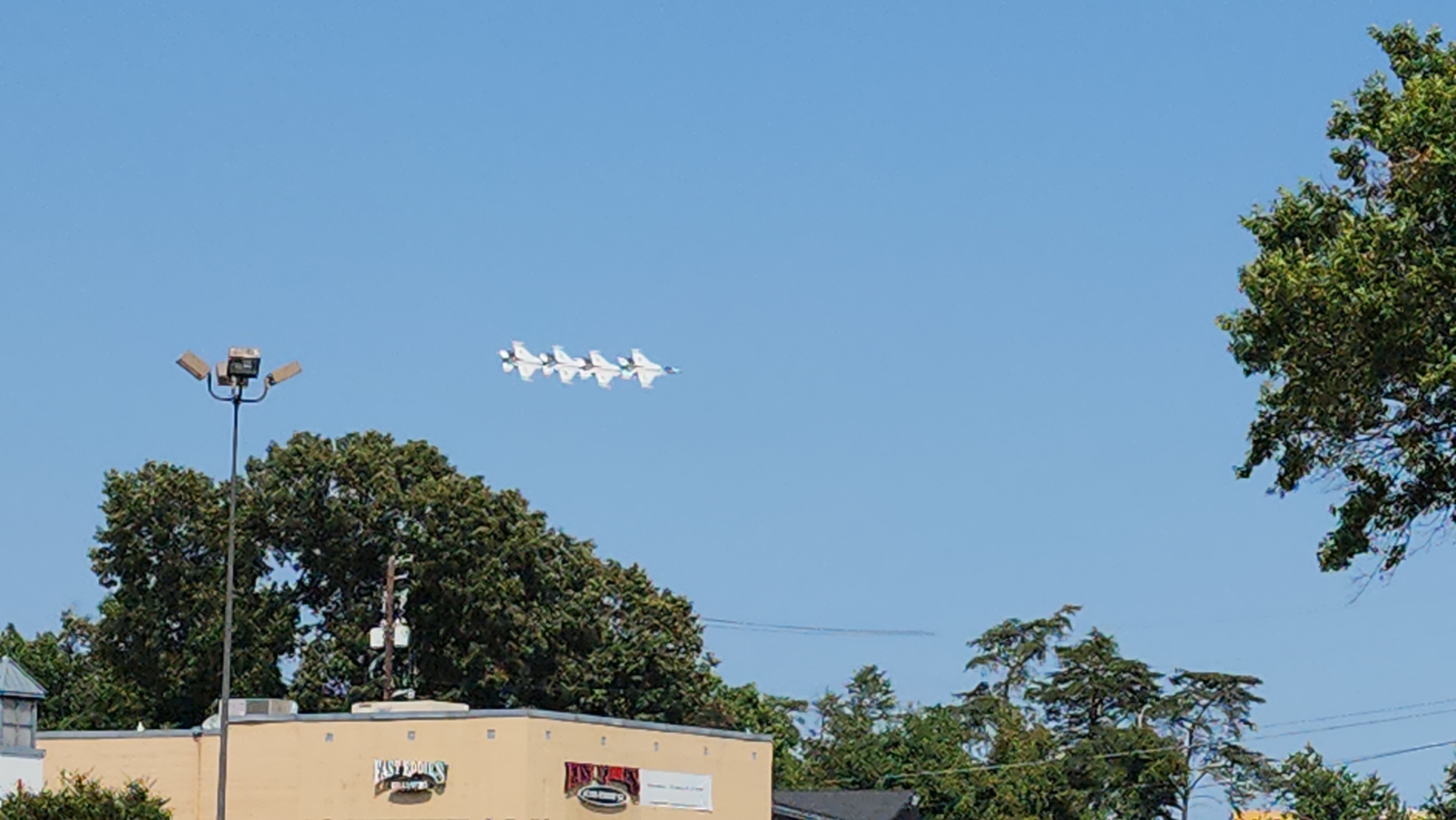
Didn't want to deal with the hassle of the shuttling from FedEx Field to ADW - so was torn on even going to try to see the air show at all. We decided on a whim to head to a strip mall by the base and managed to time our arrival right when some of the jets were starting their maneuvers. Had a blast!

-
2022 Mid-Atlantic Severe Wx Thread (General Discussion Etc)
Kmlwx replied to Kmlwx's topic in Mid Atlantic
It's far away from TBWI, but MoCo activity seems to have some broad spin at higher levels. -
2022 Mid-Atlantic Severe Wx Thread (General Discussion Etc)
Kmlwx replied to Kmlwx's topic in Mid Atlantic
Seeing some shear contours on Radarscope on the MoCo cell. Not sure how accurate those are. -
2022 Mid-Atlantic Severe Wx Thread (General Discussion Etc)
Kmlwx replied to Kmlwx's topic in Mid Atlantic
Yeah some of these cells have the mini supercell look. -
2022 Mid-Atlantic Severe Wx Thread (General Discussion Etc)
Kmlwx replied to Kmlwx's topic in Mid Atlantic
Don't forget November pencil thin gusty shower season. Though with the right negative tilt trough we can perform... There was a day in November 2006 like that I believe. -
2022 Mid-Atlantic Severe Wx Thread (General Discussion Etc)
Kmlwx replied to Kmlwx's topic in Mid Atlantic
Been at a wedding all weekend and haven't been following anything. Was surprised to see the severe thread with posts! -
It blows my mind every time. I just saw your post this morning and I'm scrolling through the map. Thanks for sharing! Amazing that you can see little lumps where houses are and stuff.
-
2022 Mid-Atlantic Severe Wx Thread (General Discussion Etc)
Kmlwx replied to Kmlwx's topic in Mid Atlantic
Good gusts with the outflow in Colesville, MD -
2022 Mid-Atlantic Severe Wx Thread (General Discussion Etc)
Kmlwx replied to Kmlwx's topic in Mid Atlantic
Formidable outflow rushing out ahead of the storms now. -
2022 Mid-Atlantic Severe Wx Thread (General Discussion Etc)
Kmlwx replied to Kmlwx's topic in Mid Atlantic
May have missed a post elsewhere - but is there an ETA on when the TIAD radar will be back up and running? -
2022 Mid-Atlantic Severe Wx Thread (General Discussion Etc)
Kmlwx replied to Kmlwx's topic in Mid Atlantic
Funny that the one to the NE got a 20% and we got a 5% - our radar looks better IMO. -
2022 Mid-Atlantic Severe Wx Thread (General Discussion Etc)
Kmlwx replied to Kmlwx's topic in Mid Atlantic
I'd imagine at some point soon we'll have a meso discussion for our area. -
2022 Mid-Atlantic Severe Wx Thread (General Discussion Etc)
Kmlwx replied to Kmlwx's topic in Mid Atlantic
Radar looks pretty good thus far IMO. -
2022 Mid-Atlantic Severe Wx Thread (General Discussion Etc)
Kmlwx replied to Kmlwx's topic in Mid Atlantic
My dewpoint is holding firm in the low 70s. Better start dropping fast if HRRR is to be correct... -
HRRR mixes out the dewpoints to the low 60s. Not sure I buy it. NAM nest still has a bit of a local minimum through the area - but it's still 66+
-
Wait - what did I do this time?
-
Imagine a "Hall of Fame" style year...would be something else (nobody come at me with the ethical argument of tracking exciting weather/science events). Just think a year with the following all packed into a single 12 month period (or comparable events) 1) All of the winter events of the 09-10 winter. 2) April 28, 2002 severe/tornado event (as the spring event) 3) June 29, 2012 severe/derecho event (as summer time severe event) 4) Random smattering of significant severe days in the peak of summer and into mid-August. 5) Some significant tropical action in the form of an Isabel (but perhaps even more significant...like @Eskimo Joe's left turning tropical cyclone up the west side of the Potomac. 6) September 24, 2001 severe/tornado event as another fall event. 7) Sandy in late October 8) Veterans Day 1987 Snowstorm as an early wintry surprise. 9) A typical December 5th snow event (even if small) to kickoff the next winter 10) More winter storms like 09-10 in December. Also throw in big synoptic wind events in early spring/and later into fall/winter. And just because I'm feeling generous - throw in major heat to make EJ happy.