Kmlwx
-
Posts
13,335 -
Joined
-
Last visited
Content Type
Profiles
Blogs
Forums
American Weather
Media Demo
Store
Gallery
Everything posted by Kmlwx
-
Heck...maybe out seasons are shifting a bit. We all have mentioned that winter seems to start later and later but hang on later as well...fitting that hurricane season would follow that pattern.
-
I wonder if they are going to do rapid center fixes until the Air Force plane gets there.
-
Bearish. Why not just go with Cat 10?
-
The weather just likes making a mockery out of us amateur forecasters and such. If I tell my friends 2-4 inches of snow, it will either be nothing or 6+...if I tell them thunderstorms, they'll all miss. Always the same. We have a pretty toxic hobby
-
Name checks out.
-
Seems a little less dramatic than it looked earlier. But it was still coming down pretty hard on my morning Dunkin run.
-
Hate to say it...but the radar this morning is giving me June 2006 vibes with the linear and training look. It is POURING here right now. If there's not some dissipation or movement of the firehose - there's going to be issues this morning....
-
That first trough doesn't dig like earlier runs on that 12z GFS run - leaves it behind until another trough comes through.
-
I guess it's worth watching the Caribbean in about a week's time then. Though by tonight at 0z runs it's likely to be 1500 miles away from those runs from last night...if it even exists at all. Snoozefest weather lately (locally)
-
Wyze is cheap - some of their cameras can do timelapses too.
-
Pretty meh here so far.
- 1,696 replies
-
- 1
-

-
- severe
- thunderstorms
- (and 5 more)
-
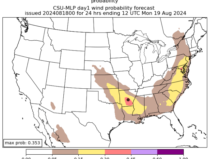
DC jackpot on the CSU MLP for today
- 1,696 replies
-
- 6
-
-
- severe
- thunderstorms
- (and 5 more)
-
About as expected. Long hurricane season remaining, though.
-
I'll be very curious to see the UNL Drought Monitor update next Thursday.
-
Odds seem (as always) low at this point. But if that trough gets cutoff or goes sufficiently negative i don't see why that -couldn't- happen. Seems lots of options are on the table (as always). But that is the big wildcard scenario IMO for east coast impacts.
-
Late reply, sorry! GREarth (requires subscription)
-
Wow this training line looks like it means business. Multiple possible spinny areas embedded in it. Tropical system life!
-
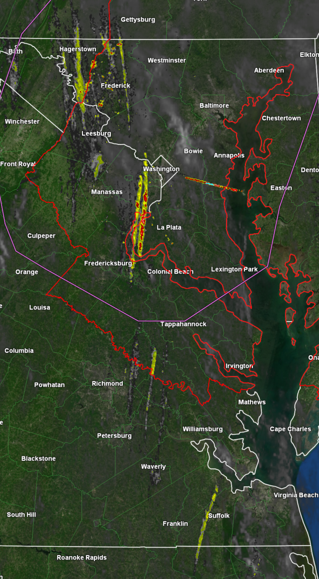
The activity in Charles County, MD has beefed up recently.
-
That stuff east and northeast of Richmond bears watching as it heads up into our area.
-
1hr rotation tracks

-
Just saw they are discontinuing the streamgage near me...seems like a funding issue. Bummed out - https://waterdata.usgs.gov/monitoring-location/01650500/#parameterCode=00065&period=P7D&showMedian=false @Eskimo Joe - Is county funding not something that can help here? Probably a discussion for DM or banter. Seems a few other gauges in the area are "endangered" as well.
-
Decent looking couplet approaching Rockville.
-
Tornado Watch reissued until 2pm.
-
https://caps.ou.edu/reu/reu21/finalpapers/Sloan_FinalPaper.pdf