Kmlwx
-
Posts
13,684 -
Joined
-
Last visited
Content Type
Profiles
Blogs
Forums
American Weather
Media Demo
Store
Gallery
Everything posted by Kmlwx
-
Quite a bit of initiation happening on the higher terrain to the west.
- 2,562 replies
-
- 1
-

-
- severe
- thunderstorms
- (and 7 more)
-
Someone (or a few people) in the next few days - will get microbursted I think. But probably not a region-wide event.
-
HRRR actually has something coming through Central Maryland this afternoon.
- 2,562 replies
-
- 2
-
-
- severe
- thunderstorms
- (and 7 more)
-
-
@Ian was always overrated - meh. All kidding - missed you, dude!
-
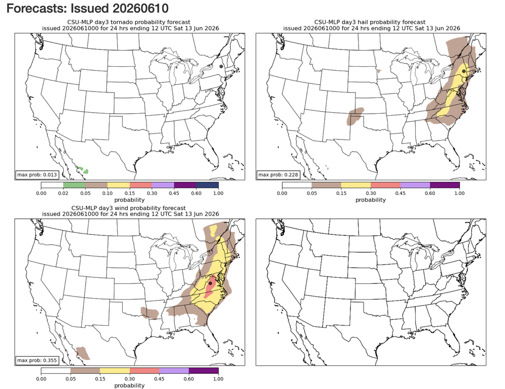
Friday is getting more robust on the CSU MLP page as well - area of 30% showing up.
- 2,562 replies
-
- 1
-
-
- severe
- thunderstorms
- (and 7 more)
-
The one thing that can elevate a normally garden variety threat would be if the outflow from storms can really make a robust cold pool that propagates off the terrain and gusts out. I don't think we'll have a solid handle on how the day(s) will play out until each one is on top of us.
-
Total gut feeling (no science involved) but it feels like the stretch of days where a few people get absolutely smoked by a wind damage core or two and the rest of us maybe hear distant thunder or see mostly sunny skies.
-
Day 2 marginal, Day 3 marginal and day 4 15%
- 2,562 replies
-
- 3
-
-
- severe
- thunderstorms
- (and 7 more)
-
And yeah a deep trough to our west would be a recipe for potential action for sure!
- 2,562 replies
-
- 3
-
-
- severe
- thunderstorms
- (and 7 more)
-
The GFS hinted at some remnant EML advection perhaps on Thursday as well - but we all know that can change with shorter leads.
- 2,562 replies
-
- 1
-
-
- severe
- thunderstorms
- (and 7 more)
-
For now it's a pretty broad brushed area - definitely could (when is it not?) be a scenario of many losers and few winners.
-
CIPS is also fairly supportive of some sort of threat at the end of the week. CIPS extended range remains supportive for severe as well way out into the long range.
- 2,562 replies
-
- 1
-
-
- severe
- thunderstorms
- (and 7 more)
-
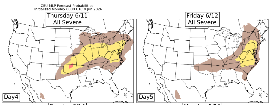
CSU MLP likes both Thursday and Friday
- 2,562 replies
-
- 3
-
-
- severe
- thunderstorms
- (and 7 more)
-
Was only like 10% monitoring today. Impressive to the NW. We'll see if it does anything here. I'm over in Odenton this weekend.
-
Imagine if we flip to a wet pattern and then somehow with a quiet tropical season still get slow moving remnants over us later in the season...
-
Wind signature near The Plains.
-
I always "forget" - but lightning is SUCH a good indicator a lot of times in terms of how a storm is trending. The one well NW of Luray has COPIOUS lightning with it.
-
Watching the stuff to the west of Front Royal/Luray areas for the greater DC area later.
- 2,562 replies
-
- 1
-
-
- severe
- thunderstorms
- (and 7 more)
-
The 6z NAM and NAM nest on the site I'm looking at have storms.
- 2,562 replies
-
- 1
-
-
- severe
- thunderstorms
- (and 7 more)
-
Original spot ended up being closed after I drive out there this morning. Thought I was going to get scraps around the mall area. Got some great shots instead! Glad I didn't rage quit and go home. Toasty out there earlier, though...not looking forward to months of hazy, humid heat...;
-
Central MD special Now if only I trusted the RGEM at this range more.
-
Even the lower CSU is still in the 15% range for wind. Given how boring things have been - I'll take it for some thunderstorm activity!
- 2,562 replies
-
- 2
-
-

-
- severe
- thunderstorms
- (and 7 more)
-
Yeah for sure - I mean am I right in saying that it is mostly attributed to the "doldrums" of summer and just weaker overall systems later in summer? At least spring/very early summer you can still get some dynamic systems with big temperature swings behind fronts and such. I will say - sometimes you will (like you said) get an isolated event that has an absolutely destructive microburst in the area - if that happens in a populated area that can be a "signature event" for some people for a given year.
-
Time is freaking FLYING.
- 2,562 replies
-
- 2
-
-
-
- severe
- thunderstorms
- (and 7 more)