midatlanticweather
-
Posts
4,888 -
Joined
-
Last visited
Content Type
Profiles
Blogs
Forums
American Weather
Media Demo
Store
Gallery
Everything posted by midatlanticweather
-

February 11-12; 12-13: Are they real??
midatlanticweather replied to stormtracker's topic in Mid Atlantic
Wow! And it is a big one to the south! Any more north ticks will be welcome.. but not too soon or big! I like the expanding shield! -
February 11-12; 12-13: Are they real??
midatlanticweather replied to stormtracker's topic in Mid Atlantic
Seems wetter so far further north. Still heavy south -
February 11-12; 12-13: Are they real??
midatlanticweather replied to stormtracker's topic in Mid Atlantic
ALL OF THESE SCENARIOS HAVE HAPPENED AND IT IS PAINFUL TRAUMA. -
This thread should be changes to Sir Mix a little
-
February 11-12; 12-13: Are they real??
midatlanticweather replied to stormtracker's topic in Mid Atlantic
Wow! Richmond and north to Fredericksburg look like the jackpot to me. I think it is a bit south, but not coming north anymore. Just hoping for precipitation expansion now -
February 11-12; 12-13: Are they real??
midatlanticweather replied to stormtracker's topic in Mid Atlantic
Amazing how strong the ensembles were a few days ago. Went from solid to crap. We will see if Euro saves the day., but even it's trends are a cause for concern -
February 11-12; 12-13: Are they real??
midatlanticweather replied to stormtracker's topic in Mid Atlantic
In 24 hours I bet we are worried about mixing again and too far north! LOL! -
February 11-12; 12-13: Are they real??
midatlanticweather replied to stormtracker's topic in Mid Atlantic
Rather have it south than north for bullseye at this point -
February Medium/Long Range Thread
midatlanticweather replied to stormtracker's topic in Mid Atlantic
Too far north -
February Medium/Long Range Thread
midatlanticweather replied to stormtracker's topic in Mid Atlantic
DT had a good update today. He is still good at spotting things in the long range. I think he hits the challenges and why we may speak less snow as we head into next week. Maybe too pessimistic. -
February Medium/Long Range Thread
midatlanticweather replied to stormtracker's topic in Mid Atlantic
Can we will it back south like 2014? A GPT poem The writing is on the wall, a warning clear, a whispered call. Slip, sliding fast to northern skies, we watch it go with knowing eyes. The models now have played their hand, revealing truths we understand. @Ji, the signs are loud and plain— we’re too far south for a big snow again! -
February Medium/Long Range Thread
midatlanticweather replied to stormtracker's topic in Mid Atlantic
-
Location does matter

-
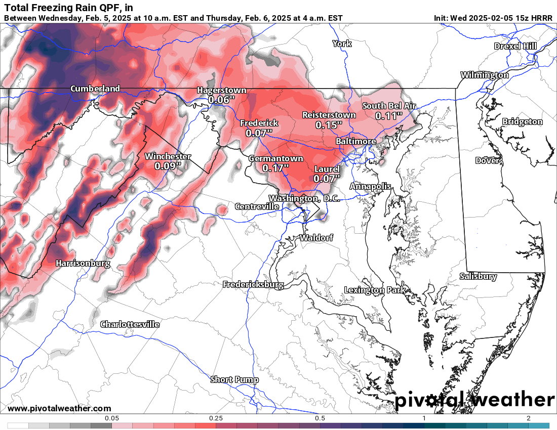
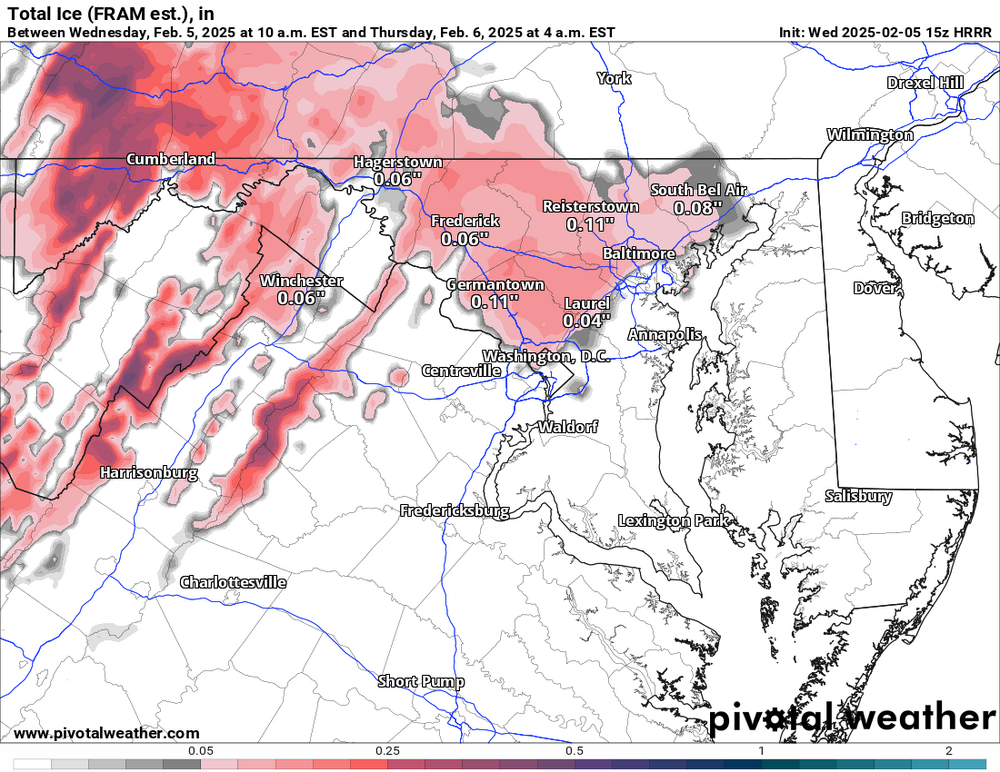
Hrrr says.. Not too many worries.. Not much freezing stuff.. Is it even reliable for this type of event?
-
February Medium/Long Range Thread
midatlanticweather replied to stormtracker's topic in Mid Atlantic
Image does not show for me -
February Medium/Long Range Thread
midatlanticweather replied to stormtracker's topic in Mid Atlantic
While I appreciate the obvious, we all look for trends that increase confidence. The runs are not doing that this morning.. and last evening. Are they real trends, I dunno.. but when we see the erosion of better looks, our past rug pulls, and disappointments, it will bring the bitterness out of a weenie! We should all be cautious, but we all get emotionally attached to the beautiful runs. -
February Medium/Long Range Thread
midatlanticweather replied to stormtracker's topic in Mid Atlantic
Chucking this euro run.. Because it kind of sucked. -
Wow! https://twitter.com/volcaholic1/status/1886740762546581968?s=19
-
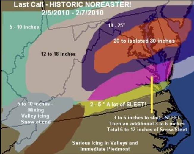
Well, here is a look back to when I made a map for Snowmaggedon! What a storm! Was a bit low in many spots!
-
February Medium/Long Range Thread
midatlanticweather replied to stormtracker's topic in Mid Atlantic
If it supports snow, we believe it.. It is actually good to have unanimous agreement even if we do not trust it. -
February Medium/Long Range Thread
midatlanticweather replied to stormtracker's topic in Mid Atlantic
I am sorry for being lazy.. did the -epo get lost completely on both models? I am curious what the rest of the month past the awesome looking Tuesday holds.. Hard to even think about! -
February Medium/Long Range Thread
midatlanticweather replied to stormtracker's topic in Mid Atlantic
What about this one? -
Agreed. Loudoun, to me, seems they would make the safety call. Some of the roads near the BR can be bad in just rain! That would be why I could see them getting called. Also, I could see watches raised and then lowered to Advisories as needed. But I do realize there is a cost to over concern on tax dollars and plans for many
-
Just enough for winter storm watches western zones. Guessing by 2pm we see what they will post
-
February Medium/Long Range Thread
midatlanticweather replied to stormtracker's topic in Mid Atlantic
I remember the ice not being able to be plowed and breaking equipment. Was definitely glaciers