CheeselandSkies
-
Posts
3,373 -
Joined
-
Last visited
Content Type
Profiles
Blogs
Forums
American Weather
Media Demo
Store
Gallery
Everything posted by CheeselandSkies
-

2024 Short/Medium Range Severe Weather Discussion
CheeselandSkies replied to Chicago Storm's topic in Lakes/Ohio Valley
12Z runs came in a bit hot for Monday-Wednesday after waffling some starting shortly after I made my previous post (go figure). We shall see. -
2024 Atlantic Hurricane Season
CheeselandSkies replied to Stormchaserchuck1's topic in Tropical Headquarters
@ldub23 is a known tropical troll and king weinerhead. He downcasted 2017 hard like three days before Harvey spun back up and did what it did to Texas. -
2024 Short/Medium Range Severe Weather Discussion
CheeselandSkies replied to Chicago Storm's topic in Lakes/Ohio Valley
SPC starting to come on board: Day 4-8 Convective Outlook NWS Storm Prediction Center Norman OK 0346 AM CDT Tue Jul 23 2024 Valid 261200Z - 311200Z ...DISCUSSION... Upper ridging will spread across parts of the Plains and eastern states, while the subtropical high develops westward over the southern tier of the U.S. during the Day 4-8/Fri-Tue period. This will suppress severe thunderstorm potential for much of the CONUS. The exception will be a potentially more active period for parts of the northern Plains into the Upper Midwest due to a series of upper shortwave troughs migrating across the Canadian Prairies and parts of the northern Plains/Upper Midwest through the forecast period. -
2024 Short/Medium Range Severe Weather Discussion
CheeselandSkies replied to Chicago Storm's topic in Lakes/Ohio Valley
GFS has been teasing the next possible uptick in severe potential for the Midwest for the end of the month for a while now. Modest to moderate WNW to NW 500mb flow over 70s dewpoints. Signal is still there as of today's 12Z run, but it's still 7-8 days out so obviously much TBD regarding timing, location, mode and ceiling of threat. -
Currently getting drenched in southwest Madison. Close CGs and loud booms, too.
-
2024 Short/Medium Range Severe Weather Discussion
CheeselandSkies replied to Chicago Storm's topic in Lakes/Ohio Valley
Evansville from 7/15 now confirmed as a 1.23-mile EF0 path. https://www.weather.gov/mkx/wisconsintornadoes We've now edged out 2021 as the busiest year for in Wisconsin out of the last 11. Still behind 2010 with 46, and 2005's record of 62 is probably safe barring a surprise August outbreak (which is also what put that year so far ahead of everything else). Still haven't had one rated EF3+, though and the longest track by far was Evansville-Lake Koshkonong on, go figure, February 8th. -
2024 Short/Medium Range Severe Weather Discussion
CheeselandSkies replied to Chicago Storm's topic in Lakes/Ohio Valley
@Chicago Storm's reply:
-
Yeah, agreed cool drought is the worst, but was stoked for a 1995-esque "hot and active" and we just haven't gotten there.
-
2024 Short/Medium Range Severe Weather Discussion
CheeselandSkies replied to Chicago Storm's topic in Lakes/Ohio Valley
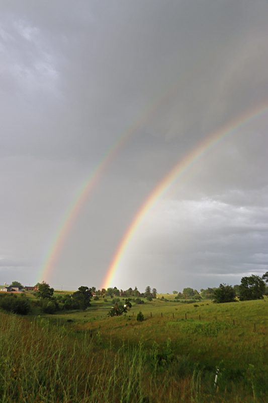
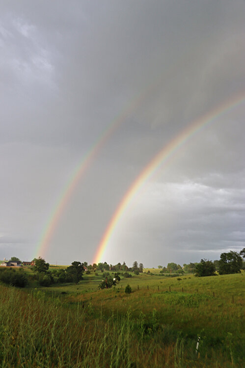
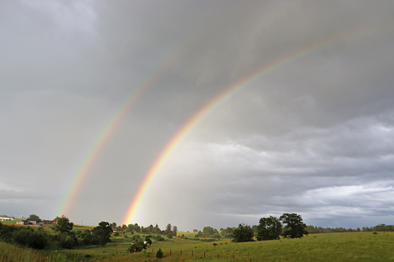
Here in Madison we were on the very northern fringe of Monday's complex; no severe weather (and barely any rain, which is fine given how much we got in the preceding couple of days) but like on June 24th, the setting sun combined with the departing storm clouds illuminated the whole sky pinkish-orange, as intracloud lightning flashed. Some people with a view to the east even caught the lightning with a large, horizon-spanning rainbow. -
2024 Short/Medium Range Severe Weather Discussion
CheeselandSkies replied to Chicago Storm's topic in Lakes/Ohio Valley
Kieler damage was indeed an EF1 that touched down for 1 minute (so not as strong as I thought). Evansville not confirmed despite how low to the ground the funnel looked in the video. -
2024 Short/Medium Range Severe Weather Discussion
CheeselandSkies replied to Chicago Storm's topic in Lakes/Ohio Valley
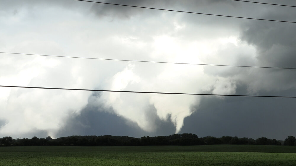
Pretty substantial structural damage at a supper club and a few nearby buildings near Kieler, WI. Wouldn't be surprised if that turns out to have been a brief but strong spin-up. Also at work we have viewer-submitted video of what certainly appears to be a tornado (although it wasn't tagged as "confirmed" at the time) near Evansville (same town that was affected by the record-breaking early February EF2). -
2024 Short/Medium Range Severe Weather Discussion
CheeselandSkies replied to Chicago Storm's topic in Lakes/Ohio Valley
Surprised none of 4/9/15, 6/22/15 and '16, 8/9/21, 3/31/23 or 7/12/23 topped that list. -
2024 Short/Medium Range Severe Weather Discussion
CheeselandSkies replied to Chicago Storm's topic in Lakes/Ohio Valley
Looks like possible tornado just north of Stockton, IL. -
2024 Short/Medium Range Severe Weather Discussion
CheeselandSkies replied to Chicago Storm's topic in Lakes/Ohio Valley
Earlier northward trend to the HRRR runs seems to have been a mirage; will get clipped at most here in Madison, and that only if that northernmost "kink" in the bow over Lafayette/Green Counties can surge northeastward. -
2024 Short/Medium Range Severe Weather Discussion
CheeselandSkies replied to Chicago Storm's topic in Lakes/Ohio Valley
More recent runs of the HRRR ticking north a bit... Sent from my Pixel 8 using Tapatalk -
2024 Short/Medium Range Severe Weather Discussion
CheeselandSkies replied to Chicago Storm's topic in Lakes/Ohio Valley
Majority of CAM solutions are leaning toward a miss south for most of Wisconsin, thus SPC having the Enhanced where it is. -
2024 Short/Medium Range Severe Weather Discussion
CheeselandSkies replied to Chicago Storm's topic in Lakes/Ohio Valley
Furthermore, tomorrow seems like the kind of pattern that has historically supported sneaky S WI/N IL summer sig events...if everything lines up just right. Currently, none of the 33-37 hour CAM solutions really suggest such, but as we know... -
2024 Short/Medium Range Severe Weather Discussion
CheeselandSkies replied to Chicago Storm's topic in Lakes/Ohio Valley
SPC's 13Z outlook is a case study in "the struggle is real." Found my one plant stand blown over again by the round we got this morning; and we got so much rain between the multiple rounds since yesterday evening that any in pots lacking drain holes were being drowned in water. HRRR thinks we should get in on some more boomers this aft/eve. -
2024 Short/Medium Range Severe Weather Discussion
CheeselandSkies replied to Chicago Storm's topic in Lakes/Ohio Valley
Packing a decent punch here despite no longer being warned. Twice blown over one of the plant stands on my balcony. #wewillrebuild -
2024 Short/Medium Range Severe Weather Discussion
CheeselandSkies replied to Chicago Storm's topic in Lakes/Ohio Valley
Pretty sure none of the CAMs I usually check on a regular basis (HRRR, 3K NAM, FV3) accurately resolved the MCS currently passing through southern Wisconsin. -
2024 Short/Medium Range Severe Weather Discussion
CheeselandSkies replied to Chicago Storm's topic in Lakes/Ohio Valley
Well, I hope 12Z 3K NAM is off since it has the next three days being a big fat nothingburger for southern WI. -
-
Catching up on some uploads:
-
One year ago today: Spring/summer 2024 has featured relatively more storms (and associated tornadoes) than 2023, but last year was far kinder to me as far as actually seeing them.
-
Summer 2024 Medium/Long Range Discussion
CheeselandSkies replied to Chicago Storm's topic in Lakes/Ohio Valley
Don't want to jinx it but I'm appreciating the lack of >200 AQI days thus far.