CheeselandSkies
-
Posts
3,360 -
Joined
-
Last visited
Content Type
Profiles
Blogs
Forums
American Weather
Media Demo
Store
Gallery
Everything posted by CheeselandSkies
-

2026 Severe Wx - General Thread
CheeselandSkies replied to largetornado's topic in Lakes/Ohio Valley
Yeah, being the epicenter of a super outbreak will do that. -
Been shut out of even attempting to chase all the recent IL action by the setups occurring when I'm on a family vacation (6/11), on Father's Day (yesterday), or simply too far south for a workday/night chase (the one in between). However, this is what I was doing 10 years ago OTD:
-
Summer 2026 Med/Long Range Discussion
CheeselandSkies replied to Brian D's topic in Lakes/Ohio Valley
...and nearly all of them have been south of I-80/definitely 88. The exception on 4/17 I didn't chase...assumed everything would be HP and it was...except when Harrison-Rockton briefly popped out of the rain and was gorgeous. My only tornado this year is in Minnesota of all places, on April 13. Sandwiched between driving back from my tour which ended in OKC on the evening of 4/12 and nearly wrecking my car chasing 20 miles from home on 4/14. -
All that, and I slept right through the storm.
-
That would be me.
-
Sign of very strong LL shear. I've seen it when arriving to the target area on nearly every chase day I've had when I've either seen tornadoes, or there were tornadoes in the vicinity but I missed them due to being dumb. Shame it will likely go to waste for anyone north of I-72 today.
-
Chase plans cancelled due to clear southward shifts in supercell tornado risk coupled with a brutal week at work. Tornadoes miss southern Wisconsin/IL north of 88 to the north in April and to the south in June? Go figure.
-
I got a DM from someone purporting to be Chris Broyles over on Talkweather; addressing the opinions I've expressed about him in the posts I've made on there (I was a LITTLE more tactful than that!). Not sure if I believe it. That's all I'll say about that.
-
Another potentially epic Midwest outbreak hosed by a morning wind bag. Tale as old as time.
-
Long as we don't repeat the endless smoky skies and hazardous air quality of June, 2023.
-
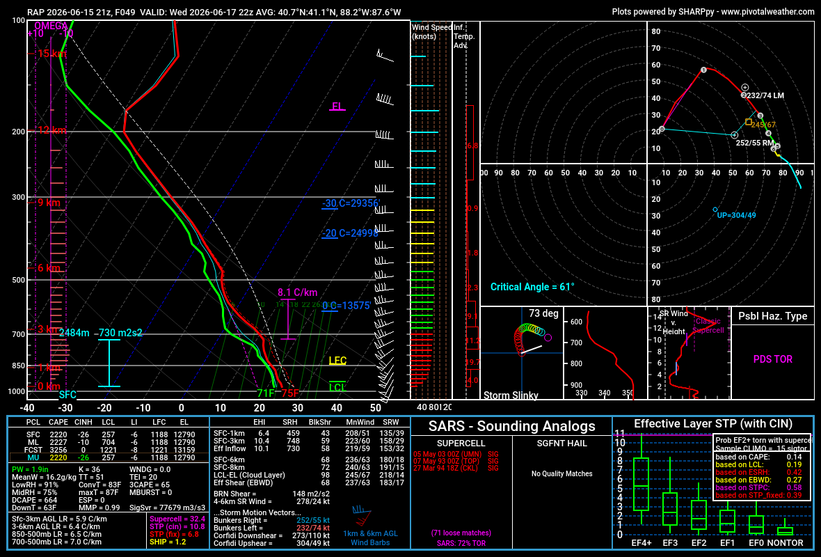
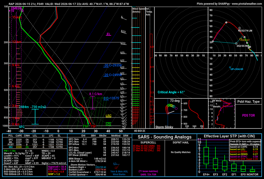
21Z RAP box soundings are nuts. 730 m2/s2 inflow layer SRH.
-
18Z NAM and RRFS-A (I know, I know, but they're the only mesoscale models that go out that far) edged a little bit north with the warm sector for Wednesday evening.
-
I couldn't chase last Thursday due to being in Cleveland on a family trip (probably would have ended up on the still-tornadic relative junk in western IL anyway), but it'd be nice to have the target not be south of I-80 for once since I rarely can take PTO on short notice from my job.
-
Annoyed I will be missing the severe threats in MBY due to a planned trip to Cleveland to visit family tomorrow through Friday.
-
Summer 2026 Med/Long Range Discussion
CheeselandSkies replied to Brian D's topic in Lakes/Ohio Valley
Models give some hope for a return to activity on or about June 14-15, at least for northwestern portions of the sub. Will have been a very long four weeks by that time. -
Spring 2026 Med/Long Range Discussion
CheeselandSkies replied to Brian D's topic in Lakes/Ohio Valley
It really seems like a mixed bag with ENSO. Feels like in my adult life we've had wet Ninos, dry Ninos, wet Ninas, dry Ninas, warm Ninos, cold Ninos, warm Ninas (most dramatically 2012), and cold Ninas. The strength and timing/speed of transition (TNI) makes the biggest difference. -
May 17th-20th severe weather discussion
CheeselandSkies replied to Chinook's topic in Central/Western States
Reupping this thread as several months later I found a frame in my GoPro footage that shows the left edge of the Cullison-Iuka tornado. This is looking north from NW 10th Street northeast of Cullison. It literally was just this one frame, though. Too bad there wasn't more lightning back-lighting under the base. Nearly all of it was at anvil level.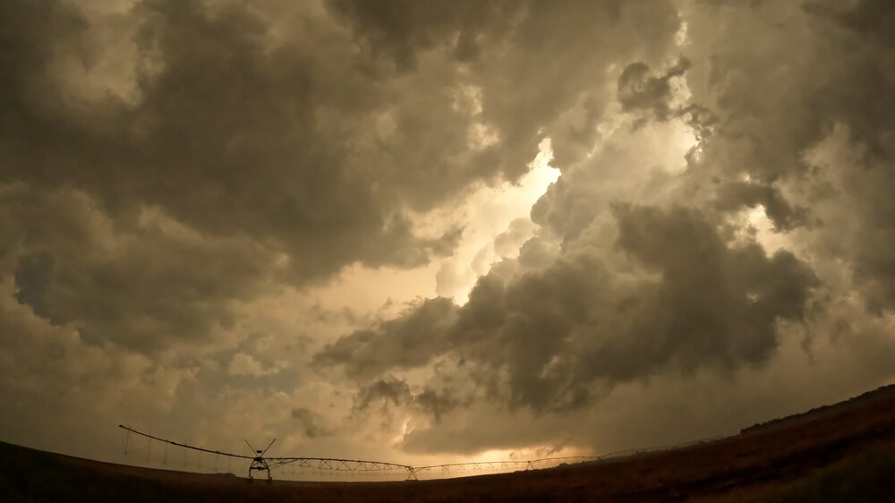
-
Chased this day and intercepted the supercell south of Kalona. Clipped the RFD core heading north and then east to keep up with it, getting numerous subtle but noticeable hail pockmarks on the driver's side and hood of my vehicle. The Riverside tornado was occurring off to our south at about this time, I told my chase partner to keep an eye to his right based on the radar presentation but we couldn't see anything through the rain. Ended up with a distant glimpse of a rope funnel as we approached West Liberty from the south. Chasers who were closer confirmed a ground circulation with this, although the NWS's survey has the only other tornado occurring a few minutes earlier and seemingly a bit further west, southwest of Downey.
-
Southward-moving central WI storms were severe warned into far northwest Dane County, but sputtered into Madison on fumes and have now ceased to exist.
-
Summer 2026 Med/Long Range Discussion
CheeselandSkies replied to Brian D's topic in Lakes/Ohio Valley
God, I hope not. I barely knew what an air quality advisory was until that year. Then we had them in effect for something like 3 weeks straight. -
Gambled on an early to mid-April tour and we lucked out with a couple of decent storms on relatively low-key/conditional days. It was guided by Trey Greenwood and Ethan Moriarty (YouTubers Convective Chronicles and June First, respectively), so it was a lot of fun getting to hang out and talk storms with those guys. However ironically the best was on my way home (I had actually cancelled my flight plans and shortened my time on the tour to drive out to OKC instead, which was the reason I was in my vehicle and able to chase this day, also ironic for someone from Wisconsin I had started the day in Wichita and marathonned 9 hours to see a tornado in Minnesota):
- 306 replies
-
- 10
-

-
Ya. AI ≠ "good."
-
Potential Sever Weather Outbreak 4/27/2026
CheeselandSkies replied to pen_artist's topic in Lakes/Ohio Valley
Does the clearing now pushing from the eastern half of IA/NE MO into NW IL/SW WI mean anything or is it too little, too late? SPC pretty thoroughly chopped away our severe probabilities on the northern end with the 1630 update. -
Potential Sever Weather Outbreak 4/27/2026
CheeselandSkies replied to pen_artist's topic in Lakes/Ohio Valley
00Z HRRR: We're so back? -
Potential Sever Weather Outbreak 4/27/2026
CheeselandSkies replied to pen_artist's topic in Lakes/Ohio Valley
I would agree with you if there was less of a signal for extensive morning convection on the CAMs, however... it's an interesting disagreement between the mesoscale models (NAM, RAP) and the CAMs (3K NAM, HRRR). The former two build a very potent environment into east IA/N IL/even S WI late Monday afternoon/evening, which the latter two fail to do because of the impacts of the aforementioned incessant convection.