CheeselandSkies
-
Posts
3,358 -
Joined
-
Last visited
Content Type
Profiles
Blogs
Forums
American Weather
Media Demo
Store
Gallery
Everything posted by CheeselandSkies
-
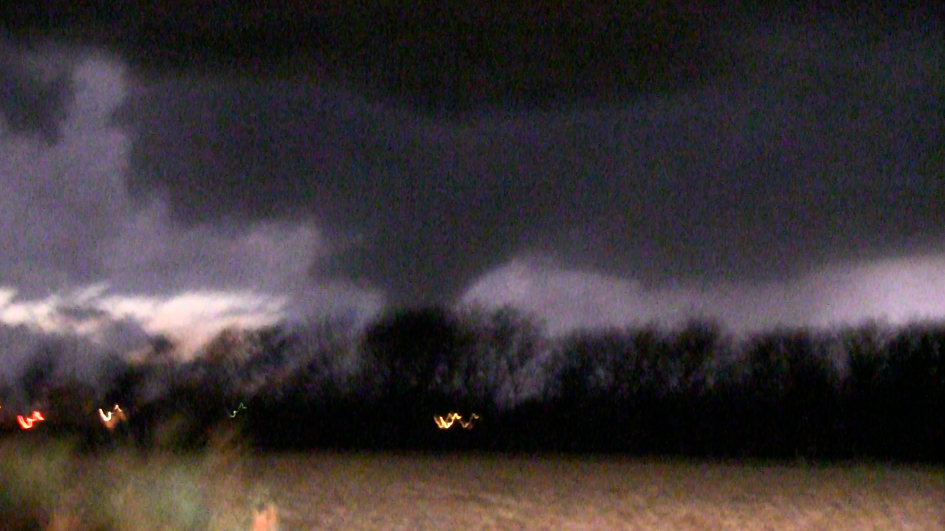
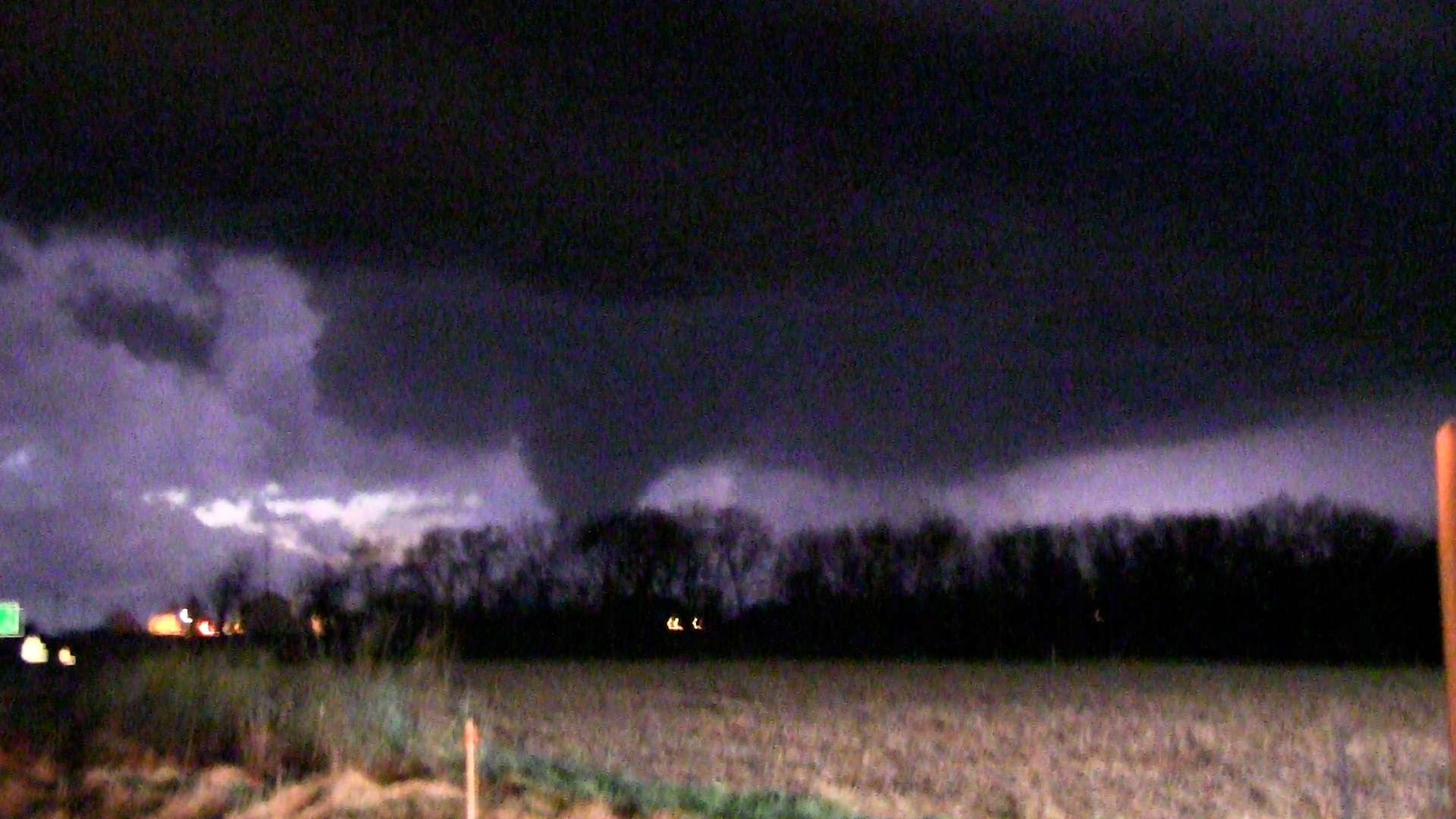
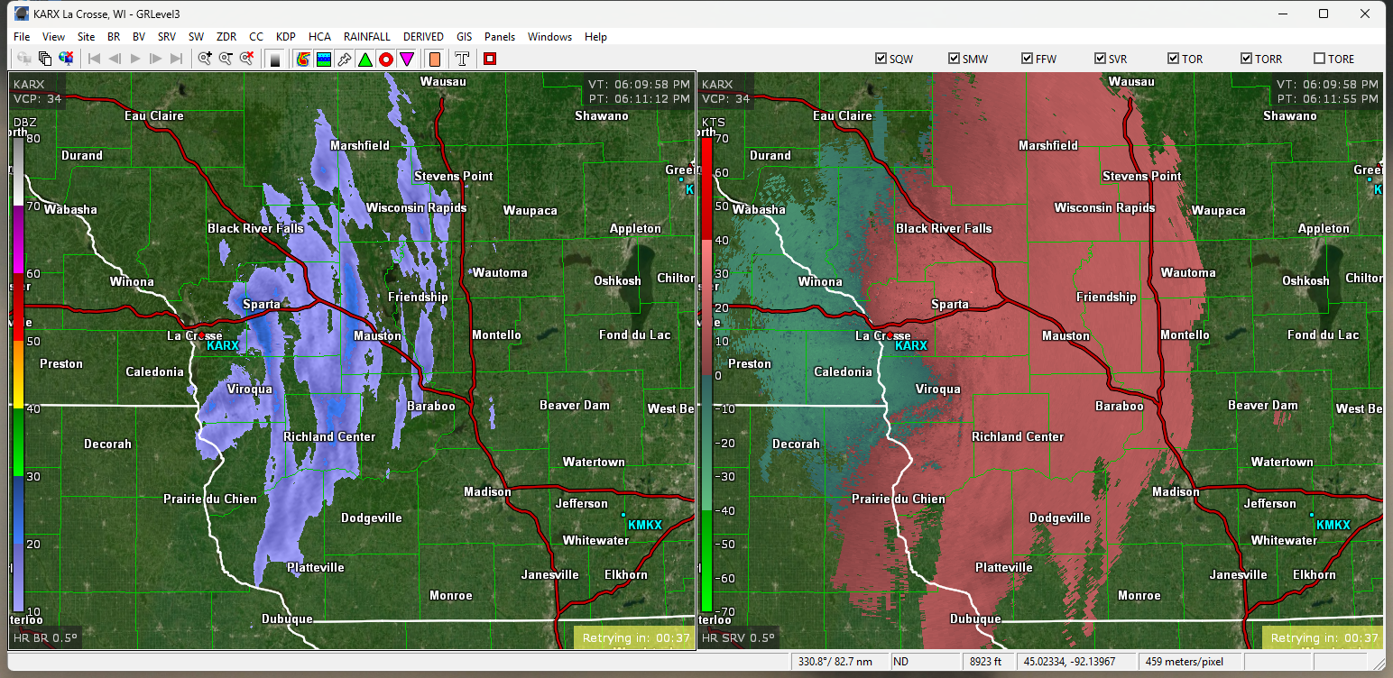
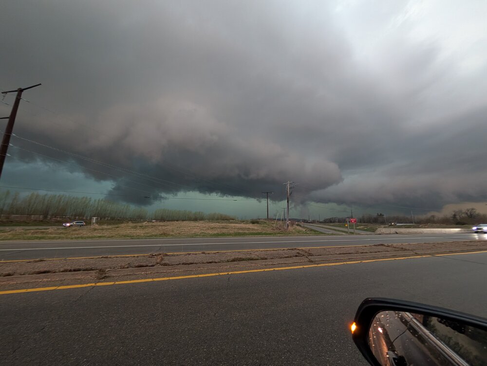
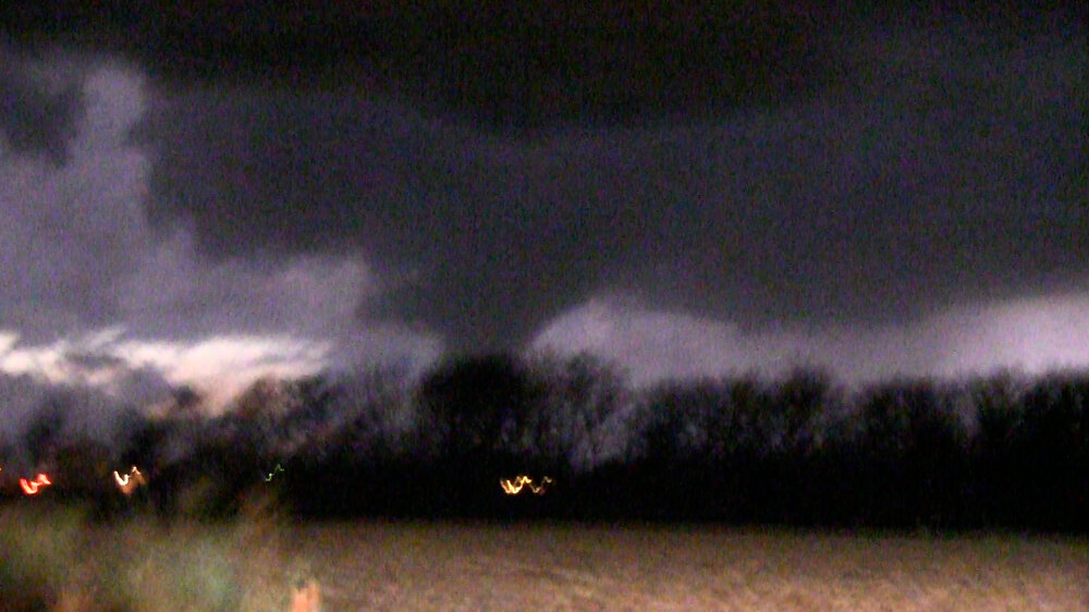
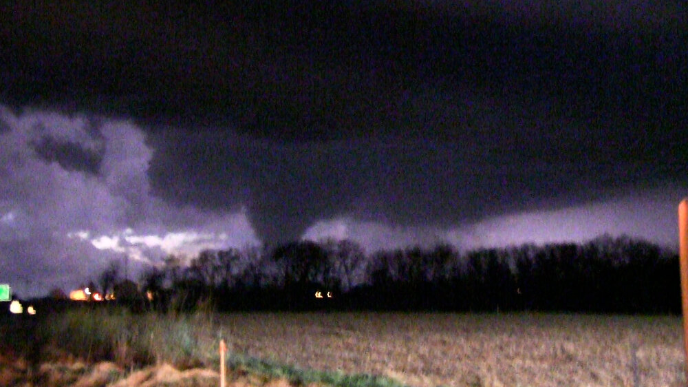
Got this guy on Monday. Was on a tornado-warned nasty green HP near Dodgeville/Barneveld/Mt. Horeb, WI Tuesday evening. Other photos from recent chases in my storm chasing Flickr album: https://flickr.com/photos/andywskies/albums/72157655308092622/
-

2026 Severe Wx - General Thread
CheeselandSkies replied to largetornado's topic in Lakes/Ohio Valley
CAMS (apart from the ever-aggressive RRFS-A) have generally kept southern Wisconsin dry overnight, and the 00Z HRRR continues that trend. Not sure why were still in SPC's slight risk. -
Yeah. I have to resist the temptation to chase based solely on that and the HRRR UH swaths, which are portrayed 50-100 miles north of any surface-based instability except maybe from north-central Indiana eastward.
-
So pumped I get to chase with him starting in a little over a week.
-
Spring 2026 Med/Long Range Discussion
CheeselandSkies replied to Brian D's topic in Lakes/Ohio Valley
Honestly couldn't ask for a better look across all guidance for the start of my chase tour. Now I just have to hope the airports are still semi-functional by the 2nd. Heck, with that look on the models I'll hitchhike to OKC if need be. -
Great shot showing the dramatic carved-out updraft structure. Possibly would have gotten this one except my chase partner couldn't leave work in Madison until 4. We got a brief look at the Trivoli tornado from the west edge of Hanna City, which I believe was produced from the same storm or one that evolved out of it after a merger. We were not really expecting a tornado by that point in the chase as it had gotten dark and the storm had looked like junk on radar just minutes before, so we were rather spooked by the rapid turnaround and hightailed it out of there before we could get a better shot.
-
Spring 2026 Med/Long Range Discussion
CheeselandSkies replied to Brian D's topic in Lakes/Ohio Valley
Chase tour runs April 3-12! -
That's where you tell them "So if you're 'pros,' who's paying you so I can sue them into oblivion for hiring your dumb a**?" Fortunately, while I've seen a few "questionable" driving decisions, nothing egregious like that around storms...so far. Actually had a chase partner for the first time in a while on Tuesday. It was pretty low-key around the Galesburg/Kewanee/Princeton cell, probably because most people were either on the Kankakee storm or frantically trying to get back to it (which no doubt resulted in more bad driving). That sounded like a highly stressful intercept for just about everyone involved, and it seems it was only photogenic for a short time before rain wrapping and/or darkness set in, so I'm not too broken up about missing that.
-
Maybe not. The state girls' basketball tournament is happening at the Resch Center today through Saturday.
-
Absolutely textbook "horseshoe" base and monster RFD cut in that first image. I didn't give the potential for recovery enough credit, I assumed once the lake breeze boundary pushed through that would be sayonara for any supercell in the vicinity. Got on a cell just as it fired north of Galesburg and it looked briefly promising and went tornado-warned for a little while, but a whole bunch of updrafts went up all around and it quickly turned into a mess (potential for that was always there given the boundary-parallel flow, but I had hoped the capping would keep it in check).
-
I think I'm going for an initial target of Galesburg, IL. Multiple models seem to be maximizing the parameters there near 0Z Wednesday, and some initiate discrete convection. In addition, just anecdotally there seems to be something about the west side of the Illinois River valley from Beardstown on up to Peoria; multiple notable tornado events have occurred there in recent years.
-
Three Rivers and Union City, MI would like a word about that. Tuesday looks legit, decent agreement among CAMS on discrete convection initiating within a favorable to highly favorable parameter space. The exception being the NAM 3KM which as has been noted, is likely due to its cool PBL bias. It is a bit of an odd pattern for the location and time of year, bearing more of the hallmarks of a late spring to summer setup for the region (like June 22nd, 2015 and '16) than an early-mid March one (3/12/06 or 3/15/16). However the same was true for last Friday.
-
2026 Severe Wx - General Thread
CheeselandSkies replied to largetornado's topic in Lakes/Ohio Valley
NAM and experimental CAMS have been quite consistent on a high-end parameter space developing over northern Illinois Tuesday afternoon/evening, with a signal for discrete convection able to take advantage of it. At this time I'm planning for it to be my first chase of the year. -
Winter 2025-26 Short Range Discussion
CheeselandSkies replied to SchaumburgStormer's topic in Lakes/Ohio Valley
MKX's forecast for Madison implies MAYBE 2" at most, but multiple models now have us over 5" over the next 36 hours, approaching a foot just to the west. Tonight Snow, possibly mixed with rain, becoming all snow after 5am. Low around 30. Blustery, with a north wind 10 to 20 mph becoming northwest after midnight. Winds could gust as high as 30 mph. Chance of precipitation is 90%. New snow accumulation of around an inch possible. Friday Snow likely, mainly before 9am. Mostly cloudy, with a high near 37. Breezy, with a west wind 15 to 20 mph, with gusts as high as 30 mph. Chance of precipitation is 60%. New snow accumulation of around an inch possible. -
Winter 2025-26 Short Range Discussion
CheeselandSkies replied to SchaumburgStormer's topic in Lakes/Ohio Valley
The 0Z GFS has us getting like 7" of snow over the next 42 hours? That is...not in the forecast, lol.
-
Winter 2025-26 Medium/Long Range Discussion
CheeselandSkies replied to michsnowfreak's topic in Lakes/Ohio Valley
That would be good, because they need it as per @A-L-E-K's post in the banter thread. -
We allegedly won the Cold War but somewhere along the line decided to adopt Soviet architecture.
-
Winter 2025-26 Medium/Long Range Discussion
CheeselandSkies replied to michsnowfreak's topic in Lakes/Ohio Valley
We need to start an American WX winter season thread bingo card. East coast pattern zzzzzzzz (Next month) be rockin' CAD (Beavis rant) ...etc. -
Upcoming pattern shift gives some hope the West will get some snow soon...but yeah that's not good.
-
Winter 2025-26 Medium/Long Range Discussion
CheeselandSkies replied to michsnowfreak's topic in Lakes/Ohio Valley
One thing I've come to learn, after considering it a dirty word following '14 and '18, is that not all SSWEs are created equal (as in, they don't always put the cold into our neck of the woods, which I'd be just fine with given the brutal stretch we're only just finally coming out of). -
It...might snow tonight.

-
Maybe I've missed it, but if not I'm surprised no one has mentioned it's the 15th anniversary of GHD I.
-
Tangentially related: I thought my 3 1/2-year old desktop computer (Bought in summer 2022, previous one lasted nearly 10 years and only died because the power supply burned up because I'd let the fan get completely clogged with dust) was shitting the bed. Starting about two months ago it would randomly freeze, regardless of what I was doing (even just reading a site like this forum, as the only tab in Firefox and no other programs open). It would either reboot without warning, or just abruptly go completely unresponsive to mouse and keyboard inputs and require a hard reboot. Sometimes it would go an hour or two, other times (and this was seemingly becoming more and more frequent) it would do it every five-ten minutes. I opened up the case and vacuumed out the fans (they were somewhat dusty, but far from clogged), ran the hardware diagnostics and everything came back good, installed all the BIOS and driver updates that were available. None of it made any difference and as a last resort before taking it to a repair shop, I went out and bought a $130 UPS/battery backup at Best Buy to plug it (and the monitor, and my external HDDs, etc) into. Lo and behold, we're coming up on 48 hours of up time since I did this after work on Friday, and NO ABRUPT FREEZES/REBOOTS!
-
Couple of weeks ago I was seeing maps that said AA temps for Feb. Shocker.
-
Winter 2025-26 Medium/Long Range Discussion
CheeselandSkies replied to michsnowfreak's topic in Lakes/Ohio Valley
12Z GFS is disgusting. Endless CAD through the end of the run. Although *at least* the last 200 hours of each run of that model are a total crapshoot, I'd really prefer a different look at some point.