CheeselandSkies
-
Posts
3,370 -
Joined
-
Last visited
Content Type
Profiles
Blogs
Forums
American Weather
Media Demo
Store
Gallery
Everything posted by CheeselandSkies
-
Looks like we might be in for another round of hydrologic issues at some point this coming weekend. 0Z 3K NAM is suggesting Saturday night for the most widespread/long duration convection but that is still pretty far out in its range. @madwx
-
5 years ago OTD. Looked a lot like being in a car wash. @hawkeye_wx Probably still a notable lack of trees, right?
-
CAMs (18Z 3K NAM/0Z HRRR) aren't too enthused about much more than garden variety tomorrow. EHI is pretty low. SPC may have been over-optimistic expanding the slight risk into all of S. WI and adding a 2% tornado contour. Edit: 0Z 3K NAM is quite a bit more aggressive than the previous couple of runs. Hard to pin anything down with such lack of agreement/consistency.
-
The jet energy has been there, but it always stays hung up in the Dakotas/MN and never moves east.
-
...annnnnnd it's gone (today's marginal at least, they probably took it away because the HRRR support went away).
-
As hoped, the atmosphere took my post as a challenge. Marginal risk today, slight just northwest of me Saturday. Not looking like anything huge, but better than it was looking just 24 hours ago.
-
What a week ago on the GFS looked like it might finally be a sustained, active severe weather pattern for us this coming weekend into early next week now looks to once again focus well west of the Mississippi River and stay there until it fizzles out.
-

2025-2026 ENSO
CheeselandSkies replied to 40/70 Benchmark's topic in Weather Forecasting and Discussion
Did we not have an extended period of +PDO in the early-mid 2010s? I recall the slower tornado seasons of those years (mainly 2012-2015, notwithstanding events like Rozel, Moore, Pilger, Rochelle) being attributed to that. -
Not this many days with widespread surface air quality impacts. Nothing else comes close to 2023 and 2025 in my memory.
-
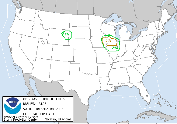
The 18th will be 20 years since Wisconsin's state-record tornado outbreak occurred on a day when the 1630 UTC tornado outlook looked like this: The most notable was the Stoughton F3, to my knowledge still the most recent killer tornado in the MKX CWA and the Madison media market. It missed the house where I was living with my parents at the time by about 1/3 mile to the north (the fatality occurred on the north end of our subdivision). Also still the most recent truly long-track, photogenic, Plains-tier high end tornado in southern Wisconsin.
-
2025 Short Range Severe Weather Discussion
CheeselandSkies replied to Chicago Storm's topic in Lakes/Ohio Valley
Kind of surprised at the 1630Z expansion of the moderate. Recent HRRR runs have trended toward less organized clusters as opposed to the high-end derecho on last night's 0Z. -
2025 Short Range Severe Weather Discussion
CheeselandSkies replied to Chicago Storm's topic in Lakes/Ohio Valley
Models not real keen on the good MCS action from tonight and again tomorrow night making it much east of the Mississippi. Story of the year it seems. -
GFS pretty insistent on patches of 80s dews late this coming weekend/early next week.
-
2025 Short Range Severe Weather Discussion
CheeselandSkies replied to Chicago Storm's topic in Lakes/Ohio Valley
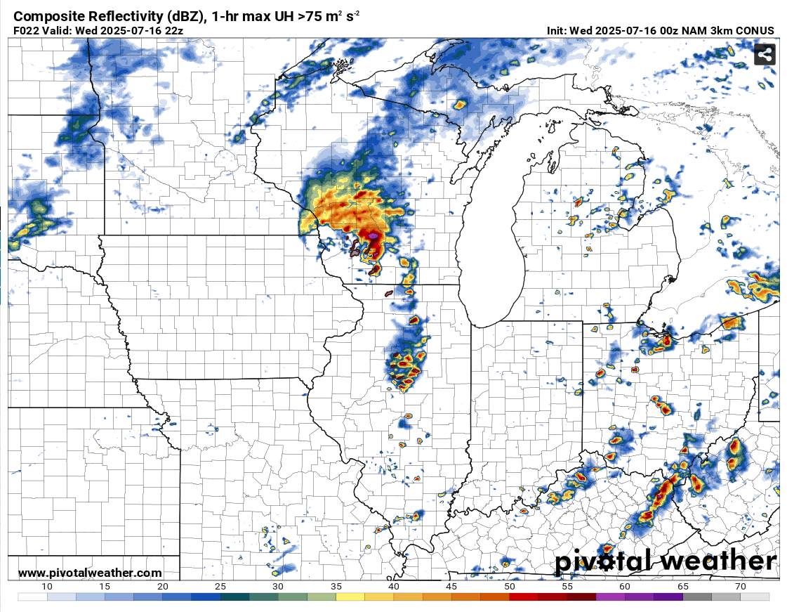
0Z Wednesday (7 PM CDT Tuesday) 3KM NAM valid for 22Z Wednesday (5 PM CDT). Placement of tornadic cells was almost spot-on, but the timing was about 4 hours slower than reality (and much closer to the time of day I would expect tornadic storms).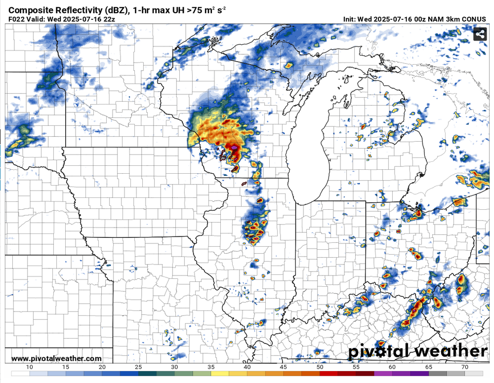
-
2025 Short Range Severe Weather Discussion
CheeselandSkies replied to Chicago Storm's topic in Lakes/Ohio Valley
Timelapse from our former chief engineer's webcam. At 1:31 the inflow band moves overhead and I think a second or two later the tornado spins up toward the right of the frame, he says it didn't form until just out of frame but I think it's just tough to see due to lack of contrast against the rain core from this angle. Then a dramatic RFD clear slot follows as the supercell pushes off to the northeast.- 210 replies
-
- 12
-

-
2025 Short Range Severe Weather Discussion
CheeselandSkies replied to Chicago Storm's topic in Lakes/Ohio Valley
My brief look at the remnants of the previously tornado-warned updraft base near Lake Mills. -
2025 Short Range Severe Weather Discussion
CheeselandSkies replied to Chicago Storm's topic in Lakes/Ohio Valley
All the good stuff happened while I was stuck at work. If this event had waited until around 21Z (like CAMS were suggesting) I would have been right on it. By the time I got off at 18Z, ran home and grabbed my cameras everything was either crapping out or out of reach. Went for the one that had had a nice hook in Green County, it looked like trash when I finally got to it but stuck with it and it eventually went tornado-warned again near Cambridge. Got a brief view of an updraft base with a clear slot near Lake Mills, but that was about it. Tired of always missing everything in my backyard. It's always either too early in the day (you'd think getting off at 1PM you'd have plenty of time to catch a tornado 40 minutes from home), or happens way out of season/doesn't look good enough to go out (2/8/24). -
2025 Short Range Severe Weather Discussion
CheeselandSkies replied to Chicago Storm's topic in Lakes/Ohio Valley
Assuming that complex currently in southeastern South Dakota is the source for our MCV? Looks maybe a tad further north than anticipated based on the placement of today's Enhanced risk. -
2025 Short Range Severe Weather Discussion
CheeselandSkies replied to Chicago Storm's topic in Lakes/Ohio Valley
A miss north for you is a hit for me. -
2025 Short Range Severe Weather Discussion
CheeselandSkies replied to Chicago Storm's topic in Lakes/Ohio Valley
Slight risk out. A state line MCV setup with legs this time? -
2025 Short Range Severe Weather Discussion
CheeselandSkies replied to Chicago Storm's topic in Lakes/Ohio Valley
Wednesday looks potentially interesting, but that could just be me NAM wishcasting again. -
2025 Short Range Severe Weather Discussion
CheeselandSkies replied to Chicago Storm's topic in Lakes/Ohio Valley
SPC vs. 3K NAM...

-
2025 Short Range Severe Weather Discussion
CheeselandSkies replied to Chicago Storm's topic in Lakes/Ohio Valley
GFS has been somewhat interesting for Friday afternoon/evening around northern IL, although it generates so much precip its hard to get a good handle on what the warm sector might actually look like. Near IL/WI stateline, more hodograph curvature, less instability: Further southeast, near SW burbs. Nice fat CAPE and plenty of 0-3KM CAPE: Those hodographs coupled with the high PWATs suggest HP modes to me, however especially on the second one it looks like the SR inflow might be small enough you can get smaller cells that aren't as rainy as you'd otherwise expect. We've pulled that off around here before on days like 8/9/21. -
First *we'd* need to actually have an MCS over here. Although at least we have been doing pretty decent with the popups around Madison.
-
Yet another meteorologically unremarkable tropical system overperforms in the impacts/fatalities department due to freshwater flooding.