CheeselandSkies
-
Posts
3,361 -
Joined
-
Last visited
Content Type
Profiles
Blogs
Forums
American Weather
Media Demo
Store
Gallery
Everything posted by CheeselandSkies
-

4/2-4/3 Potential Major Severe WX Outbreak
CheeselandSkies replied to Geoboy645's topic in Lakes/Ohio Valley
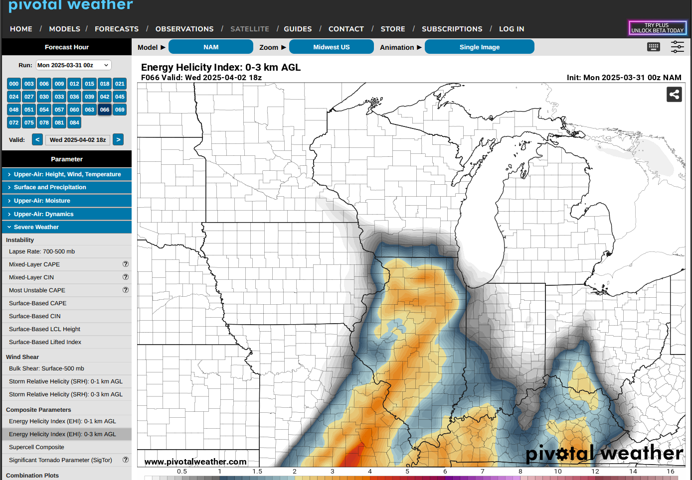
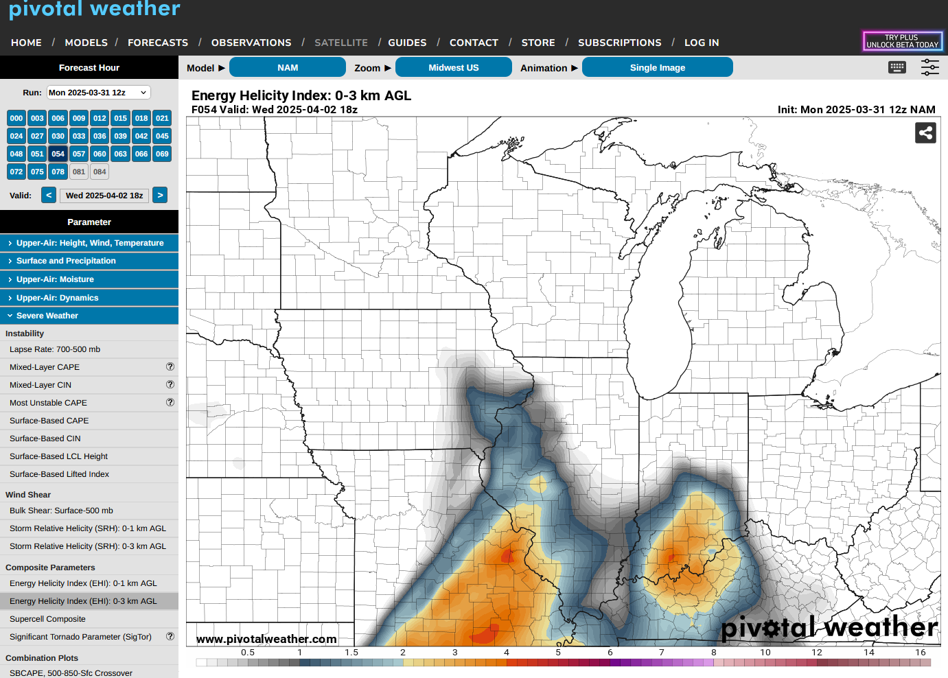
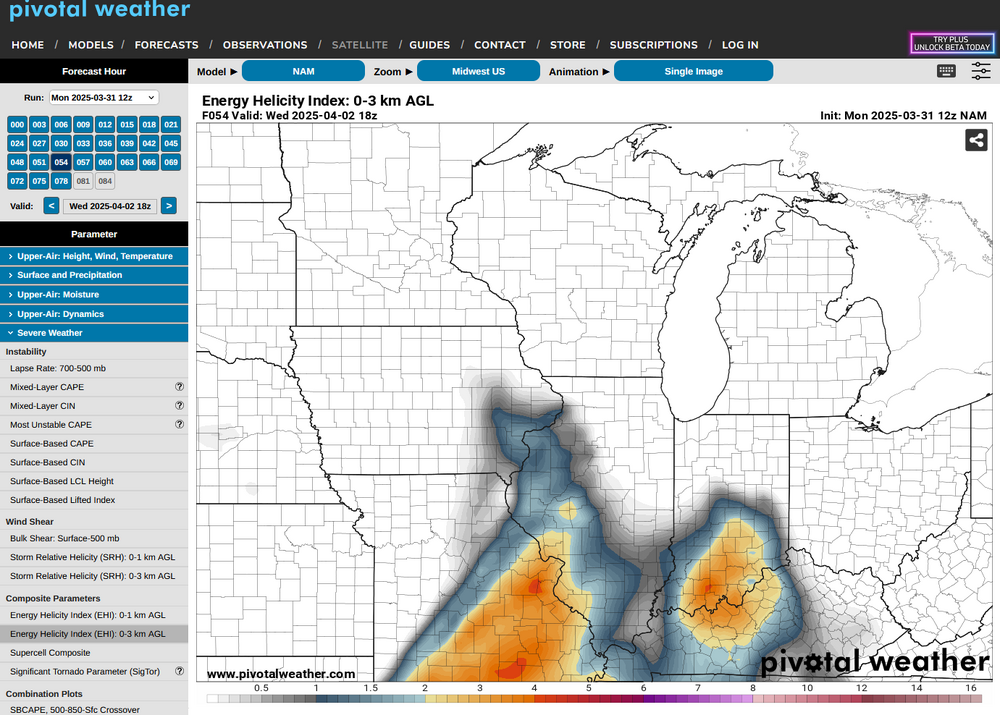
1630Z outlook trimmed all of WI and most of northern IL out of any risk above Marginal. 3K NAM runs were showing high EHI values up to the WI/IL border. -
4/2-4/3 Potential Major Severe WX Outbreak
CheeselandSkies replied to Geoboy645's topic in Lakes/Ohio Valley
Ah yes, the PDS wienerhead outbreak. -
4/2-4/3 Potential Major Severe WX Outbreak
CheeselandSkies replied to Geoboy645's topic in Lakes/Ohio Valley
It's the first run to come in range, but 0Z HRRR washes out the northern IL portion of the setup with a big MCS (left over from what develops tomorrow evening) Wednesday morning. However, it does break out a few dangerous-looking supercells along the Ohio River by 23-00Z. -
4/2-4/3 Potential Major Severe WX Outbreak
CheeselandSkies replied to Geoboy645's topic in Lakes/Ohio Valley
...and with more favorable timing, at that (triple point pushing in at closer to 21Z instead of 18Z). A frustrating amount of flip flopping for inside of 48 hours from the event. -
4/2-4/3 Potential Major Severe WX Outbreak
CheeselandSkies replied to Geoboy645's topic in Lakes/Ohio Valley
As I suspected; latest NAM crashed way down on the forecast EHI/STP values over northern Illinois compared to just 0Z last night.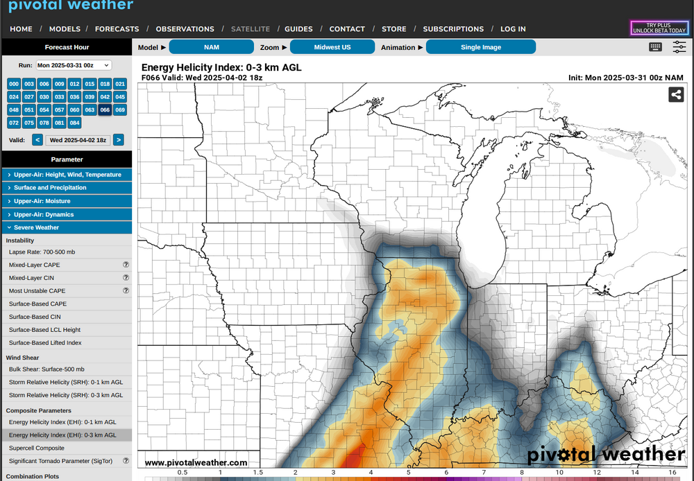
-
4/2-4/3 Potential Major Severe WX Outbreak
CheeselandSkies replied to Geoboy645's topic in Lakes/Ohio Valley
Again, still somewhat skeptical on this as a widespread/significant outbreak which is why I think SPC was wise to hold off on an initial Day-3 Moderate. I could easily see a scenario where the northern part of the risk area (a.k.a. us) gets borked by morning convection and the southern part by veered low-level winds and outflow interactions (like yesterday). -
Well that sure turned around quick. Wasn't I just seeing a bunch of long range outlooks that had positive anomalies in the East/Midwest?
-
Fatality reported at Valparaiso, IN, apparently due to wind rolling a semi truck onto a person.
-
Tornado-warned supercell southwest of Centralia, IL. Low-level rotation doesn't look tremendous, but definitely present.
-
Severe warned cell rolling through the northern Chicago metro.
-
Had a nice couple hours of thunderstorms rolling through early this morning. That followed by this afternoon's 70s and sunshine ought to kickstart the greenup around here. @madwx
-
Eh, to me garbage in early spring is sustained much BA conditions, which I'm not really seeing. Lots of temperature whiplash and chances for precip, which we need. Edit: @Chicago Storm beat me to the punch. Although, conditions can vary quite a bit across the region. I've seen on here how someone from Minneapolis, Chicago, Detroit and Dayton/Cincinnati can have entirely different perceptions of a given season.
-
Spring 2025 Medium/Long Range Discussion
CheeselandSkies replied to Chicago Storm's topic in Lakes/Ohio Valley
With the latest 12Z GFS/NAM outputs, Sunday is getting rather interesting for severe potential especially in the eastern Illinois/western Indiana area. -
NWS forecast for next week Wednesday: Rain likely, possibly mixed with snow. Mostly cloudy, with a high near 54. Chance of precipitation is 70%.
-
0Z GFS wants to give southern Wisconsin a wintry mix with the low on Sunday. Yuck.
-
Spring 2025 Med/Long Range Discussion
CheeselandSkies replied to John1122's topic in Tennessee Valley
Pretty sure the CFS has already backed off considerably on that. Noah Bergren was the guy who was on air with Trent Okerson at WPSD covering the December 2021 tornado outbreak live. Now he's at FOX 35 in Orlando. -
2025 Short Range Severe Weather Discussion
CheeselandSkies replied to Chicago Storm's topic in Lakes/Ohio Valley
Not even within the general thunder contour for today: -
Nice to get some rain that's not imbued with Texas dust.
-
Yeah, liking the drought removal over our area, not a fan of the widespread drought/drought development over the Plains. Maybe it will keep sending more of the our way but will we be able to see them?
-
Spring 2025 Medium/Long Range Discussion
CheeselandSkies replied to Chicago Storm's topic in Lakes/Ohio Valley
Interesting, I keep hearing a lot of talk about how we just had a big SSWE. I used to think those inevitably led to prolonged cold springs in the East/Midwest. -
If they go into the LSRs as tornado reports, they'll appear on the SPC page. However, they won't go into the official count if not confirmed by survey.
-
Again, LCLs weren't looking prohibitive on the CAM (mainly HRRR) forecast soundings even as late as 09-10Z this morning, problem is they didn't verify.
-
Actually a decent patch of clearing (including [lack of] dust) seems to be working its way into WC IL at the moment. Wouldn't be the morning of a chase day without a few headscratchers from the atmosphere, I guess.
-
RAP/HRRR crashed back down to earth hard starting around 11Z this morning. Not sure if the dust had anything to do with it but it's also gonna ruin the photogenic potential of any convection this afternoon.
-
Looks almost pitch black outside with a reddish tint.