

CheeselandSkies
-
Posts
3,361 -
Joined
-
Last visited
Content Type
Profiles
Blogs
Forums
American Weather
Media Demo
Store
Gallery
Everything posted by CheeselandSkies
-
Regardless of whatever else happens, had my first thunder of the year a few minutes ago and it was a doozy. Flash momentarily stung my eyes even though I had my back turned to the windows, followed by a boom that made my apartment building vibrate. Wasn't even really expecting anything more than cold rain at home in the morning with temps in the 30s.
-
Of course, now the HRRR has dramatically backed off its ominous runs from just a few hours ago. Seems the dewpoints will verify on the lower end after all. Still might be a photogenic mini-supercell or two.
-
Yes, however HRRR was bullish off the bat which raised my eyebrows. 3KM NAM and FV3 less so but had the same general idea. Now nearly all CAMs and the RAP have significantly uptrended with moisture.
-
With a 10 hatch in Illinois, I think today is thread worthy.
-

2025 Short Range Severe Weather Discussion
CheeselandSkies replied to Chicago Storm's topic in Lakes/Ohio Valley
Was thinking yesterday Ottawa to Pontiac area looked like a good target. Nice open terrain there, too. -
2025 Short Range Severe Weather Discussion
CheeselandSkies replied to Chicago Storm's topic in Lakes/Ohio Valley
Definitely not "too high to touch the ground." I've been burned multiple times in the recent past by not chasing after underestimating seemingly marginal moisture. -
2025 Short Range Severe Weather Discussion
CheeselandSkies replied to Chicago Storm's topic in Lakes/Ohio Valley
If temps stay in the low 60s (not unreasonable), low 50s dews are plenty for a doable LCL. HRRR is actually suggesting mid or even small pockets of upper 50s are possible. I would have expected it to be mixing to the low 40s. -
2025 Short Range Severe Weather Discussion
CheeselandSkies replied to Chicago Storm's topic in Lakes/Ohio Valley
A bit surprised they are not mentioning a tornado threat whatsoever given the strong shear and the sweet spot of 3CAPE pooling on the HRRR. These seem to be the kind of setups that are conducive for low-topped spinners in this region. -
2025 Short Range Severe Weather Discussion
CheeselandSkies replied to Chicago Storm's topic in Lakes/Ohio Valley
0Z HRRR actually portrays a decent environment over S. WI early-mid afternoon Wednesday, although it doesn't explicitly break out rotating cells.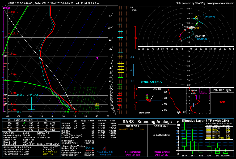
-
2025 Short Range Severe Weather Discussion
CheeselandSkies replied to Chicago Storm's topic in Lakes/Ohio Valley
February 8th 2024 definitely opened my eyes to the range of surface T/Td conditions in which significant are possible, along with Winterset day in 2022. -
2025 Short Range Severe Weather Discussion
CheeselandSkies replied to Chicago Storm's topic in Lakes/Ohio Valley
Looks more interesting than last Friday from a chase standpoint from where I'm coming from. -
March 14-15 Severe Weather Outbreak
CheeselandSkies replied to MazooWeather's topic in Lakes/Ohio Valley
A fair amount of wind reports into southern Wisconsin last night, one pretty close to me although I didn't notice anything too intense, must have been a quite localized gust. Didn't even see/hear any lightning/thunder. I think there was a heavier cell that moved north-northwest through Rock into south-central/southeastern Dane County that was probably responsible for most of those reports. @madwx You see anything? -
March 14-15 Severe Weather Outbreak
CheeselandSkies replied to MazooWeather's topic in Lakes/Ohio Valley
Never fails. Wherever these storms track during outbreaks your 0.5 degree scan is either at 400 or 7,500' AGL. -
...not to mention the severe threat later.
-
Spring 2025 Medium/Long Range Discussion
CheeselandSkies replied to Chicago Storm's topic in Lakes/Ohio Valley
Pending any moisture issues that has the look of another potentially significant threat in the warm sector of that system, and we haven't even begun today/tomorrow's. Verbatim that would be much more favorably placed for a workday chase for me. Today's is just a tad too far to go for storms that will be after dark, after being up since 3:30 this morning. -
March 14-15 Severe Weather Outbreak
CheeselandSkies replied to MazooWeather's topic in Lakes/Ohio Valley
To drive 4+ hours tomorrow afternoon to somewhere in western IL between the Quad Cities and St. Louis for what will likely be after dark, quasi-linear tornadic storms moving at warp speed, or not? That is the question. -
March 14-15 Severe Weather Outbreak
CheeselandSkies replied to MazooWeather's topic in Lakes/Ohio Valley
It's only now at the tail end of its range, but the 12Z NAM at least keeps hope alive for something in possibly western Illinois on Friday. Moisture depth and low-level CAPE improve dramatically from 21-00Z. -
March 14-15 Severe Weather Outbreak
CheeselandSkies replied to MazooWeather's topic in Lakes/Ohio Valley
On the 18Z GFS it appears the moisture surges north a bit by around 03Z Saturday. After dark QLCS threats are always fun... -
March 14-15 Severe Weather Outbreak
CheeselandSkies replied to MazooWeather's topic in Lakes/Ohio Valley
Yeah, was pretty set on a chase Friday until about the 00Z suite last night. Verbatim, LCLs aren't terrible if temps remain in the 60s even with low 50s dews (Winterset day blew my mind that was even possible with those kind of surface thermos), but GFS forecast soundings suggest things might stay capped at those temperatures. -
My wife and I gifted my parents a solar camera-equipped "Bird Buddy" for Christmas. My dad has been texting me some of the clips it captures.
-
Good thing it's early March.
-
Winter 2024-25 Medium/Long Range Discussion
CheeselandSkies replied to michsnowfreak's topic in Lakes/Ohio Valley
Time to move it to this one: -
Quoting myself from the medium/LR thread: Last night's 0Z GFS was a favorable look in that regard, with some moisture being tugged back west beneath quite cold mid/upper levels. Subsequent runs slightly less so, with a narrower wavelength to the trough and consequent more meridional flow in the exit region. Long way to go with this one, but something should happen late next week. The floor is probably something similar to what's occurring yesterday/today.
-
Spring 2025 Medium/Long Range Discussion
CheeselandSkies replied to Chicago Storm's topic in Lakes/Ohio Valley
Hoping the one later next week has less moisture issues and can at least pull off a respectable cold-core potential somewhere in the region. So much funny stuff has happened in that department in this region absurdly early in the season in recent years (from two consecutive years with a March Iowa EF4 to a 26-mile EF2 in Wisconsin on February 8th) it's almost become an expectation. This week's system was a bit of a reality check. -
Last one. Starts with a free car wash courtesy of the Great Midwest Derecho of 8/10/2020.


