CheeselandSkies
-
Posts
3,361 -
Joined
-
Last visited
Content Type
Profiles
Blogs
Forums
American Weather
Media Demo
Store
Gallery
Everything posted by CheeselandSkies
-
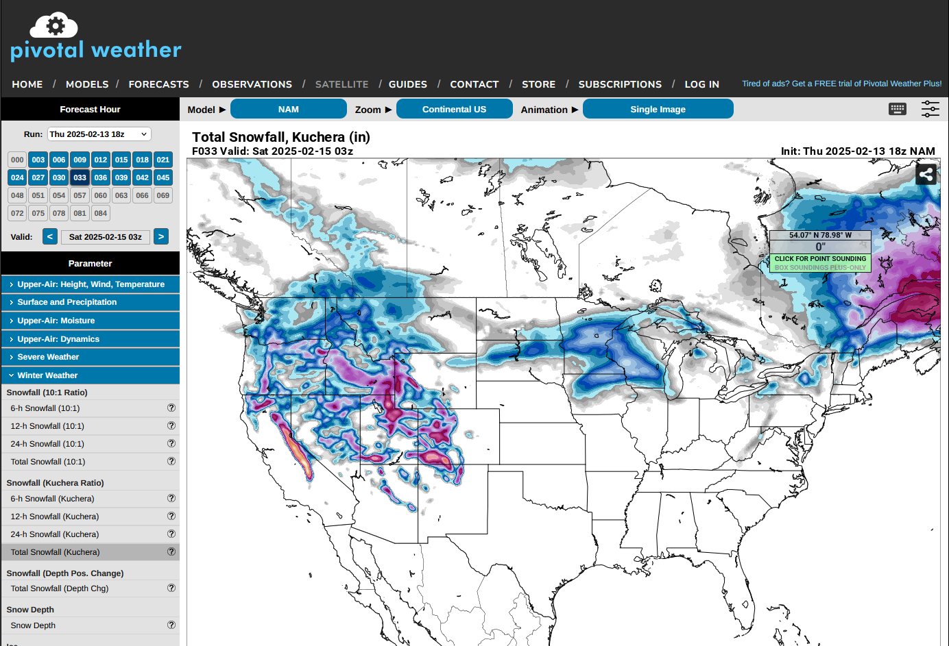
12Z GFS has another system in around 10-11 days that verbatim, despite being another sfc/500mb powerhouse is too moisture-starved for sig (at least in most of this sub). If the timing changes a bit (which it will), it could turn into something, though. Would be a white rain blizzard on the back side on the 13th as depicted. 973MB over Chicago and it's 55 degrees in Milwaukee, ~30 in Madison at 18Z.
-
I certainly hope so.
-
More of my past history of driving around after storms in the region:
-
I like sturms. Sometimes I drive around to look at them. I'm mainly looking for the ones that spin really fast, but even though I usually don't see that I usually see at least a little something cool and/or photogenic.
-
2/28/17 Winterset 2022 2/8/24 There are no rules anymore. That said, the upcoming pattern does not look favorable for an abnormally far north early season severe wx event in the near term.
-
Interesting. A lot of the analogs being pulled by the various TwXers I'm seeing are among the worst springs for chasing in my adult life (2006, 2009 and 2018). However this late winter has not really played out like any of those years locally IMO.
-
Was not expecting that. Almost spun out going from work back to my apartment on my break.
-
I didn't think it was supposed to rain tonight. Have just been hearing about precip chances for Wednesday.

-

Winter 2024-25 Medium/Long Range Discussion
CheeselandSkies replied to michsnowfreak's topic in Lakes/Ohio Valley
There was a similar screw hole depicted on one of these maps a couple winters ago except it was triangular, I called it the "Bermuda Triangle of Snow." -
I'm ambivalent at best about snow (really only here for the big dogs with lots of model hype that verifies; and when has that actually happened? lol), hate driving in it (Go figure, I'm fine with driving a mile from an EF4 tornado, but I don't f*** with winter precip if I can help it) and I intensely dislike the deep cold. However, we desperately needed some sort of snowpack going into spring to avoid a flash drought.
-
2/14-2/15 Potential Major Winter Storm
CheeselandSkies replied to A-L-E-K's topic in Lakes/Ohio Valley
Lobsta. -
2/14-2/15 Potential Major Winter Storm
CheeselandSkies replied to A-L-E-K's topic in Lakes/Ohio Valley
Confusion...what am I missing? 12Z run and 3K output are similar.
-
For the longest time I had no idea this was a real movie...
-
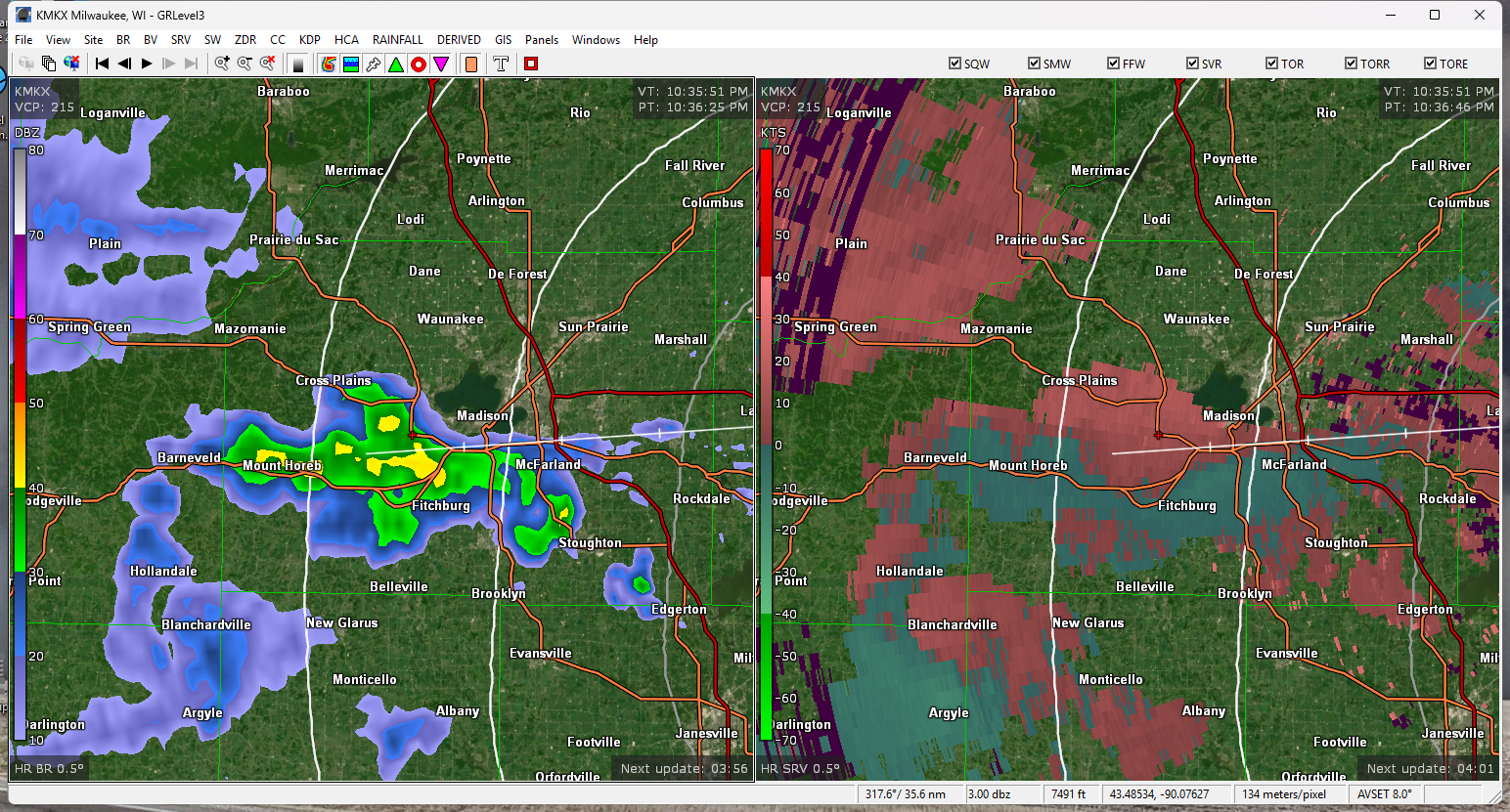
Doesn't look like we've seen a flake at Madison through 1245...
-
Fall/Winter '24 Banter and Complaints Go Here
CheeselandSkies replied to IWXwx's topic in Lakes/Ohio Valley
At least got the sun here today, but not so much the warmth. -
Nothing even really on the KMKX radar and there are numerous crashes on the WI 511 map due to slippery road conditions; and some of the traffic cameras appear to be iced over.
-
Seems like the GFS actually won out with this depiction, then? Most Euro runs were showing a more wound up/impactful system.
-
Winter 2024-25 Medium/Long Range Discussion
CheeselandSkies replied to michsnowfreak's topic in Lakes/Ohio Valley
Certainly hope you're right on the bolded. The absolute worst IMO is a boring D/J, followed by a late winter SSWE which locks in a winterlike pattern for about 8-10 weeks straight starting around Valentine's Day, leading to a chilly, miserable early-mid spring and a stunted/shortened season; yet any would-be significant events are also limited in their impact because they are fighting climo/sun angle. Feels like we have seen several of these in the last decade or so (2018 in particular stands out). -
Winter 2024-25 Medium/Long Range Discussion
CheeselandSkies replied to michsnowfreak's topic in Lakes/Ohio Valley
What is this? An actual signal for a system? This, sir, is the winter of 2024-'25! THIS SHALL NOT STAND! ...in all seriousness, it won't verify but that amount of ice depicted would be catastrophic. The region desperately needs precipitation in any form. -
Remains bone dry here. Sun even came out. Aside from the cold snaps (naturally), this is starting to give me uncomfortable shades of the 2011-'12 winter, which led into a spring/summer when we couldn't buy a raindrop, let alone a .
-
It was all the stations owned by Allen Media Group that were going to do that. Would have been the ABC station here in Madison.
-
Winter 2024-25 Medium/Long Range Discussion
CheeselandSkies replied to michsnowfreak's topic in Lakes/Ohio Valley
Maybe it will bring some early season chances. -
So this is the post-Tuesday "warmup"?
-
Winter 2024-25 Medium/Long Range Discussion
CheeselandSkies replied to michsnowfreak's topic in Lakes/Ohio Valley
24 hours ago, wasn't it "coast to coast zzzzzzzz"? I'd love to see that, but I'd need a few more days of model consistency to even start to hope. -
Fall/Winter '24 Banter and Complaints Go Here
CheeselandSkies replied to IWXwx's topic in Lakes/Ohio Valley
Wagons north, please!...say Jackson, Birmingham, Atlanta.