CheeselandSkies
-
Posts
3,360 -
Joined
-
Last visited
Content Type
Profiles
Blogs
Forums
American Weather
Media Demo
Store
Gallery
Everything posted by CheeselandSkies
-

April 2024 General Discussion
CheeselandSkies replied to PositiveEPOEnjoyer's topic in Lakes/Ohio Valley
Apparently record low (24) set at Dubuque today. Didn't think we were in any kind of noteworthy cold pattern for doing that. -
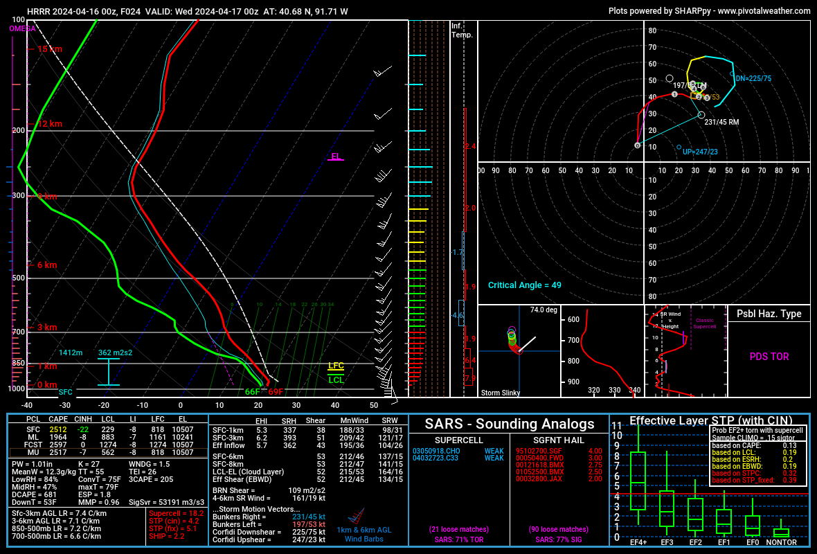
April 16-17 Severe Weather Event
CheeselandSkies replied to nwohweather's topic in Lakes/Ohio Valley
Our @hlcater got some of the better footage I've seen of the tornado of the day (at least duration/impact-wise) which tracked from Houghton-Mediapolis, IA. Me, I was on the storm minutes beforehand but didn't think it looked about to produce and jumped on the southern storm, which was also tornado-warned at the time, and chased it across the river to near Little York, IL but it never did much of interest. Wall cloud looking west on 140th St., south of Houghton or near Mt. Hamill: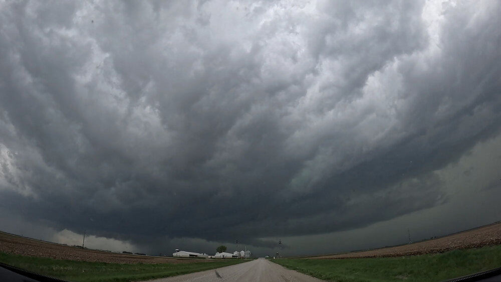
-
2024 Short/Medium Range Severe Weather Discussion
CheeselandSkies replied to Chicago Storm's topic in Lakes/Ohio Valley
Pretty sharp dry slot pushing into SW IA/NW MO. Not a lot of lingering cirrus behind the first round. HRRR back on board with firing a second round after dropping it for a run here or there (notably the 0Z yesterday evening). -
2024 Short/Medium Range Severe Weather Discussion
CheeselandSkies replied to Chicago Storm's topic in Lakes/Ohio Valley
True. -
2024 Short/Medium Range Severe Weather Discussion
CheeselandSkies replied to Chicago Storm's topic in Lakes/Ohio Valley
And of course, 0Z HRRR now cap busts SE IA despite a pretty sexy parameter space. I don't necessarily buy it given how much forcing ought to be present, but not exactly what I was hoping to see.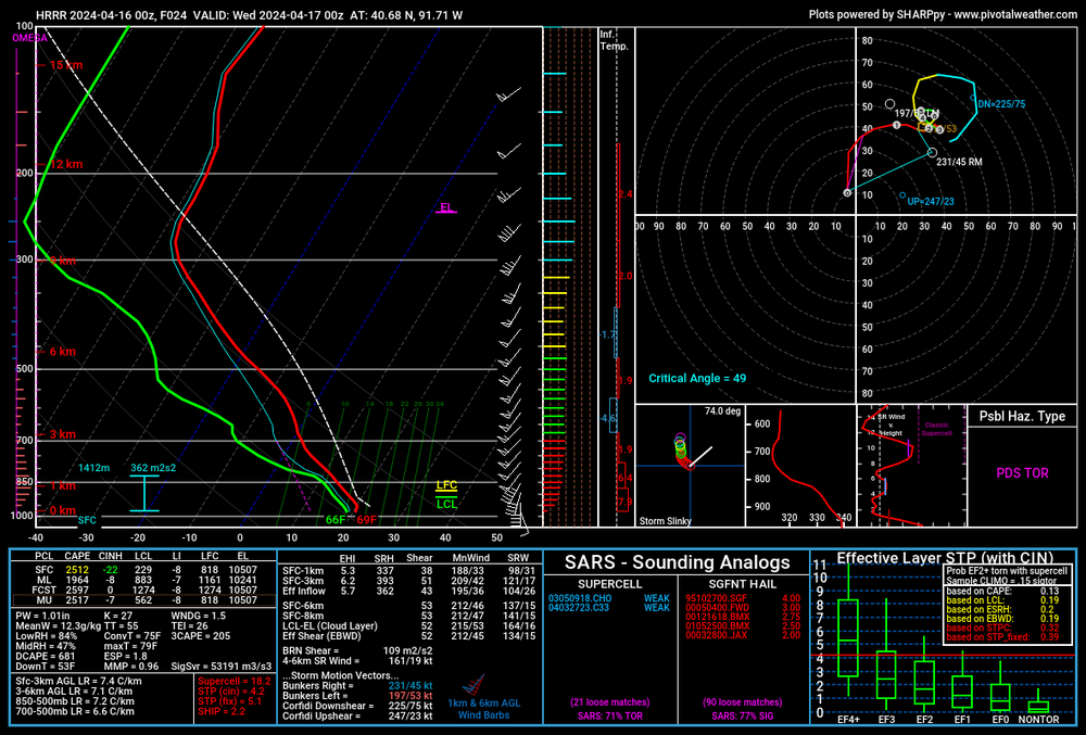
-
2024 Short/Medium Range Severe Weather Discussion
CheeselandSkies replied to Chicago Storm's topic in Lakes/Ohio Valley
Yeah, picture is becoming *a bit* clearer. Pretty much all 18Z CAMs agree on robust supercell development in a solid parameter space, most in the far SE IA vicinity (3KM NAM a little further west). Looks like it's going to be another drive to Mt. Pleasant, IA and evaluate kind of day, need to be more decisive than I was on 4/4/23. Getting my cameras charged... -
2024 Short/Medium Range Severe Weather Discussion
CheeselandSkies replied to Chicago Storm's topic in Lakes/Ohio Valley
Tomorrow certainly going to be very interesting...ought to be at least a couple strongsomewhere near the IA/IL/MO intersection. As to exactly where in that vicinity at this point... Picking a target on 3/31 last year was easy (except the morning of when the HRRR started to make western IL look really good; but fortunately I came to my senses). This is giving me unpleasant vibes of 4/4 when I sat in Mt. Pleasant just long enough to miss both the Pleasantville and Table Grove/Lewistown storms. Ended up going for the latter but was stuck on the wrong side as it coalesced and went tornado-warned, so I just threw in the towel and started driving for home. A chaser I've been acquainted with for a long time and long held in high regard was in a similar situation (probably only about 10-15 minutes ahead of me out of Mt. Pleasant), tried to core-punch to get a view, and ended up having a very bad time of it so I'm glad I didn't do that. -
2024 Short/Medium Range Severe Weather Discussion
CheeselandSkies replied to Chicago Storm's topic in Lakes/Ohio Valley
Hey, I kind of am. I grew up on '90s TWC tornado docs with tons of footage from 4/26/91 since it was THE recent major outbreak of record at the time (as well as one of the first, along with 3/13/90, to take place in the camcorder era with a lot of home tornado video, although still nothing like now when everyone's phone can record 1080p or 4K video). I like to armchair chase a good Plains outbreak if I'm not able to chase it myself. I stay the **** off social media, though. It's long been a wretched hive of scum and villainy and it's only getting worse. 4/26/91 was also considered a major coup for the comparatively primitive NWP of the time; but I now believe it could just as easily have gone the way this one has. It was just "luck" from a forecasting standpoint that a lot of meteorologists called for a major outbreak based on what they saw several days in advance, and it verified. -
2024 Short/Medium Range Severe Weather Discussion
CheeselandSkies replied to Chicago Storm's topic in Lakes/Ohio Valley
The forecast surface pattern for Tuesday afternoon/evening looks pretty darn near ideal for a significant mid-to-upper MS Valley severe weather outbreak (much as it was on 3/31 last year) and I'm seeing many NAM forecast soundings with large 3CAPE values and strong low-level shear; however there are some caveats. - Most of those NAM soundings also have very wonky wind profiles above 700mb, with sharp backing to due southerly at 500mb followed by veering again but weakening at 300mb. - 18Z GFS wipes out instability across IA/IL with a huge amount of ongoing convection throughout the day. This is likely overdone; but still a legitimate potential fly in the ointment. -
2024 Short/Medium Range Severe Weather Discussion
CheeselandSkies replied to Chicago Storm's topic in Lakes/Ohio Valley
IMO, the hype for 4/2 was the stupidest thing I've ever seen in the era of social media weather "forecasting." There was nowhere near the model consistency or agreement on a high-end tornado outbreak; and the trough geometry was totally different than either of the two Super Outbreaks and most of the other known top-tier violent outbreaks. SPC may have inadvertently fueled it by outlining the 15% hatched -driven moderate risk. There are some forecasters there who seem to tailor their outlooks to the "worst-case scenario" rather than the most likely. I disagree with this, but if they feel that's the best way to fulfill their mission to protect lives and property, that's fine. -
2024 Short/Medium Range Severe Weather Discussion
CheeselandSkies replied to Chicago Storm's topic in Lakes/Ohio Valley
From the 13Z outlook. Doesn't sound like the kind of wording that should accompany an Enhanced/10% contour. -
April 2024 General Discussion
CheeselandSkies replied to PositiveEPOEnjoyer's topic in Lakes/Ohio Valley
Decent rain here going to work on those snow piles; should see an explosion of greenery within a few days. -
April 8 Great American Eclipse forecast
CheeselandSkies replied to DLMKA's topic in Lakes/Ohio Valley
Eclipse forecast seems to have improved for my area. Now looking at "mostly sunny" according to MKX. -
I mean, it only goes 24 hours out so you wouldn't have the 10 days of hype. I will say, the simulated reflectivity for the late evening Alabama supercells (that produced Guin, Tanner 1+2, Jasper and Redstone Arsenal) looks somewhat less impressive than I would have expected. Around 02Z-03Z when those storms would have been peaking, it just looks like strung out line segments in the northwest corner of the state, not monster supercells producing some of the most violent tornadoes of what stood as the most prolific tornado outbreak on record for 37 years.
-
Shows how the 500mb setup for this outbreak was completely different than the one for Tuesday of this week and why the Super Outbreak comparisons to that were silly. To really get those high-end outbreaks you need to see those very wide E-W, neutral to moderately negatively tilted troughs with a broad area of SW-WSW (not SSW) 500mb flow in the exit region spreading out into the warm sector.
-
Spring/Summer '24 Banter and Complaint Thread
CheeselandSkies replied to IWXwx's topic in Lakes/Ohio Valley
Was bored so threw this together using my storm footage across the years over the music video to Van Halen's "Humans Being" from the Twister soundtrack. -
4/2-4/3 Significant Late-Season Snowstorm (WI/MI)
CheeselandSkies replied to Geoboy645's topic in Lakes/Ohio Valley
God that April sucked. And coming just 4 years after 2014 which similarly had a much BA pattern locked in for the first 6-8 weeks or so of "spring," I was really afraid that was the new normal. -
Spring/Summer '24 Banter and Complaint Thread
CheeselandSkies replied to IWXwx's topic in Lakes/Ohio Valley
Neither of our major national news partners at work (NBC News, and CNN) have ANY affiliate content available for the 50th anniversary of the Super Outbreak. Zilch. Nada. Another sad reminder that there are severe weather geeks, and then there's everybody else. -
4/2-4/3 Significant Late-Season Snowstorm (WI/MI)
CheeselandSkies replied to Geoboy645's topic in Lakes/Ohio Valley
Happy to do it, just need something to talk about that doesn't mostly go belly-up on the day (fortunately for the OH/IN/KY area, though). In the meantime, feel free to rewatch my Keota video. 3:08 - 3:38 - 30 seconds is what it took to go from a little tendril of condensation curling around the top of the funnel, to that massive collar cloud that would crown the wedge stage. -
4/1-4/2 severe threat (southern portion of subforum)
CheeselandSkies replied to largetornado's topic in Lakes/Ohio Valley
Yeah, some of that hype was just stupid. I'm glad I'm not on Twattle-X or the Reeking Muskverse or whatever it is. To be fair to SPC, they have a pretty unenviable task conveying the type of threat that exists on a day like today. Today certainly could have produced a lot more than it did if a few ingredients had lined up better; but the chances of them lining up were pretty slim, if non-zero. Contrast that to a day like March 31 of last year, which had some of the best model agreement I've ever seen in all the years I've been following weather (I wasn't looking at models much in advance of April 27, 2011, and anyway would have known a lot less about what I was looking at). Globals, mesoscale, CAMs all screamed a significant event, differing only in relatively small details of placement and ceiling. -
4/1-4/2 severe threat (southern portion of subforum)
CheeselandSkies replied to largetornado's topic in Lakes/Ohio Valley

-
4/1-4/2 severe threat (southern portion of subforum)
CheeselandSkies replied to largetornado's topic in Lakes/Ohio Valley
Probably a little of both. The comparisons to 1974 and other ultra high-end outbreaks were ridiculous. This had nothing in common with those other than the general area at risk. Vastly different mid-upper level setup than that which has historically produced the top-tier outbreaks. -
4/1-4/2 severe threat (southern portion of subforum)
CheeselandSkies replied to largetornado's topic in Lakes/Ohio Valley
Yeah, even on another weather forum I suggested that some people throttle back the hype train a couple days ago, mainly due to the consistently progged steep positive tilt of the main trough and had them jump down my throat because "p0siTivELy tilteD TROughS can STIlL pr0duCe MajoR TOrNaDO events." Well, yeah...BUT it is a lot less likely than with neutral to negatively tilted troughs. I can't confidently say that the mitigating factors we saw with today (and yesterday's) events were direct results of the positively tilted trough, but some (such as boundary-parallel flow promoting junk convection, and the best forcing and cold air aloft lagging behind the warm sector), seem to be common to them. -
4/2-4/3 Significant Late-Season Snowstorm (WI/MI)
CheeselandSkies replied to Geoboy645's topic in Lakes/Ohio Valley
At least there should be an explosion of green when the weekend/early next week warmup finally hits. -
4/1-4/2 severe threat (southern portion of subforum)
CheeselandSkies replied to largetornado's topic in Lakes/Ohio Valley
Broyles on today's 4-8: SO WHY DID YOU INTRODUCE AN AREA????!