

Runman292
-
Posts
766 -
Joined
-
Last visited
Content Type
Profiles
Blogs
Forums
American Weather
Media Demo
Store
Gallery
Everything posted by Runman292
-
Perhaps it is just me, but it feels like a lot of severe weather doesn't impact East TN until sunset or later when instability is lower.
-
Looks like a line is forming west of Nashville.
-
Finally got that Tornado watch until 2 am.
-
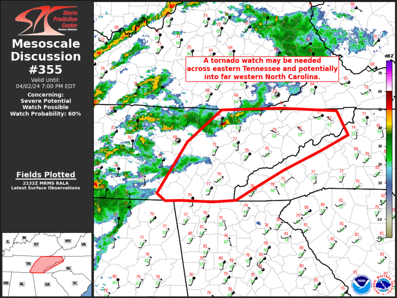
This was posted 25 minutes ago. Probability of Watch Issuance...60 percent SUMMARY...A tornado watch may be needed across eastern Tennessee and potentially into far western North Carolina. DISCUSSION...A supercell has moved east of watch 79 across eastern Tennessee. Additional storm development is questionable as widespread thunderstorms have developed to the west with anvil debris across much of eastern Tennessee. However, at least scattered supercell development remains possible through early evening. The MRX VWP currently shows less than 100 m2/s2 0-1km SRH with the stronger low-level jet to the west. This wind profile is expected to increase after 00Z as this low-level jet slowly moves east. A tornado watch will eventually be needed this evening, as low-level shear and storm coverage increases.
-
Someone reported seeing a tornado touchdown with debris at Pilot Mountain.
-
MRX has released their AFD early: Discussion: The main impact in the forecast period will the the probability for severe thunderstorms later this afternoon through the early overnight hours. Much of the CAM guidance this morning has struggled with ongoing convection with a wide variety of potential outcomes for storm mode and evolution through the overnight hours. However, models have consistently shown 500 to 1500 J/Kg of MLCAPE late this afternoon into the early overnight hours with strong effective bulk shear of 60 to 60 kt with effective low-level shear around 30 kt. Hodographs are showing the potential for some significant length and curvature at times which would create a favorable environment for supercell structures that could coalesce into a QLCS line later this evening with embedded rotation. Current satellite and observations show a wide area of upper divergence across northern Mississippi and West Tennessee that will continue to transition eastward with the upper jet through the evening. Stronger DPVA will result in height falls, moreso after 21z today which will continue to erode the mid-level CAP and increase instability. Current observations show dew points in the low to mid 60s across the Tennessee Valley with a general surge northward through the evening as southwesterly flow increases across the area. All of this points to severe thunderstorms continue to be expected across much of the Tennessee and Ohio Valleys with the potential for damaging winds, hail, and tornadoes.
-
Sun is trying to come out in Oak Ridge.
-
Here's a funny gaffe. 10 news was posting about the Tornado watch that was issued for Southeastern KY, but their graphic says tornado warning.

-
Newest update from MRX: Forecast is on track this morning with severe weather potential expected later this afternoon and evening. Surface obs show a region of low to mid 60s dewpoints stretching from northern AL, through Middle TN, and southeast TN. With additional surface heating through the afternoon, models continue to show MLCAPE around 1000 J/Kg being likely combined with low level shear of 30+kt and bulk shear of around 50 to 60 kt. Model guidance shows fairly large, curved hodographs bringing a potential of mixed mode supercells and QLCS storms through the evening. Many of the CAMs this morning are having a difficult time resolving ongoing convection across the Tennessee and Ohio Valleys. In particular, the HRRR does not seem to be doing a great job with initialization at this time. With the available guidance, you can find a CAM to fit your priors of a very active severe weather event to a more quiet event. The main thing to focus on is that we will have sufficient instability and shear for severe weather - including damaging winds, large hail, and tornadoes - later this afternoon and evening. The severe weather risk remains unchanged with the potential for a fairly widespread severe event across portions of the Tennessee and Ohio Valleys late this afternoon through the early overnight hours.
-
Is it just me, or does it seem like this system is going to arrive in East TN faster than the 6 PM time frame that the local Mets are saying?
-
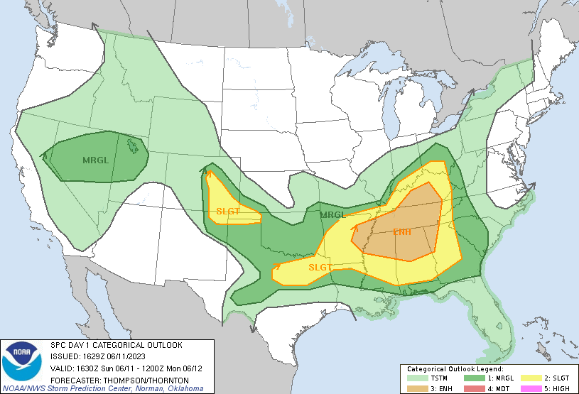
Looks like it's going to be a busy day. ...THERE IS A MODERATE RISK OF SEVERE THUNDERSTORMS ACROSS THE OHIO VALLEY... ...SUMMARY... A potentially substantial severe weather outbreak -- possibly including a few significant/long-track tornadoes -- is anticipated this afternoon and evening, with the highest probability centered over the Ohio Valley. Severe risk exists as far south as the Gulf Coast, and as far east as western portions of Virginia and the Carolinas. ...Discussion... Strong northern-stream upper low, currently located over southern MB, is forecast to drop south across MN into northern IL late in the period. This evolution is driven in part by a 500mb speed max that will translate across the central Plains, increasing to near 100kt over eastern KS/OK by 03/12z. Intense 12hr midlevel height falls are forecast across much of the Great Lakes, OH/TN Valley, and the northern Gulf States, where values in excess of 200m are expected during the latter half of the period. Synoptic front that is currently draped across the OH Valley will be encouraged to gradually advance north due to the digging trough; however, an extensive corridor of convection currently extends across the MS Valley into the OH valley, which is maintaining cool boundary-layer conditions north of I-70. Latest water-vapor imagery suggests a southern-stream short-wave trough is progressing across eastern KS/eastern OK. This feature will progress downstream and likely aid early-day thunderstorm development near the confluence of the MS/OH Rivers. Seasonally high PW airmass currently extends across northern AR/southern MO into southern IL. NAM forecast sounding for JBR at 15z exhibits 60kt surface-6km bulk shear with SBCAPE on the order of 1500 J/kg. Discrete supercells may evolve ahead of this feature then spread/develop northeast across southern IN/KY into OH. Some uncertainty exists across northern OH/IN regarding destabilization. It's not entirely clear if ongoing convection will allow the warm front to lift appreciably north of its current position. However, large-scale pattern is quite dynamic and favors surface low deepening over southern Lake MI during the latter half of the pattern. NAM struggles to reflect this scenario, thus weaker instability is forecast at higher latitudes. Tornadoes, damaging winds, and large hail are expected with supercells that evolve across the warm sector. Some tornadoes may be long-lived and strong. Farther south, a bimodal severe threat may ultimately evolve with a secondary corridor of more concentrated severe across portions of the northern Gulf States. 500mb speed max is forecast to eject across northern Mexico into TX by 03/00z. This feature will intensify as it translates across LA into eastern TN by the end of the period. There is some concern that severe probabilities may need to be increased across this region to account for this low-latitude speed max during the evening/overnight hours. Strong shear will support supercells along with a threat for tornadoes, damaging winds, and hail.
-
Just got a rare Destructive winds tag on the Warned storm in Knox County.
-
Newest AFD from MRX: Cumulus development is ongoing across central Kentucky which is increasing confidence that the ingredients needed to create a severe weather event are actually materializing this morning. Initiating is ongoing near the strengthening LLJ as the aggressive shortwave moves through. Mesoanalysis shows that all the severe parameters are impressive this morning and with clouds clearing out this morning the debris CU doesn`t look like it`s going to get in the way of increasing instability in the low levels of the atmosphere. All weather threats are possible today, including rotating supercells. Based on current radar trends and refreshed CAMs the timing of incoming storms has slowed down just a tad compared to previous forecast with storms looking to move onto the plateau around noon and quickly moving eastward, pushing east of the mountains before sunset. Main weather message for today is to keep an eye radar and the latest warnings, especially for the commute home from school or work as this is the peak time frame for severe storms.
-
Not liking the fact that MRX is highlighting an increased hail threat in their afternoon AFD.
-
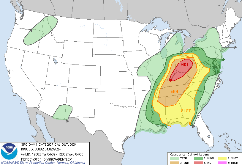
Enhanced risk for most of TN including the western half of East TN this evening. ...Mid-South/TN Valley region through tonight... Around the southern periphery of a closed midlevel low over the upper Great Lakes, embedded shortwave troughs will move eastward over the lower OH and TN Valleys through early tonight. An associated surface cyclone will likewise develop eastward along and just north of the OH River, as a trailing pre-frontal trough and cold front move southeastward across the Mid-South and southern Plains through tonight. Clouds are fairly widespread as of late morning from the southern Appalachians northward into the OH Valley and westward into the mid MS Valley. A little south of the thicker clouds and surface cyclone track, there is a corridor of stronger surface heating from south central KY into the Mid-South, where temperatures will warm into the 80s with mid-upper 60s dewpoints. These surface conditions beneath midlevel lapse rates of 7-7.5 C/km will drive MLCAPE of 1500-2500 J/kg with minimal convective inhibition. Scattered thunderstorm development is expected by early-mid afternoon in the zone of weak low-level confluence/convergence associated with an embedded midlevel speed max, along the edge of the thicker clouds from central KY into western TN and AR. The moderate-strong buoyancy and midlevel flow near 40 kt will support a mix of multicell clusters/line segments capable of producing damaging winds and large hail. There will be somewhat stronger deep-layer flow/shear and a little greater potential for supercells across the Mid-South later this afternoon/evening. The convection will continue to spread eastward and southeastward across the TN Valley early tonight, with some continued damaging-wind threat. Other scattered thunderstorms could form this afternoon/evening to the west of the thicker clouds across the southern Appalachians. The stronger wind profiles/vertical shear will be west and north of this area through the afternoon, so the primary severe threats will be damaging downburst winds and marginally severe hail this afternoon/evening. Uncertainty increases with eastward extent due to the widespread clouds/rain from northeast GA into western NC and vicinity, and the primary increase in flow/shear will tend to occur after the muted diurnal cycle.
-
Scratch my last post. It is a good snow showering in North Knoxville at my church.
-
Flurries in North Knoxville.
-
March 3 High Wind and Severe potential
Runman292 replied to Holston_River_Rambler's topic in Tennessee Valley
97 mph wind gust reported at cove mountain. -
March 3 High Wind and Severe potential
Runman292 replied to Holston_River_Rambler's topic in Tennessee Valley
The sun is out in Farragut and it is very windy. -
March 3 High Wind and Severe potential
Runman292 replied to Holston_River_Rambler's topic in Tennessee Valley
Tornado watch for the rest of Middle TN into the western half of East TN until 5:00 PM EST -
March 2023 Mid-Long Range Discussion thread
Runman292 replied to Holston_River_Rambler's topic in Tennessee Valley
The last time a High Wind Warning was issued for all of East TN was 2006. -
March 3 High Wind and Severe potential
Runman292 replied to Holston_River_Rambler's topic in Tennessee Valley
Something I found interesting in MRX'S AFD and the most recent day 1 outlook from the SPC is the wording "Winds may be strong enough to tear apart storms and keep them from becoming mature." Can anyone explain to me how that works? -
MRX AFD: For Friday, the upper level system and associated strong cyclogenesis will lift northeast toward the Ohio valley. Impressive 850-700mb jet with NAEFS showing anomaly high wind field over the Tennessee valley. The 850mb jet of 75kts+ will move across the region with strong momentum transfer of the low-level jet to the surface. Even though the wind gusts of 50-60 mph in the valley may be below warning criteria, saturated ground will make conditions more susceptible to down trees and power lines. Power outages Friday are likely. Beside the gradient induced high winds, a severe threat also exists. Damaging straight line will be the main concern. Isolated tornadoes are also possible as 0-1km and effective shear are off the charts. Limiting factors are the low-CAPE and possible high LCL heights. Also, the strongest of the synoptic forcing lift north of the area. Will need to monitor the potential of tornadoes closely. Latest HRRR model does show an increasing potential but HREF CAMS showed the best 2-5km updraft helicity tracks over Kentucky.
-
What does this mean?
-
Maybe it is just me, but it does seem like most setups for severe weather in East TN is either High shear/Low CAPE or vice versa. Is the terrain the primary reason why East TN rarely gets both parameters strong at the same time?


