

Runman292
-
Posts
766 -
Joined
-
Last visited
Content Type
Profiles
Blogs
Forums
American Weather
Media Demo
Store
Gallery
Everything posted by Runman292
-
All rain in Oak Ridge with the sun coming out. Wasn't expecting snow, so I can't really say that I'm disappointed.
-
Here's the official storm Survey from Morristown for the severe storms that rolled thru: Damage Survey for 01/12/2023 Tornado Event... A line of strong to severe thunderstorms moved across the area during the late morning and early afternoon hours of January 12, 2023. Several bowing segments within the line products severe thunderstorm wind damage. Three quasi-linear convective system (QLCS) tornadoes were surveyed. ..Decatur 1 SW Tornado... Rating: EF0 Estimated Peak Wind: 75 mph Path Length /statute/: 0.57 miles Path Width /maximum/: 150.0 yards Fatalities: 0 Injuries: 1 Start Date: 01/12/2023 Start Time: 11:50 AM EST Start Location: 2 SSW Decatur / Meigs County / TN Start Lat/Lon: 35.4992 / -84.8043 End Date: 01/12/2023 End Time: 11:51 AM EST End Location: 1 S Decatur / Meigs County / TN End Lat/Lon: 35.5022 / -84.7951 Survey Summary: Straight line winds were observed to have caused several downed trees and minor outbuilding damage near Decatur Creek and Goodfield Road. A tornado developed just southwest of the corner of Sharp Road and Highway 58 as a convergent pattern in the damage path was observed. This tornado tracked northeast across Highway 58 and ended just south of Crestview Lane. ..Dandridge 5 WSW Tornado... Rating: EF0 Estimated Peak Wind: 70 mph Path Length /statute/: 0.42 miles Path Width /maximum/: 30 yards Fatalities: 0 Injuries: 0 Start Date: 01/12/2023 Start Time: 01:14 PM EST Start Location: 3 SSE Piedmont / Jefferson County / TN Start Lat/Lon: 35.975 / -83.5085 End Date: 01/12/2023 End Time: 01:15 PM EST End Location: 3 SSE Piedmont / Jefferson County / TN End Lat/Lon: 35.9773 / -83.5015 Survey Summary: The tornado developed west of Dandridge and crossed Deep Springs Road. It dissipated on the east side of Deep Springs Road near Ranch Road. ..Baneberry 1 SE Tornado... Rating: EF0 Estimated Peak Wind: 80 mph Path Length /statute/: 1.1 miles Path Width /maximum/: 100 yards Fatalities: 0 Injuries: 0 Start Date: 01/12/2023 Start Time: 01:26 PM EST Start Location: 3 SSE White Pine / Jefferson County / TN Start Lat/Lon: 36.0511 / -83.2732 End Date: 01/12/2023 End Time: 01:28 PM EST End Location: 4 SE White Pine / Jefferson County / TN End Lat/Lon: 36.0566 / -83.254 Survey Summary: The tornado touched down near Harrison Ferry Road and moved ENE toward Highway 25E. It crossed the highway with downed trees and power lines before dissipating on the east side of Highway 25E.
-
Basically been rain in Turkey Creek (Farragut).
-
January 2023 Medium/Long Range Pattern Discussion Thread
Runman292 replied to Carvers Gap's topic in Tennessee Valley
Snow hole over Oak Ridge? Sounds accurate, lol.- 923 replies
-
- 1
-

-
- warm start
- cold
- (and 4 more)
-
Historic Christmas Cold & maybe snow?! Dec 23rd-30th
Runman292 replied to Wurbus's topic in Tennessee Valley
I think I might have literally saw 3 flurry flakes and that was it. -
Historic Christmas Cold & maybe snow?! Dec 23rd-30th
Runman292 replied to Wurbus's topic in Tennessee Valley
I wish I would have stayed in Oak Ridge, but I had to go to my family's place to celebrate Christmas and miss out on the snow (I would have thought I would be in a good spot for a clipper in Campbell County, but not the case this time). I'm glad everyone else got to see some snow. -
Historic Christmas Cold & maybe snow?! Dec 23rd-30th
Runman292 replied to Wurbus's topic in Tennessee Valley
Picked the wrong time to visit my family's place in La Follette to see snow, lol. -
December 2022 Medium/Long Range Pattern Discussion Thread
Runman292 replied to Carvers Gap's topic in Tennessee Valley
MRX is now mentioning the clipper, but appears to be brushing it off as a non story. In the upper levels, a potent short wave will move through the region Monday and Monday night. Some snow flurries will be possible mainly in the mountains. The best chance for a light snow shower will be in the northern Cumberland Plateau counties and Lee and Wise counties in Virginia. Little to no accumulation is expected with a dry air mass in place.- 582 replies
-
- 2
-
-
- snow
- freezing rain
- (and 4 more)
-
December 2022 Medium/Long Range Pattern Discussion Thread
Runman292 replied to Carvers Gap's topic in Tennessee Valley
MRX isn't even mentioning the clipper in their latest AFD.- 582 replies
-
- 2
-
-
- snow
- freezing rain
- (and 4 more)
-
Historic Christmas Cold & maybe snow?! Dec 23rd-30th
Runman292 replied to Wurbus's topic in Tennessee Valley
Wow, this is crazy! This is the forecast for Clingman's Dome tomorrow.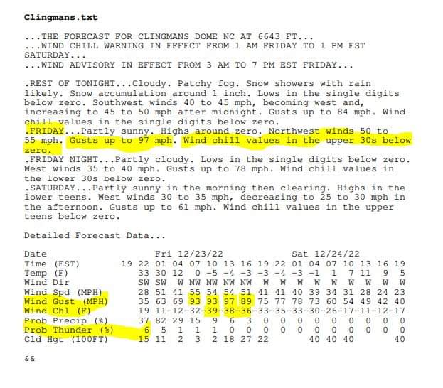
-
Historic Christmas Cold & maybe snow?! Dec 23rd-30th
Runman292 replied to Wurbus's topic in Tennessee Valley
Speaking of historical cold, when was the last time all of TN had a wind chill warning? -
Fall/Winter Banter - Football, Basketball, Snowball?
Runman292 replied to John1122's topic in Tennessee Valley
I am dreading having to work outside on Friday and Saturday from 10 am to 7 pm. I'm probably going to be frozen in place at my work, lol. -
Fall/Winter Banter - Football, Basketball, Snowball?
Runman292 replied to John1122's topic in Tennessee Valley
Good morning, everyone. It's been a while since I've last been on here. I'm sorry that I haven't been posting since last winter, but I've had a pretty rough year. In February, I started getting daily headaches and migraines out of nowhere. I've had a few migraines that have mimicked strokes, which was really scary. On top of that, my wife had a "widow maker" heart attack at the age of 33 in June. I'm hoping that 2023 will be better for me and my wife, and that we get a lot of snow this winter. -
20/12/6
-
MRX AFD for Thursday: Discussion: The main concern of the period is the severe weather potential on Thursday. Agreement on timing looks to be a little better with the NAM now coming in slightly faster, which puts it in better agreement with the other models. If the trends hold, this would put our best chances for seeing strong to severe storms from late Thursday morning through Thursday evening. Due to the mean flow being parallel to the cold front, there will be several clusters of storms move through the area throughout the day. Because of this, it`s hard to narrow down the timing of the severe threat. Setup: A quasi-cutoff upper low will make it`s way out of the Great Plains on Thursday and into Western TN by Thursday evening. A strong upper jet associated with the low and will move into our area through the day. Due to the strong upper jet, combined with high pressure anchored off the coastal Carolinas, a moderate to strongly sheared environment will be in place across our area. Soundings show shear values increasing through the day as the upper jet moves further into the area. The NAM is still the most aggressive with shear values, with 0-1km shear of near 40 kts and 0-1km SRH values around 350 m2/s2 which is concerning. The GFS isn`t as excited however. Looking through the CAMs on SPC`s page, all of the members show a few to several 2-5km helicity tracks across our area. This is further indication of the severe/tornadic potential. Again, the main threats with these storms will be damaging winds and few isolated tornadoes. This will likely be a messy event due to several rounds/clusters of storms moving in through the day. In addition to the wind and tornado threat, isolated flooding will also be of concern due to the moderate to heavy rainfall expected with the stronger storms. The atmosphere will be very moist with PW values averaging 1.6 inches, which is at the 90th percentile for BNA sounding climatology. Also, still anticipating 30 to 40 mph wind gusts across the higher terrain of the east TN mountains through the the day Thursday due to the 40kt 850mb jet in place. The severe threat will wind down Thursday night.
-
It looks like there is a spin on the radar in middle tn. Is that the center of low pressure?
-
Wow, it just went from a thunderstorm moving through to the sun being fully out and clouds disappearing in Oak Ridge.
-
I have a question. Will the storms down in Florida and Georgia have any notable impacts on the storms that form up here?
-
This post is an example of why i love being on this board. I learn more about the weather than i ever would anywhere else.
-
As i just made my post, it looks like the sun is trying to come out in Oak Ridge.
-
I wonder if all of this lingering rain is going to limit the overall severe threat this afternoon. Edit: Dsty beat me to the punch, lol.
-
10 AM update from MRX: An active severe weather day is expected. The main driver of this event will be a negatively-tilted trough with a strong vort max that will be rotating around a closed upper low, and the associated jet streak at the base of that trough. Over the next few hours, we expect that convection will develop along and west of I-75, where the RAP and HRRR show an axis of higher CAPE values. We are already starting to see this development in NE AL at the moment. This instability axis shifts east into the central Valley during the early afternoon, and into NE TN/SW VA in the late afternoon. Aloft, we will have a surge of dry and cooler air aloft that will aid in destabilization by steepening midlevel lapse rates. In the 12Z OHX sounding, we are seeing values of 7.5 C/km, which will be advecting east. Deep shear will be adequate for supercells, and 0-1 km shear values and LCL heights suggest a tornado threat, mainly for areas south of I-40 and east of I-75. However, it is notable that the HREF shows some updraft helicity tracks north of I-40 this afternoon, so a tornado threat can`t be ruled out anywhere. This initial round of storms between 11-4 pm are expected to mainly pose a damaging wind threat with a lower threat of tornadoes, then a second round is expected to develop in the mid to late afternoon near the Plateau, which may be primarily a hail threat as WBZ heights quickly drop as the closed upper low approaches. The HRRR shows this second round crossing our area between 4-8 pm.
-
What are your thoughts on Friday?
-
That was the front, so that's it for the severe weather.
-
Had a good downpour and a few rumbles of thunder in Oak Ridge. Not a lot of wind was at my house.

